METAR & TAF F72
F72 does not publish a METAR.
Showing the nearest reporting station: KSAC (SACRAMENTO EXEC) · 12.9 NM away. Conditions at F72 may differ.
METAR · KSAC
Observed 12:53Z
KSAC 271253Z AUTO 16003KT 10SM CLR 15/12 A2995 RMK AO2 SLP140 T01500117
- Wind
- 160° @ 3 kt
- Visibility
- 10 SM
- Temp / Dew
- 15°C / 12°C
- Altimeter
- 29.95 inHg
- Clouds
- CLR
- Density alt
- -9 ft
- Ceiling
- Unlimited
- Rules
- VFR
Airport info & contacts
Manager on record, flight service, ARTCC, attendance schedule and pattern altitude — published by the FAA and refreshed every 28 days.
Location
- From city
- 4 NM SE
- VFR sectional
- SAN FRANCISCO
- ARTCC
- ZOA · OAKLAND
- NOTAM facility
- RIU (NOTAM-D)
Airport manager
- Name
- RON OGLE
- Phone
- 916-875-6852
- Address
- 5999 FREEPORT BLVD, SACRAMENTO CA 95822-3518
Flight service · Hours
- FSS RIU
- RANCHO MURIETA1-800-WX-BRIEF
- Attendance
- Unattended
Frequencies
Tap any row to copy the frequency to your clipboard.
Runways & pattern
Full pagePattern entry · RWY 18
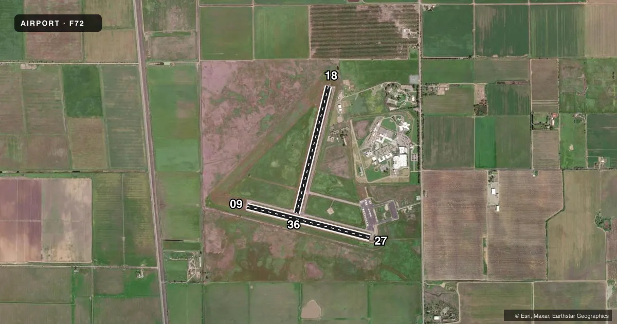
LEFT TRAFFICAirport sketch
Runways drawn to scale from FAA survey coordinates, rendered over satellite imagery. Not for navigation.
Approaches & charts
Services on the field
Fuel grades, oxygen, maintenance, ramp storage and lighting — as declared to the FAA by the airport operator.
Fuel & services
- Fuel
- Not available
- Oxygen (bottled)
- Not available
- Oxygen (bulk)
- Not available
- Airframe repair
- Not available
- Power plant repair
- Not available
Ramp & ground
- Transient storage
- Tie-down
- Landing fee
- No fee published
- Customs
- Not available
- Wind indicator
- Yes
- Segmented circle
- Yes
Fuel & FBOs
Cheapest 100LL and Jet A on the field and nearby. Always confirm with the FBO before taxi.
Airport notes
Surface conditions, obstructions, local procedures, lighting outages and other notes published with each FAA cycle.
General notes
- ALL RYS LTD TO 12,500 LBS GWT.
- MONITOR 122.9 WITHIN 5 MILES. EXTSV STUDENT TRAINING IN AREA.
- CALM WIND RY 18.
- AVOID OVERFLIGHT OF DETENTION FACILITY ON EAST SIDE OF ARPT EXCP IN EMERGENCY.
- CONDUCT HELICOPTER TRAINING N OF RY 09 & W OF RY 36.
- ULTRALIGHTS ACTIVITY INVOF ARPT.
- FOR CD CTC NORCAL APCH AT 916-361-6874.
- TWY B CLSD PERMLY.
Other notes
- EXISTED PRIOR TO 1959.
- MANAGEROFFICE AT SACRAMENTO EXECUTIVE AIRPORT.
- MANAGERSACRAMENTO EXECUTIVE AIRPORT.
VFR map & nearby airports
VFR sectional. Tap any ICAO chip to open that airport.
Key facts · F72
Answer card- ICAO
- F72
- Name
- FRANKLIN FLD
- Location
- FRANKLIN, CALIFORNIA
- Elevation
- 23.1 ft MSL
- Traffic pattern altitude
- 1,023.1 ft MSL (1,000 AGL)
- Control tower
- Non-towered (use CTAF)
- Total runways
- 2
- Longest runway
- 18/36 · 3,123 ft
- Published ILS approaches
- 0
- Published frequencies
- 1
- Magnetic variation
- 16°
- Current flight rules
- VFR
- Current wind
- 160° at 3 kt
- Favored runway now
- RWY 18
Franklin Fld is in Franklin, California. The field elevation is 23.1 ft MSL. It has two asphalt runways. The longest is 3,123 ft on runway 18/36. There is no control tower. CTAF is 122.9.
No ILS approaches are published here. Pattern altitude is not published, so use the standard 1,000 ft AGL for light piston traffic unless the current FAA Chart Supplement says otherwise. The published remarks matter here. Monitor 122.9 within 5 miles. Expect a lot of student training in the area. Ultralights also operate nearby. Runway 18 is the calm wind runway. Taxiway B is permanently closed. Avoid overflight of the detention facility on the east side of the airport except in an emergency.
There are no on-field FBOs listed in the facts. Contact the airport operator directly before arrival, or call the field on CTAF for current FBO availability. For clearance delivery, the published contact is NorCal Approach at 916-361-6874. The airport manager is based at Sacramento Executive Airport. Pilots should also note the 12,500 pound gross weight limit on all runways. With the low field elevation, the main issues are traffic flow, training traffic and staying clear of the published no-overflight area.