METAR & TAF KJAQ
Current METAR
Observed 12:35Z
KJAQ 271235Z AUTO 00000KT 10SM CLR 18/06 A2999 RMK AO1 T01830055
- Wind
- 000° @ 0 kt
- Visibility
- 10 SM
- Temp / Dew
- 18°C / 6°C
- Altimeter
- 29.99 inHg
- Clouds
- CLR
- Density alt
- 2,373 ft
- Ceiling
- Unlimited
- Rules
- VFR
Airport info & contacts
Manager on record, flight service, ARTCC, attendance schedule and pattern altitude — published by the FAA and refreshed every 28 days.
Location
- From city
- 2 NM NW
- VFR sectional
- SAN FRANCISCO
- ARTCC
- ZOA · OAKLAND
- NOTAM facility
- RIU (NOTAM-D)
Airport manager
- Name
- DAVE SHEPPARD
- Phone
- 209-223-6376
- Address
- 12200 AIRPORT RD, JACKSON CA 95642
Flight service · Hours
- FSS RIU
- RANCHO MURIETA1-800-WX-BRIEF
- Attendance
- MON-FRI · 0800-1700
Frequencies
Tap any row to copy the frequency to your clipboard.
Runways & pattern
Full pagePattern entry · RWY 01
LEFT TRAFFICRunway end performance
| End | TORA | TODA | ASDA | LDA | VGSI | Approach lights | Obstruction |
|---|---|---|---|---|---|---|---|
| 01 | — | — | — | — | PAPI 2-box left(3°) | — | — |
| 19 | — | — | — | — | PAPI 2-box left(4°) | — | 75', tree, 1600' from thr, 250' R of cntrln, slope 18 |
Declared distances in feet. TORA = takeoff run available, TODA = takeoff distance, ASDA = accelerate-stop, LDA = landing distance.
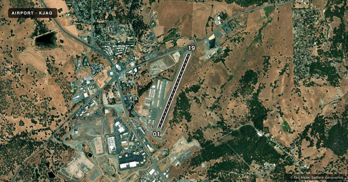
Airport sketch
Runways drawn to scale from FAA survey coordinates, rendered over satellite imagery. Not for navigation.
Approaches & charts
Services on the field
Fuel grades, oxygen, maintenance, ramp storage and lighting — as declared to the FAA by the airport operator.
Fuel & services
- Fuel
- 100LLA
- Oxygen (bottled)
- Not available
- Oxygen (bulk)
- Not available
- Airframe repair
- Not available
- Power plant repair
- Not available
Ramp & ground
- Transient storage
- Tie-down
- Landing fee
- No fee published
- Customs
- Not available
- Lighting schedule
- SEE RMK
- Beacon schedule
- SS-SR
- Beacon
- White / Green (civil land)(WG)
- Wind indicator
- Lighted
- Segmented circle
- Yes
Fuel & FBOs
Cheapest 100LL and Jet A on the field and nearby. Always confirm with the FBO before taxi.
Airport notes
Surface conditions, obstructions, local procedures, lighting outages and other notes published with each FAA cycle.
General notes
- RWY 19 IS PREFERRED RWY.
- FOR CD CTC NORCAL APCH AT 916-361-6874.
Lighting notes
- ACTVT REIL RWY 01 & 19; PAPI RWY 01 & 19; MIRL RWY 01/19; TWY LGTS SS-SR ONLY - CTAF.
Approach & departure obstructions
- 19PAPI RWY 19 UNUSBL BYD 5 DEG L OF CRS.
VFR map & nearby airports
VFR sectional. Tap any ICAO chip to open that airport.
Key facts · KJAQ
Answer card- ICAO
- KJAQ
- Name
- WESTOVER FLD AMADOR COUNTY
- Location
- JACKSON, CALIFORNIA
- Elevation
- 1,693 ft MSL
- Traffic pattern altitude
- 2,693 ft MSL (1,000 AGL)
- Control tower
- Non-towered (use CTAF)
- Total runways
- 1
- Longest runway
- 01/19 · 3,401 ft
- Published ILS approaches
- 0
- Published frequencies
- 6
- Magnetic variation
- 16°
- Current flight rules
- VFR
- Current wind
- 000° at 0 kt
- Favored runway now
- –
Westover Fld Amador County Airport is in Jackson, California. The field elevation is 1,693 ft MSL. It has one runway, 01/19, which is 3,401 ft long and asphalt. The airport is non-towered. Use CTAF 123.075 for local traffic calls. No ILS approaches are published here.
The published pattern altitude is not given, so use the standard 1,000 ft AGL for light piston aircraft unless the current Chart Supplement says otherwise. That puts the pattern at 2,693 ft MSL based on the field elevation. Runway 19 is the preferred runway. The Chart Supplement also notes that the PAPI on runway 19 is unusable beyond 5 degrees left of course. Runway end identifier lights are active on both ends. Medium intensity runway lights are on runway 01/19. Taxiway lights operate from sunset to sunrise only.
Amador County Airport is the on-field FBO. It carries AVGAS 100LL and JET A. Call (209) 223-2376 before arrival if you need current service details. For clearance delivery, contact NorCal Approach at 916-361-6874. This is a mountain foothill airport with a relatively short single runway. Plan performance carefully. Check density altitude, runway length and wind before you go.