METAR & TAF O61
Current METAR
Observed 12:15Z
KO61 271215Z AUTO 00000KT 10SM CLR 14/08 A2997 RMK AO2 T01370079 $
- Wind
- 000° @ 0 kt
- Visibility
- 10 SM
- Temp / Dew
- 14°C / 8°C
- Altimeter
- 29.97 inHg
- Clouds
- CLR
- Density alt
- 1,414 ft
- Ceiling
- Unlimited
- Rules
- VFR
Airport info & contacts
Manager on record, flight service, ARTCC, attendance schedule and pattern altitude — published by the FAA and refreshed every 28 days.
Location
- From city
- 0 NM N
- VFR sectional
- SAN FRANCISCO
- Pattern altitude
- 1,014 ft AGL · 2,301 ft MSL
- ARTCC
- ZOA · OAKLAND
- NOTAM facility
- RIU (NOTAM-D)
Airport manager
- Name
- JOSEPH ZIMLICH
- Phone
- 530-676-8316
- Address
- 3374 MIRA LOMA DRIVE, CAMERON PARK CA 95682
Flight service · Hours
- FSS RIU
- RANCHO MURIETA1-800-WX-BRIEF
- Attendance
- MON-FRI · 0800-1700
Frequencies
Tap any row to copy the frequency to your clipboard.
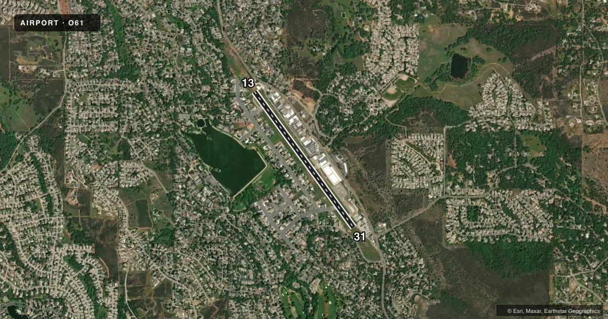
Runways & pattern
Full pagePattern entry · RWY 13
LEFT TRAFFICRunway end performance
| End | TORA | TODA | ASDA | LDA | VGSI | Approach lights | Obstruction |
|---|---|---|---|---|---|---|---|
| 13 | — | — | — | — | — | — | 40', tree, 410' from thr, 125' R of cntrln, slope 10 |
| 31 | — | — | — | — | PSIL(6°) | — | 240', tree, 2190' from thr, 300' R of cntrln, slope 9 |
Declared distances in feet. TORA = takeoff run available, TODA = takeoff distance, ASDA = accelerate-stop, LDA = landing distance.
Airport sketch
Runways drawn to scale from FAA survey coordinates, rendered over satellite imagery. Not for navigation.
Approaches & charts
Services on the field
Fuel grades, oxygen, maintenance, ramp storage and lighting — as declared to the FAA by the airport operator.
Fuel & services
- Fuel
- 100LL
- Oxygen (bottled)
- Not available
- Oxygen (bulk)
- Not available
- Airframe repair
- Major
- Power plant repair
- Major
Ramp & ground
- Transient storage
- Tie-down
- Landing fee
- No fee published
- Customs
- Not available
- Lighting schedule
- SEE RMK
- Wind indicator
- Yes
- Segmented circle
- Yes
Fuel & FBOs
Cheapest 100LL and Jet A on the field and nearby. Always confirm with the FBO before taxi.
Airport notes
Surface conditions, obstructions, local procedures, lighting outages and other notes published with each FAA cycle.
General notes
- FOR NOISE ABATEMENT PROCEDURES CALL AMGR (530) 676-8316
- RY 13/31 WEST SIDE 60 FT GATES IN PERIMETER FENCING TO PROVIDE ACCESS TO RESIDENTIAL AREA FOR RESIDENTS AND INVITED GUESTS.
- RY 13/31 RESTRICTED TO USE BY ACFT WITH LESS THAN A MAXIMUM CERTIFICATED GWT OF 12,500 LBS AND WINGSPAN LESS THAN 50 FT.
- HELICOPTER PARKING NOT AUTHORIZED.
- MIGRATORY GEESE IN VNCTY OF ARPT.
- FOR CD CTC NORCAL APCH AT 916-361-6874.
- DO NOT CONFUSE PARL RESIDENTIAL STREETS ON BOTH SIDES OF ARPT WITH THE RWY.
- 1597 FT HILL UNLGTD .5 NM SE OF ARPT.
Lighting notes
- ACTVT MIRL RY 13/31 - CTAF.
Fuel notes
- 100LLFUEL AVBL 24 HRS BY CREDIT CARD
Runway surface & condition
- 13/31GROSS PAVEMENT STRENGTH ESTIMATED BY OWNER 12500 LBS.
Approach & departure obstructions
- 13+65 FT TREE, 150 FT FROM EOR, 125 FT LEFT OF RWY CENTERLINE
- 31+8 FT GND 200 FT FM EOR.
- 13+4' TERRAIN 100' RIGHT.
- 31TREE 1190' FROM THR.
- 13RWY 13 APCH RATIO 5:1 TO DSPLCD THLD OVER 65 FT TREE 350 FT FROM DSPLCD THRESHOLD.
- 31RY 31 +60 FT TREE 130 FT LEFT 250 FT FM EOR. APCH RATIO 29:1 TO DSPLCD THLD.
Other notes
- THIS AIRPORT HAS BEEN SURVEYED BY THE NATIONAL GEODETIC SURVEY.
VFR map & nearby airports
VFR sectional. Tap any ICAO chip to open that airport.
Key facts · O61
Answer card- ICAO
- O61
- Name
- CAMERON PARK
- Location
- CAMERON PARK, CALIFORNIA
- Elevation
- 1,287.3 ft MSL
- Traffic pattern altitude
- 2,301.3 ft MSL (1,014 AGL)
- Control tower
- Non-towered (use CTAF)
- Total runways
- 1
- Longest runway
- 13/31 · 4,051 ft
- Published ILS approaches
- 0
- Published frequencies
- 2
- Magnetic variation
- 16°
- Current flight rules
- VFR
- Current wind
- 000° at 0 kt
- Favored runway now
- –
Cameron Park Airport sits in Cameron Park, California. Field elevation is 1,287.3 ft MSL. The airport has one runway, 13/31, which is 4,051 ft long and paved. There is no control tower. CTAF and UNICOM are both 123.05. Pattern altitude is 1,014 ft AGL, which is 2,301.3 ft MSL.
No ILS approaches are published here, so plan with the current Chart Supplement and your own IFR or VFR backup. The on-field FBO is Cameron Park Airport. It carries AVGAS 100LL. For clearance delivery, NorCal Approach is listed in the remarks. For noise abatement procedures, call the airport manager before you go. That is worth doing here because the airport sits near residential areas.
A few published remarks matter on a first visit. Runway 13/31 is restricted to aircraft under 12,500 pounds maximum certificated gross weight with a wingspan under 50 feet. There is a 65-foot tree near the departure end of runway 13, plus other terrain and tree obstructions near both ends. Medium intensity runway lighting is activated on runway 13/31 by CTAF. Migratory geese are also reported in the area. There is a 1,597-foot hill unlighted about 0.5 NM southeast of the airport, so pay attention to terrain and climb performance.