METAR & TAF L36
L36 does not publish a METAR.
Showing the nearest reporting station: KMCC (MC CLELLAN AIRFIELD) · 2.1 NM away. Conditions at L36 may differ.
METAR · KMCC
Observed 14:15Z
KMCC 261415Z AUTO 15009KT 10SM CLR 18/13 A2996 RMK AO2
- Wind
- 150° @ 9 kt
- Visibility
- 10 SM
- Temp / Dew
- 18°C / 13°C
- Altimeter
- 29.96 inHg
- Clouds
- CLR
- Density alt
- 367 ft
- Ceiling
- Unlimited
- Rules
- VFR
Airport info & contacts
Manager on record, flight service, ARTCC, attendance schedule and pattern altitude — published by the FAA and refreshed every 28 days.
Location
- From city
- 1 NM S
- VFR sectional
- SAN FRANCISCO
- Pattern altitude
- 800 ft AGL · 846 ft MSL
- ARTCC
- ZOA · OAKLAND
- NOTAM facility
- RIU (NOTAM-D)
Airport manager
- Name
- COY LYLES
- Phone
- 916-991-1725
- Address
- 931 E STREET, RIO LINDA CA 95673
Flight service · Hours
- FSS RIU
- RANCHO MURIETA1-800-WX-BRIEF
- Attendance
- 0800-1700
Frequencies
Tap any row to copy the frequency to your clipboard.
Runways & pattern
Full pagePattern entry · RWY 17
RIGHT TRAFFICRunway end performance
| End | TORA | TODA | ASDA | LDA | VGSI | Approach lights | Obstruction |
|---|---|---|---|---|---|---|---|
| 17 | — | — | — | — | — | — | 60', trees, 915' from thr, 225' R of cntrln, slope 11 |
| 35 | — | — | — | — | — | — | 20', trees, 384' from thr, 50' R of cntrln, slope 9 |
Declared distances in feet. TORA = takeoff run available, TODA = takeoff distance, ASDA = accelerate-stop, LDA = landing distance.
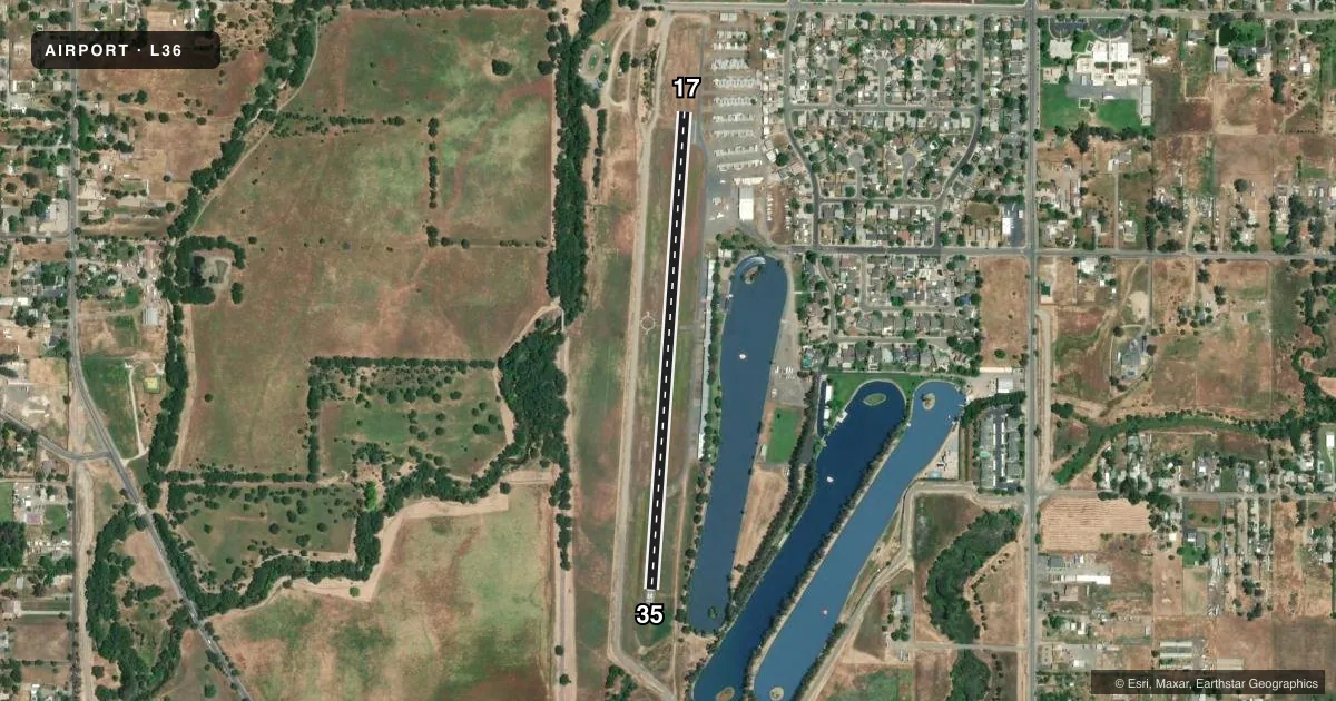
Airport sketch
Runways drawn to scale from FAA survey coordinates, rendered over satellite imagery. Not for navigation.
Approaches & charts
Services on the field
Fuel grades, oxygen, maintenance, ramp storage and lighting — as declared to the FAA by the airport operator.
Fuel & services
- Fuel
- 100LL
- Oxygen (bottled)
- Not available
- Oxygen (bulk)
- Not available
- Airframe repair
- Minor
- Power plant repair
- Minor
- Other services
- INSTR
Ramp & ground
- Transient storage
- Tie-down
- Landing fee
- No fee published
- Customs
- Not available
- Wind indicator
- Lighted
- Segmented circle
- Yes
Fuel & FBOs
Cheapest 100LL and Jet A on the field and nearby. Always confirm with the FBO before taxi.
Airport notes
Surface conditions, obstructions, local procedures, lighting outages and other notes published with each FAA cycle.
General notes
- TOUCH AND GO LANDINGS NOT AUTHORIZED.
- ULTRALIGHTS NOT AUTHORIZED.
- FOR NOISE ABATEMENT RY 17 RIGHT TURN TO HDG 215 DEG AFT TKOF TO AVOID OVERFLIGHT OF SCHOOL.
- TREE LINES EAST, WEST & NORTH OF ARPT - UNLIGHTED.
- FOR CD CTC NORCAL APCH AT 916-361-6874.
- THE ARPT IS CURRENTLY CLSD TO NGT OPS.
Approach & departure obstructions
- 1717/35 NSTD CNTRLN SPACING & WIDTH.
- 35RWY 17 /35 NSTD CNTRLN SPACING & WIDTH.
Other notes
- THIS AIRPORT HAS BEEN SURVEYED BY THE NATIONAL GEODETIC SURVEY.
- 17/35LONGL AND LATERAL CRACKING.
VFR map & nearby airports
VFR sectional. Tap any ICAO chip to open that airport.
Key facts · L36
Answer card- ICAO
- L36
- Name
- RIO LINDA
- Location
- RIO LINDA, CALIFORNIA
- Elevation
- 46 ft MSL
- Traffic pattern altitude
- 846 ft MSL (800 AGL)
- Control tower
- Non-towered (use CTAF)
- Total runways
- 1
- Longest runway
- 17/35 · 2,625 ft
- Published ILS approaches
- 0
- Published frequencies
- 2
- Magnetic variation
- 16°
- Current flight rules
- VFR
- Current wind
- 150° at 9 kt
- Favored runway now
- RWY 17
Rio Linda Airport (L36) sits in Rio Linda, California. Field elevation is 46 ft MSL. It has one runway, 17/35, which is 2,625 ft long and asphalt. The field is not towered. CTAF and UNICOM are both 123.0. Pattern altitude is 800 ft AGL. That puts the pattern at 846 ft MSL.
No ILS approaches are published here. If you need current approach or airspace details, check the current FAA Chart Supplement before you go. The airport is currently closed to night operations. Touch-and-go landings are not authorized. Ultralights are not authorized.
For noise abatement on runway 17, plan a right turn to heading 215 degrees after takeoff so you avoid the school. There are tree lines east, west and north of the airport. They are unlighted, so daylight planning matters. Runways 17 and 35 also have nonstandard centerline spacing and width. The runway surface has longitudinal and lateral cracking.
No on-field FBOs are listed. Contact the airport operator directly before arrival, or call the field on CTAF or UNICOM for current FBO availability. For clearance delivery, contact NorCal Approach at 916-361-6874.