METAR & TAF KEDU
Current METAR
Observed 12:20Z
KEDU 271220Z AUTO 00000KT 10SM 14/13 A2993 RMK AO1
- Wind
- 000° @ 0 kt
- Visibility
- 10 SM
- Temp / Dew
- 14°C / 13°C
- Altimeter
- 29.93 inHg
- Clouds
- Clear
- Density alt
- -46 ft
- Ceiling
- Unlimited
- Rules
- VFR
Airport info & contacts
Manager on record, flight service, ARTCC, attendance schedule and pattern altitude — published by the FAA and refreshed every 28 days.
Location
- From city
- 2 NM W
- VFR sectional
- SAN FRANCISCO
- Pattern altitude
- 800 ft AGL · 870 ft MSL
- ARTCC
- ZOA · OAKLAND
- NOTAM facility
- RIU (NOTAM-D)
Airport manager
- Name
- PERRY H EGGLESTON
- Phone
- 530-752-5435
- Address
- TRANSP & PARKING SERVICES, 1 SHIELDS AVE, DAVIS CA 95616-8724
Flight service · Hours
- FSS RIU
- RANCHO MURIETA1-800-WX-BRIEF
- Attendance
- MON-FRI · 0800-1200
Frequencies
Tap any row to copy the frequency to your clipboard.
Runways & pattern
Full pagePattern entry · RWY 17
LEFT TRAFFICRunway end performance
| End | TORA | TODA | ASDA | LDA | VGSI | Approach lights | Obstruction |
|---|---|---|---|---|---|---|---|
| 17 | — | — | — | — | PAPI 2-box left(3.25°) | — | 40', tree, 1113' from thr, 246' R of cntrln, slope 22 |
| 35 | — | — | — | — | PAPI 2-box left(3.25°) | — | 61', trees, 1431' from thr, 221' R of cntrln, slope 20 |
Declared distances in feet. TORA = takeoff run available, TODA = takeoff distance, ASDA = accelerate-stop, LDA = landing distance.
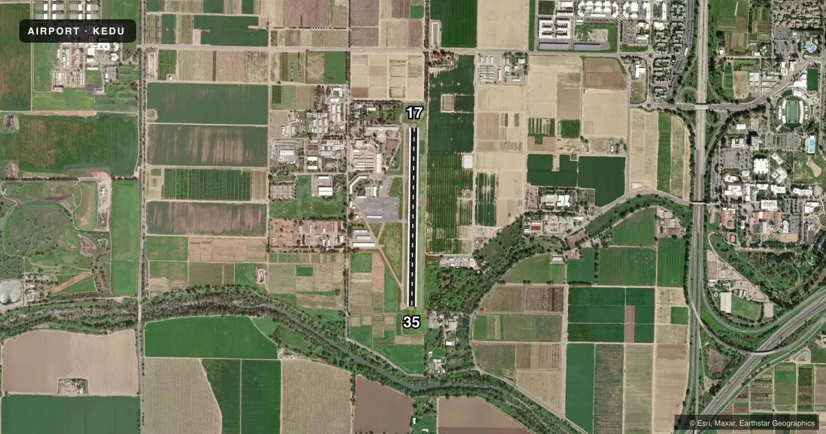
Airport sketch
Runways drawn to scale from FAA survey coordinates, rendered over satellite imagery. Not for navigation.
Approaches & charts
Services on the field
Fuel grades, oxygen, maintenance, ramp storage and lighting — as declared to the FAA by the airport operator.
Fuel & services
- Fuel
- 100LL
- Oxygen (bottled)
- Not available
- Oxygen (bulk)
- Not available
- Airframe repair
- Major
- Power plant repair
- Major
- Other services
- INSTR,RNTL
Ramp & ground
- Transient storage
- Tie-down
- Landing fee
- No fee published
- Customs
- Not available
- Lighting schedule
- SEE RMK
- Beacon schedule
- SS-SR
- Beacon
- White / Green (civil land)(WG)
- Wind indicator
- Lighted
- Segmented circle
- Yes
Fuel & FBOs
Cheapest 100LL and Jet A on the field and nearby. Always confirm with the FBO before taxi.
Airport notes
Surface conditions, obstructions, local procedures, lighting outages and other notes published with each FAA cycle.
General notes
- 65 FT TREES LCTD S SIDE OF CREEK 1257 FT FM THR RWY 35.
- TREES +40 FT, W SIDE OF RWY NEAR RWY 17 THR.
- NOISE ABATEMENT, NOISE SENSITIVE AREA N OF ARPT.
- AFTER HRS EMERG: UC DAVIS POLICE 530-752-1230. AFTER HRS NON-EMERG: UC DAVIS POLICE 530-752-1727.
- CAUTION: REMOTE CTL ACFT WI AREA DEFINED AS 0.5 NM RAD OF 3835N/12142W (5 NM NE EDU), SFC - 1200 FT AGL, SR-SS.
- FOR CD CTC OAKLAND ARTCC AT 510-745-3380.
Lighting notes
- ACTVT REIL RWY 17 & 35; PAPI RWY 17 & 35; MIRL RWY 17/35 - CTAF.
Fuel notes
- 100LLFUEL SELF-SERVICE AVBL 24 HRS.
Runway surface & condition
- 17/35OPNS LTD TO ACFT 12500 LBS OR LESS BY ARPT OWNER.
Other notes
- ESTABD PRIOR TO 15 MAY 59.
VFR map & nearby airports
VFR sectional. Tap any ICAO chip to open that airport.
Key facts · KEDU
Answer card- ICAO
- KEDU
- Name
- UNIVERSITY
- Location
- DAVIS, CALIFORNIA
- Elevation
- 69.5 ft MSL
- Traffic pattern altitude
- 869.5 ft MSL (800 AGL)
- Control tower
- Non-towered (use CTAF)
- Total runways
- 1
- Longest runway
- 17/35 · 3,176 ft
- Published ILS approaches
- 0
- Published frequencies
- 4
- Magnetic variation
- 14°
- Current flight rules
- VFR
- Current wind
- 000° at 0 kt
- Favored runway now
- –
University Airport (KEDU) sits in Davis, California. Field elevation is 69.5 ft MSL. The airport has one runway, 17/35, which is 3,176 ft long. It is an untowered field, so use CTAF 123.075 for local traffic calls. Pattern altitude is 800 ft AGL, which is 869.5 ft MSL.
No ILS approaches are published here. The runway is asphalt. Runway end identifier lights are active on 17 and 35. PAPI is installed on both ends. Medium intensity runway lights are also installed on 17/35. University Airport Services is on the field. It carries 100LL. Self-serve 100LL is available 24 hours.
A first-time pilot should pay attention to the published noise abatement procedures. There is a noise sensitive area north of the airport. The Chart Supplement also notes trees near both runway ends. There are 65-foot trees south of the creek near the threshold of runway 35. There are trees over 40 feet tall near the threshold of runway 17. Operations are limited to aircraft 12,500 pounds gross weight or less by the airport owner. For clearance delivery, contact Oakland ARTCC. Check current airport remarks before you go. Remote controlled aircraft also operate nearby in a defined area northeast of EDU.