METAR & TAF 1O3
1O3 does not publish a METAR.
Showing the nearest reporting station: KSCK (STOCKTON METRO) · 18.6 NM away. Conditions at 1O3 may differ.
METAR · KSCK
Observed 09:55Z
KSCK 270955Z AUTO 32006KT 10SM CLR 16/11 A2994 RMK AO2 SLP138 T01560111 $
- Wind
- 320° @ 6 kt
- Visibility
- 10 SM
- Temp / Dew
- 16°C / 11°C
- Altimeter
- 29.94 inHg
- Clouds
- CLR
- Density alt
- 169 ft
- Ceiling
- Unlimited
- Rules
- VFR
Airport info & contacts
Manager on record, flight service, ARTCC, attendance schedule and pattern altitude — published by the FAA and refreshed every 28 days.
Location
- From city
- 4 NM N
- VFR sectional
- SAN FRANCISCO
- Pattern altitude
- 800 ft AGL · 860 ft MSL
- ARTCC
- ZOA · OAKLAND
- NOTAM facility
- RIU (NOTAM-D)
Airport manager
- Name
- ROBERT KUPKA
- Phone
- 209-369-9126
- Address
- 23987 NORTH HWY 99, ACAMPO CA 95220
Flight service · Hours
- FSS RIU
- RANCHO MURIETA1-800-WX-BRIEF
- Attendance
- 0900-DUSK
Frequencies
Tap any row to copy the frequency to your clipboard.
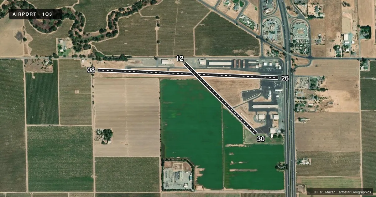
Runways & pattern
Full pagePattern entry · RWY 30
LEFT TRAFFIC| Runway | Heading (°M) | Length | Surface | Traffic |
|---|---|---|---|---|
| 08/26 | 76° / 256° | 3,547 ft | ASPH | 26 R |
| 12/30Favored | 119° / 299° | 1,979 ft | ASPH | 12 R |
Runway end performance
| End | TORA | TODA | ASDA | LDA | VGSI | Approach lights | Obstruction |
|---|---|---|---|---|---|---|---|
| 08 | — | — | — | — | — | — | 35', pole, 50' from thr, 165' R of cntrln, slope 1 |
| 26 | — | — | — | — | — | — | 30', pole, 340' from thr, 90' R of cntrln, slope 4 |
| 12 | — | — | — | — | — | — | 35', tree, 660' from thr, 80' R of cntrln, slope 13 |
| 30 | — | — | — | — | — | — | 40', tree, 750' from thr, 160' R of cntrln, slope 13 |
Declared distances in feet. TORA = takeoff run available, TODA = takeoff distance, ASDA = accelerate-stop, LDA = landing distance.
Airport sketch
Runways drawn to scale from FAA survey coordinates, rendered over satellite imagery. Not for navigation.
Approaches & charts
Services on the field
Fuel grades, oxygen, maintenance, ramp storage and lighting — as declared to the FAA by the airport operator.
Fuel & services
- Fuel
- 100LLA
- Oxygen (bottled)
- High pressure
- Oxygen (bulk)
- Not available
- Airframe repair
- Major
- Power plant repair
- Major
- Other services
- INSTR,PAJA,RNTL,SALES,SURV
Ramp & ground
- Transient storage
- Tie-down
- Landing fee
- No fee published
- Customs
- Not available
- Lighting schedule
- SS-SR
- Beacon schedule
- SS-SR
- Beacon
- White / Green (civil land)(WG)
- Wind indicator
- Yes
- Segmented circle
- Yes
Fuel & FBOs
Cheapest 100LL and Jet A on the field and nearby. Always confirm with the FBO before taxi.
Airport notes
Surface conditions, obstructions, local procedures, lighting outages and other notes published with each FAA cycle.
General notes
- PARACHUTE DROP ZONE LOCATED APPROXIMATLY 1000' SOUTH OF RWY 08/26.
- FOR CD CTC NORCAL APCH AT 916-361-0516.
Fuel notes
- 100LLAUTOMATED CREDIT CARD FUEL SYSTEM 24 HRS DAY.
Runway surface & condition
- 08/26RWY 08/26 NSTD LIRL LCTD 30 FT FM PAVEMENT EDGE. END OF RUNWAY LIGHTS LOCATED AT BOTH DISPLACED THRESHOLDS TO RUNWAY 8/26.
Approach & departure obstructions
- 08RWY 8 35 FT POLE 100 FT FM RSY END 165 FT RIGHT.
- 12RY 12 +15 FT ROAD 125 FT-150 FT FM RWY END 25 FT RIGHT 75 FT LEFT.
- 26RY 26 +15' FRONTAGE ROAD 110 FM RY END AND +20' FREEWAY 150' FM RY END. ALL 125' R - 125' L.
- 08RWY 8 APCH RATIO 17:1 FROM DSPLCD THR.
- 26APCH RATIO 27:1 FM DSPLCD THR; APCH RATIO FM DSPLCD THR TO +58 FT ANTENNA 1400 FT FM DSPLCD THR 24:1.
- 30RWY 30 APCH RATIO 20:1 FROM DSPLCD THR.
Other notes
- PREDATES 1958 FA ACT.
VFR map & nearby airports
VFR sectional. Tap any ICAO chip to open that airport.
Key facts · 1O3
Answer card- ICAO
- 1O3
- Name
- LODI
- Location
- LODI, CALIFORNIA
- Elevation
- 59.9 ft MSL
- Traffic pattern altitude
- 859.9 ft MSL (800 AGL)
- Control tower
- Non-towered (use CTAF)
- Total runways
- 2
- Longest runway
- 08/26 · 3,547 ft
- Published ILS approaches
- 0
- Published frequencies
- 7
- Magnetic variation
- 16°
- Current flight rules
- VFR
- Current wind
- 320° at 6 kt
- Favored runway now
- RWY 30
Lodi Airport sits in Lodi, California at 59.9 ft MSL. It has two asphalt runways. The longest is runway 08/26 at 3,547 ft. The field is non-towered, so pilots should plan for self-announce traffic on CTAF 122.9 and coordinate with NorCal when needed. No ILS approaches are published here.
Pattern altitude is 800 ft AGL, which is 859.9 ft MSL. That is the number to use for local pattern work. Runway 08/26 has low-intensity lighting with the lights set 30 ft from the pavement edge. The displaced thresholds also have end lights. Published remarks also note obstructions near both ends of the field. Runway 8 has a 35 ft pole near the runway safety area. Runway 26 has a frontage road and freeway close to the departure end. Runway 12 also has a road near the end of the runway.
Lodi Airport has one on-field FBO. Lodi Airport carries 100LL and Jet A. It also has an automated credit card fuel system available 24 hours a day. A parachute drop zone sits about 1,000 ft south of runway 08/26. For clearance delivery, contact NorCal Approach at 916-361-0516. Pilots should also keep the published runway lighting and obstruction notes in mind when planning night ops or short-field work.