METAR & TAF KRIU
KRIU does not publish a METAR.
Showing the nearest reporting station: KMHR (SACRAMENTO MATHER) · 10.0 NM away. Conditions at KRIU may differ.
METAR · KMHR
Observed 05:35Z
KMHR 270535Z AUTO 13008KT 10SM CLR 18/11 A2995 RMK AO2 T01760109 $
- Wind
- 130° @ 8 kt
- Visibility
- 10 SM
- Temp / Dew
- 18°C / 11°C
- Altimeter
- 29.95 inHg
- Clouds
- CLR
- Density alt
- 502 ft
- Ceiling
- Unlimited
- Rules
- VFR
Airport info & contacts
Manager on record, flight service, ARTCC, attendance schedule and pattern altitude — published by the FAA and refreshed every 28 days.
Location
- From city
- 1 NM W
- VFR sectional
- SAN FRANCISCO
- Pattern altitude
- 800 ft AGL · 944 ft MSL
- ARTCC
- ZOA · OAKLAND
- NOTAM facility
- RIU (NOTAM-D)
Airport manager
- Name
- STAN BUSCOMBE
- Phone
- 916-354-2940
- Address
- 7443 MURIETA DR., RANCHO MURIETA CA 95683
Flight service · Hours
- FSS RIU
- RANCHO MURIETA1-800-WX-BRIEF
- Attendance
- 0800-1700
Frequencies
Tap any row to copy the frequency to your clipboard.
Runways & pattern
Full pagePattern entry · RWY 04
RIGHT TRAFFICRunway end performance
| End | TORA | TODA | ASDA | LDA | VGSI | Approach lights | Obstruction |
|---|---|---|---|---|---|---|---|
| 04 | — | — | — | — | VASI 2-box left(3°) | — | 8', road, 222' from thr, 0' R of cntrln, slope 2 |
| 22 | — | — | — | — | VASI 2-box left(3°) | — | 95', tree, 2370' from thr, 225' R of cntrln, slope 22 |
Declared distances in feet. TORA = takeoff run available, TODA = takeoff distance, ASDA = accelerate-stop, LDA = landing distance.
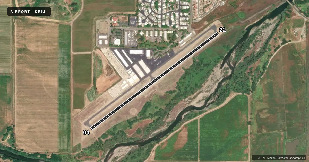
Airport sketch
Runways drawn to scale from FAA survey coordinates, rendered over satellite imagery. Not for navigation.
Approaches & charts
Services on the field
Fuel grades, oxygen, maintenance, ramp storage and lighting — as declared to the FAA by the airport operator.
Fuel & services
- Fuel
- 100LLA
- Oxygen (bottled)
- Not available
- Oxygen (bulk)
- Not available
- Airframe repair
- Not available
- Power plant repair
- Not available
- Other services
- INSTR,RNTL
Ramp & ground
- Transient storage
- Tie-down
- Hangar
- Landing fee
- Yes
- Lighting schedule
- SEE RMK
- Wind indicator
- Lighted
- Segmented circle
- Yes
Fuel & FBOs
Cheapest 100LL and Jet A on the field and nearby. Always confirm with the FBO before taxi.
Airport notes
Surface conditions, obstructions, local procedures, lighting outages and other notes published with each FAA cycle.
General notes
- ALL TNSNT ACFT RQRD TO PARK IN DSGND TSNT AREA.
- DEER ON & INVOF RWY
- +30 FT OBS LIT POWER POLES PARALLEL TO RY 04/22.
- ALL ULTRALIGHTS MUST COMPLY WITH FAR 103 AND HAVE AN OPERATING ACFT RADIO.
- RY 22 NOISE ABATEMENT PROCEDURES IN EFFECT, CTC AMGR 916-354-2940.
- FOR CD CTC NORCAL APCH AT 916-361-6874.
- INTERSECTION TKOFS PROHIBITED
- FSLS ONLY: NO TGLS ALLOWED.
Lighting notes
- 0800-1700
Approach & departure obstructions
- 04VASI OTS INDEFLY.
- 22VASI OTS INDEFLY.
Other notes
- VFR ONLY-TFC PAT TO NW.
- LNDG FEES APPLY: PSTN SNGL $25, PSTN TWIN $40, TURBO PROP $75, JET $100.
VFR map & nearby airports
VFR sectional. Tap any ICAO chip to open that airport.
Key facts · KRIU
Answer card- ICAO
- KRIU
- Name
- RANCHO MURIETA
- Location
- RANCHO MURIETA, CALIFORNIA
- Elevation
- 144.2 ft MSL
- Traffic pattern altitude
- 944.2 ft MSL (800 AGL)
- Control tower
- Non-towered (use CTAF)
- Total runways
- 1
- Longest runway
- 04/22 · 3,798 ft
- Published ILS approaches
- 0
- Published frequencies
- 2
- Magnetic variation
- 16°
- Current flight rules
- VFR
- Current wind
- 130° at 8 kt
- Favored runway now
- RWY 04
Rancho Murieta Airport sits in Rancho Murieta, California. Field elevation is 144.2 ft MSL. The airport has one runway. Runway 04/22 is 3,798 ft long and asphalt. There is no control tower. CTAF and UNICOM are both 122.8. No ILS approaches are published.
Pattern altitude is 800 ft AGL, which is 944.2 ft MSL. The field uses a northwest traffic pattern. This is VFR only. Full stop landings only are allowed. No touch-and-go landings are allowed. Runway 22 has published noise abatement procedures. Contact the airport manager before arrival if you need the current details. There are also more than 30-foot lighted power poles parallel to runway 04/22. Deer are reported on and near the runway, so keep your scan up on short final and during rollout.
Rancho Murieta Airport has one on-field FBO. Rancho Murieta Airport carries AVGAS 100LL and JET A. Transient aircraft must park in the designated transient area. Lighting is available from 0800 to 1700. For clearance delivery, contact NorCal Approach at 916-361-6874. If you are planning a first stop here, check the current FAA Chart Supplement for any updates on procedures before you go.