METAR & TAF O88
O88 does not publish a METAR.
Showing the nearest reporting station: KVCB (NUT TREE) · 16.4 NM away. Conditions at O88 may differ.
METAR · KVCB
Observed 10:53Z
KVCB 271053Z AUTO 23007KT 10SM CLR 17/11 A2992 RMK AO2 SLP131 T01670111
- Wind
- 230° @ 7 kt
- Visibility
- 10 SM
- Temp / Dew
- 17°C / 11°C
- Altimeter
- 29.92 inHg
- Clouds
- CLR
- Density alt
- 268 ft
- Ceiling
- Unlimited
- Rules
- VFR
Airport info & contacts
Manager on record, flight service, ARTCC, attendance schedule and pattern altitude — published by the FAA and refreshed every 28 days.
Location
- From city
- 3 NM NW
- VFR sectional
- SAN FRANCISCO
- ARTCC
- ZOA · OAKLAND
- NOTAM facility
- RIU (NOTAM-D)
Airport manager
- Name
- TOM HAVENS
- Phone
- 707-249-7510
- Address
- ONE MAIN STREET, P.O. BOX 94571, RIO VISTA CA 94571
Flight service · Hours
- FSS RIU
- RANCHO MURIETA1-800-WX-BRIEF
- Attendance
- MON-THUR · 0800 - 1700
Frequencies
Tap any row to copy the frequency to your clipboard.
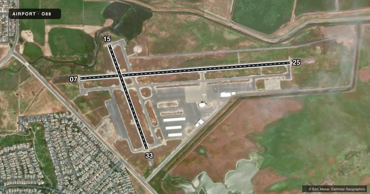
Runways & pattern
Full pagePattern entry · RWY 25
RIGHT TRAFFIC| Runway | Heading (°M) | Length | Surface | Traffic |
|---|---|---|---|---|
| 07/25Favored | 72° / 252° | 4,199 ft | ASPH | 25 R |
| 15/33 | 146° / 326° | 2,199 ft | ASPH | 33 R |
Runway end performance
| End | TORA | TODA | ASDA | LDA | VGSI | Approach lights | Obstruction |
|---|---|---|---|---|---|---|---|
| 07 | — | — | — | — | PAPI 2-box left(4°) | — | — |
| 25 | — | — | — | — | PAPI 2-box left(4°) | — | — |
| 15 | — | — | — | — | PAPI 2-box left(4°) | — | 25', pole, 1365' from thr, 0' R of cntrln, slope 46 |
Declared distances in feet. TORA = takeoff run available, TODA = takeoff distance, ASDA = accelerate-stop, LDA = landing distance.
Airport sketch
Runways drawn to scale from FAA survey coordinates, rendered over satellite imagery. Not for navigation.
Approaches & charts
Services on the field
Fuel grades, oxygen, maintenance, ramp storage and lighting — as declared to the FAA by the airport operator.
Fuel & services
- Fuel
- 100LL
- Other services
- AGRI,INSTR,RNTL,SALES
Ramp & ground
- Transient storage
- Tie-down
- Landing fee
- No fee published
- Lighting schedule
- SEE RMK
- Beacon schedule
- SS-SR
- Beacon
- White / Green (civil land)(WG)
- Wind indicator
- Lighted
- Segmented circle
- Yes
Fuel & FBOs
Cheapest 100LL and Jet A on the field and nearby. Always confirm with the FBO before taxi.
Airport notes
Surface conditions, obstructions, local procedures, lighting outages and other notes published with each FAA cycle.
General notes
- RY 25 CALM WIND RY.
- NOISE SENSITIVE AREA N OF RY 33. DO NOT OVERFLY RANCH & CORRALS OFF RY 33. ALL RYS CLIMB TO 700 FT BEFORE TURNS.
- HELIPAD: NO AUTOROTATIONS HOVERING AUTO'S OR RUNNING LDGS TO PAVEMENT.
- HEL TFC TO HELIPAD REMAIN SOUTH OF ARPT 500 FT.
- WHEN WIND FAVORS RWY 15/33 HELS MAY USE APRON AREA WEST OF RWY 15/33; REMAIN WEST OF ARPT 500 FT.
- FOR CD CTC OAKLAND ARTCC AT 510-745-3380.
Lighting notes
- ACTVT REIL RWY 07, 15, 25, & 33; PAPI RWY 07, 15, & 25; MIRL RWY 07/25 & 15/33; PERIMETER H1 - CTAF.
Fuel notes
- 100LLFAST PAY FUEL SYSTEM AVBL 24 HRS.
Other notes
- MANAGERLEAD MAINTENANCE SUPERVISOR
- MANAGERAFTER HOURS CALL (707) 249-7510
VFR map & nearby airports
VFR sectional. Tap any ICAO chip to open that airport.
Key facts · O88
Answer card- ICAO
- O88
- Name
- RIO VISTA MUNI
- Location
- RIO VISTA, CALIFORNIA
- Elevation
- 22.5 ft MSL
- Traffic pattern altitude
- 1,022.5 ft MSL (1,000 AGL)
- Control tower
- Non-towered (use CTAF)
- Total runways
- 2
- Longest runway
- 07/25 · 4,199 ft
- Published ILS approaches
- 0
- Published frequencies
- 5
- Magnetic variation
- 14°
- Current flight rules
- VFR
- Current wind
- 230° at 7 kt
- Favored runway now
- RWY 25
Rio Vista Muni sits in Rio Vista, California at 22.6 ft MSL. It has two asphalt runways. The longest is runway 07/25 at 4,199 ft. Runway 15/33 is 2,199 ft. There is no control tower, so plan on CTAF 122.725 and standard non-towered procedures unless ATC gives you something different. No ILS approaches are published here.
The pattern altitude is not published. For a light piston, use the standard 1,000 ft AGL unless the current FAA Chart Supplement or local procedures say otherwise. That puts you at about 1,023 ft MSL based on the field elevation. The airport sits in the Delta area, so watch wind shifts and keep an eye on the runway choice. The published remarks say runway 25 is the calm wind runway.
There is one on-field FBO. Rio Vista Municipal Airport carries 100LL. Fast pay fuel is available 24 hours for 100LL. The field also has lighting on both runways, plus PAPI and runway end identifier lights on 07, 15, 25 and 33. The published remarks call out a noise sensitive area north of runway 33. Do not overfly the ranch and corrals off runway 33. All runways require climb to 700 feet before turns. Helicopter traffic has separate routing and altitude notes, so brief that carefully before arrival.