METAR & TAF C83
Current METAR
Observed 00:55Z
KC83 270055Z AUTO 23023KT 10SM CLR 30/10 A2992 RMK AO2
- Wind
- 230° @ 23 kt
- Visibility
- 10 SM
- Temp / Dew
- 30°C / 10°C
- Altimeter
- 29.92 inHg
- Clouds
- CLR
- Density alt
- 1,897 ft
- Ceiling
- Unlimited
- Rules
- VFR
Airport info & contacts
Manager on record, flight service, ARTCC, attendance schedule and pattern altitude — published by the FAA and refreshed every 28 days.
Location
- From city
- 2 NM S
- VFR sectional
- SAN FRANCISCO
- ARTCC
- ZOA · OAKLAND
- NOTAM facility
- OAK (NOTAM-D)
Airport manager
- Name
- GREG BAER
- Phone
- 925-608-8000
- Address
- 181 JOHN GLENN DR, SUITE 100, CONCORD CA 94250
Flight service · Hours
- FSS OAK
- OAKLAND1-800-WX-BRIEF
- Attendance
- 0700-1400
Frequencies
Tap any row to copy the frequency to your clipboard.
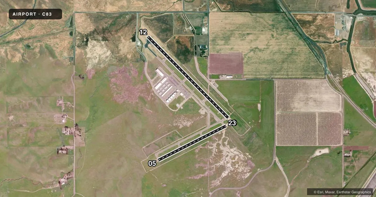
Runways & pattern
Full pagePattern entry · RWY 23
LEFT TRAFFIC| Runway | Heading (°M) | Length | Surface | Traffic |
|---|---|---|---|---|
| 12/30 | 120° / 300° | 4,500 ft | ASPH | 30 R |
| 05/23Favored | 48° / 228° | 3,000 ft | ASPH | 05 R |
Runway end performance
| End | TORA | TODA | ASDA | LDA | VGSI | Approach lights | Obstruction |
|---|---|---|---|---|---|---|---|
| 12 | — | — | — | — | — | — | 61', pole, 1591' from thr, 261' R of cntrln, slope 22 |
| 30 | — | — | — | — | PAPI 2-box left(3.5°) | — | 65', hill, 3218' from thr, 729' R of cntrln, slope 46 |
| 23 | — | — | — | — | PAPI 2-box left(3.5°) | — | — |
Declared distances in feet. TORA = takeoff run available, TODA = takeoff distance, ASDA = accelerate-stop, LDA = landing distance.
Airport sketch
Runways drawn to scale from FAA survey coordinates, rendered over satellite imagery. Not for navigation.
Approaches & charts
Services on the field
Fuel grades, oxygen, maintenance, ramp storage and lighting — as declared to the FAA by the airport operator.
Fuel & services
- Fuel
- 100LL
- Other services
- GLD,PAJA,TOW
Ramp & ground
- Transient storage
- Tie-down
- Lighting schedule
- SEE RMK
- Beacon schedule
- SS-SR
- Beacon
- White / Green (civil land)(WG)
- Segmented circle
- Yes
Fuel & FBOs
Cheapest 100LL and Jet A on the field and nearby. Always confirm with the FBO before taxi.
Airport notes
Surface conditions, obstructions, local procedures, lighting outages and other notes published with each FAA cycle.
General notes
- ULTRALIGHT & SAILPLANE ACTIVITY ON & INVOF ARPT.
- RISING TERRAIN WITH NUMEROUS WINDMILLS ON RIDGES WEST OF ARPT.
- HANGAR APRON & TIEDOWN APRON 12500 LBS MAX.
- RY 30 CALM WIND RY.
- 200' TOWER 5600 FEET FROM RUNWAY 05.
- 100' TOWER 5100 FEET FROM RUNWAY 23.
- POWER PLANT 2.7 MILES SE OF AIRPORT PRODUCING THERMAL PLUMES; AVOID OVERLFIGHT BELOW 1,500 FT AGL.
- FOR CD CTC NORCAL APCH AT 916-361-0516.
- FREQ UAS DRONE ACT 7.8 NM DIAM ARND FLD UP TO 8000 FT.
- PRCHT ACT AT NW END OF ARPT.
Lighting notes
- PCL AVBL SS-SR. ACTVT REIL RWY 30; MIRL RWY 12/30 & 05/23 - CTAF.
Fuel notes
- 100LLFUEL AVBL 24 HRS BY CREDIT CARD.
Approach & departure obstructions
- 05WIND TURBINES
Other notes
- THIS AIRPORT HAS BEEN SURVEYED BY THE NATIONAL GEODETIC SURVEY.
- MANAGERDIRECTOR OF ARPTS CONTRA COSTA COUNTY.
VFR map & nearby airports
VFR sectional. Tap any ICAO chip to open that airport.
Key facts · C83
Answer card- ICAO
- C83
- Name
- BYRON
- Location
- BYRON, CALIFORNIA
- Elevation
- 78.5 ft MSL
- Traffic pattern altitude
- 1,078.5 ft MSL (1,000 AGL)
- Control tower
- Non-towered (use CTAF)
- Total runways
- 2
- Longest runway
- 12/30 · 4,500 ft
- Published ILS approaches
- 0
- Published frequencies
- 4
- Magnetic variation
- 15°
- Current flight rules
- VFR
- Current wind
- 230° at 23 kt
- Favored runway now
- RWY 23
Byron Airport sits in Byron, California at 78.5 ft MSL. It has two asphalt runways. The longest is 4,500 ft on 12/30. The field is non-towered. CTAF and UNICOM are both 123.05. NORCAL approach and departure use 123.85 or 278.3.
No ILS approaches are published here. Pattern altitude is not published. Use the standard 1,000 ft AGL for light piston traffic unless the current Chart Supplement says otherwise. The on-field FBO is Byron Airport. It carries 100LL. Fuel is available 24 hours by credit card.
A few local items matter on a first visit. Runway 30 is the calm wind runway. Pilot controlled lighting is available from sunset to sunrise. REIL is on runway 30. MIRL is on both runways and is activated on CTAF. There is drone activity within a 7.8 NM diameter around the field up to 8,000 ft. Ultralight and sailplane activity also occurs on and near the airport. A 100-foot tower sits 5,100 ft from runway 23. A 200-foot tower sits 5,600 ft from runway 05. Rising terrain with windmills is west of the airport. A power plant 2.7 miles southeast can create thermal plumes. Avoid low overflight below 1,500 ft AGL in that area.