METAR & TAF KCCR
Current METAR
Observed 12:53Z
KCCR 271253Z AUTO 19013G20KT 10SM CLR 15/12 A2998 RMK AO2 SLP138 T01500122
- Wind
- 190° @ 13G20 kt
- Visibility
- 10 SM
- Temp / Dew
- 15°C / 12°C
- Altimeter
- 29.98 inHg
- Clouds
- CLR
- Density alt
- -43 ft
- Ceiling
- Unlimited
- Rules
- VFR
Airport info & contacts
Manager on record, flight service, ARTCC, attendance schedule and pattern altitude — published by the FAA and refreshed every 28 days.
Location
- From city
- 1 NM W
- VFR sectional
- SAN FRANCISCO
- ARTCC
- ZOA · OAKLAND
- NOTAM facility
- CCR (NOTAM-D)
Airport manager
- Name
- GREG BAER
- Phone
- 925-608-8000
- Address
- 181 JOHN GLENN DR, SUITE 100, CONCORD CA 94520
Flight service · Hours
- FSS OAK
- OAKLAND1-800-WX-BRIEF
- Attendance
- 0700-1700
Frequencies
Tap any row to copy the frequency to your clipboard.
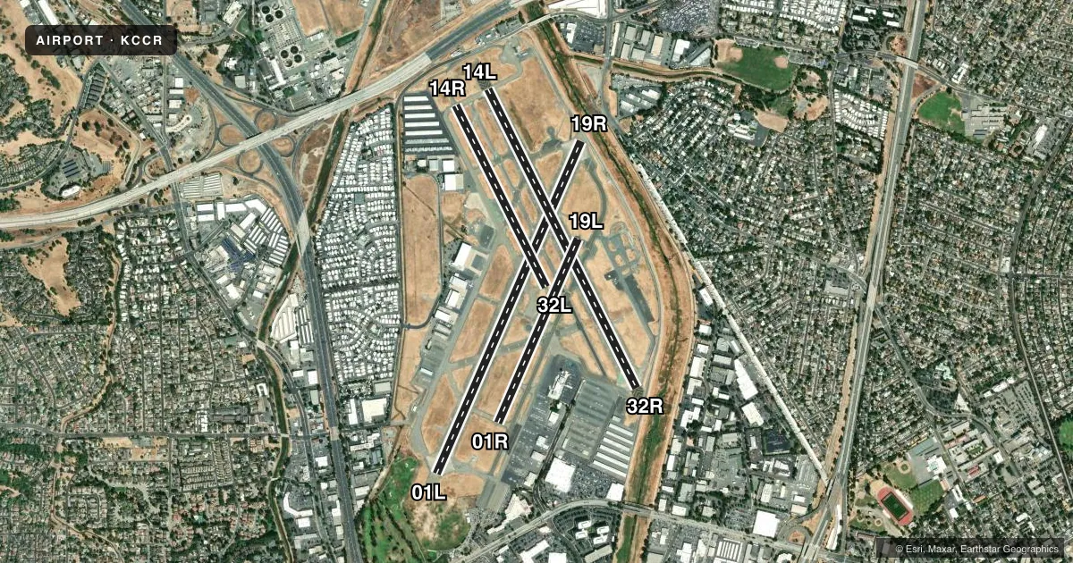
Runways & pattern
Full pagePattern entry · RWY 19R
RIGHT TRAFFIC| Runway | Heading (°M) | Length | Surface | Traffic |
|---|---|---|---|---|
| 01L/19RFavored | 11° / 191° | 5,001 ft | ASPH-CONC | 19R R |
| 14L/32R | 141° / 321° | 4,602 ft | ASPH-CONC | 32R R |
| 14R/32L | 141° / 321° | 2,798 ft | ASPH | 14R R |
| 01R/19L | 11° / 191° | 2,770 ft | ASPH | 01R R |
Runway end performance
| End | TORA | TODA | ASDA | LDA | VGSI | Approach lights | Obstruction |
|---|---|---|---|---|---|---|---|
| 01L | 4,701' | 5,001' | 4,401' | 4,401' | PAPI 4-box left(4°) | — | 58', tree, 1480' from thr, 550' R of cntrln, slope 22 |
| 19R | 5,001' | 5,001' | 5,001' | 4,401' | PAPI 4-box left(3°) | MALS | 44', pole, 900' from thr, 590' R of cntrln, slope 15 |
| 14L | 4,601' | 4,601' | 4,001' | 3,701' | — | — | 15', road, 850' from thr, slope 43 |
| 32R | 4,601' | 5,081' | 4,481' | 4,131' | PAPI 4-box right(4°) | — | 32', tree, 1335' from thr, 225' R of cntrln, slope 35 |
| 14R | 2,799' | 2,799' | 2,799' | 2,799' | — | — | 15', road, 580' from thr, slope 25 |
| 32L | 2,799' | 2,799' | 2,799' | 2,799' | — | — | 46', other, 1260' from thr, 175' R of cntrln, slope 23 |
| 01R | 2,770' | 2,770' | 2,770' | 2,770' | — | — | 50', tree, 1675' from thr, 150' R of cntrln, slope 30 |
| 19L | 2,770' | 2,770' | 2,770' | 2,770' | — | — | 69', tree, 2000' from thr, 257' R of cntrln, slope 26 |
Declared distances in feet. TORA = takeoff run available, TODA = takeoff distance, ASDA = accelerate-stop, LDA = landing distance.
Airport sketch
Runways drawn to scale from FAA survey coordinates, rendered over satellite imagery. Not for navigation.
Approaches & charts
ILS · 1
Services on the field
Fuel grades, oxygen, maintenance, ramp storage and lighting — as declared to the FAA by the airport operator.
Fuel & services
- Fuel
- 100LLA1+UL94
- Oxygen (bottled)
- Not available
- Oxygen (bulk)
- HIGH/LOW
- Airframe repair
- Major
- Power plant repair
- Major
- Other services
- AMB,AVNCS,CHTR,INSTR,RNTL,SALES
Ramp & ground
- Transient storage
- Tie-down
- Landing fee
- No fee published
- Customs
- Not available
- Lighting schedule
- SEE RMK
- Beacon schedule
- SS-SR
- Beacon
- White / Green (civil land)(WG)
- Wind indicator
- Lighted
- Segmented circle
- Yes
Fuel & FBOs
Cheapest 100LL and Jet A on the field and nearby. Always confirm with the FBO before taxi.
Airport notes
Surface conditions, obstructions, local procedures, lighting outages and other notes published with each FAA cycle.
General notes
- NOISE SENSITIVE AREA PRACTICE NOISE ABATEMENT (FLY QUIET) PROCS.
- LNDG FEE FOR COML OPNS & TIE DOWN FEE FOR OVERNIGHT PARKING.
- +8 FT FENCE 110 FT BYD RY 01L TODA DSTC OF 5010 AND +7 FT FENCE 210 FT BYD RY 14L TODA DSTC OF 4601 FT ALONG THE EXTDD RY CNTRL.
- ARPT HAS NOISE ABATEMENT PROCS; CTC AMGR PRIOR TO ARR 925-608-8000.
- BIRDS ON & INVOF ARPT HEAVIEST CONCENTRATION NOV-MAR AND AFTER RAINSTORMS.
- WHEN ATCT CLSD RYS 14L/32R; 14R/32L & 01R/19L CLSD.
- NO TRAINING OPERATIONS MON-FRI 2200-0700; SAT SUN & HOL 2200-0800.
- ARFF SVC AVBL UPON REQ WITH 24 HR NTC.
- WHEN ATCT CLSD CALL TRAVIS APCH CTL (SUU) CLNC DEL 707-424-5111.
- ARPT SFC CONDS NOT MNT 2200-0700.
- CONTRA COSTA CO SUPVRS OF ARPT OPS, BUCHANAN FLD AND BYRON ARPTS, OFC CTC NR 925-608-8000.
Lighting notes
- ACTVT MALS RWY 19R 2200-0600; PAPI RWY 01L, 19R, & 32R - 119.7. REIL RWY 01L OFF WHEN ATCT CLSD.
Runway surface & condition
- 01L/19RPCR VALUE: 330/F/C/X/T
- 14L/32RPCR VALUE: 330/F/C/X/T
- 01R/19LRWY 01R/19L NOT AVBL FOR PART 121/PART 380 OPS WITH SKED PAX CARRYING OPS MORE THAN 9 PAX SEATS AND NON-SKED PAX CARRYING OPS MORE THAN 30 PAX SEATS.
- 14R/32LRWY 14R/32L NOT AVBL FOR PART 121/PART 380 OPS WITH SKED PAX CARRYING OPS MORE THAN 9 PAX SEATS AND NON-SKED PAX CARRYING OPS MORE THAN 30 PAX SEATS.
Approach & departure obstructions
- 01LRWY 01L CLOSE IN OBSTN +8 FT FENCE 110 FT FROM RWY END, 100 FT RT
- 19RSTD LEFT TFC WHEN ATCT CLSD.
- 01LPAPI DOES NOT PROVIDE OBSTRUCTION CLEARANCE BYD 4.0 NM FROM THR.
- 32RPAPI DOES NOT PROVIDE OBSTRUCTION CLEARANCE BYD 4.0 NM FROM THR.
- 14LAPCH RATIO 50:1 TO DSPLCD THR.
- 32RAPCH RATIO 50:1 TO DSPLCD THR.
- 14RLIGHT
Other notes
- CLSD TO ACR OPNS WITH MORE THAN 30 PSGR SEATS EXC PPR; CALL AMGR (925) 681-4200. ARFF SVCS AVBL 24 HRS WITH PRIOR APVL FROM ARPT ADMIN.
- 01R/19LRWY 01R/19L PAVEMENT HAS HIGH SEVERITY BLOCK CRACKING, LONGL AND TRANSVERSE CRACKING, PATCHING, AND WEATHERING.
VFR map & nearby airports
VFR sectional. Tap any ICAO chip to open that airport.
Key facts · KCCR
Answer card- ICAO
- KCCR
- Name
- BUCHANAN FLD
- Location
- CONCORD, CALIFORNIA
- Elevation
- 25.6 ft MSL
- Traffic pattern altitude
- 1,025.6 ft MSL (1,000 AGL)
- Control tower
- Towered · 0700-2200
- Total runways
- 4
- Longest runway
- 01L/19R · 5,001 ft
- Published ILS approaches
- 1
- Published frequencies
- 11
- Magnetic variation
- 13°
- Current flight rules
- VFR
- Current wind
- 190° at 13 kt
- Favored runway now
- RWY 19R
Buchanan Field Airport sits in Concord, California. The field elevation is 25.6 ft MSL. It has 4 runways. The longest is 5,001 ft. The tower is open daily from 0700 to 2200. There is 1 ILS approach to runway 19R.
For pattern work, the published pattern altitude is not listed. Use the standard 1,000 ft AGL for light piston traffic unless ATC or the current Chart Supplement says otherwise. The airport is busy and noise sensitive. Published noise abatement procedures are in effect. Check the current Chart Supplement and call the airport manager before arrival if you need the latest details.
Pacific States Aviation is on the field. It carries AVGAS 100LL, JET A, JET A PRIST and UL94. Concord Jet Center is also on the field. It carries JET A and JET A PRIST. When the tower is closed, runways 14L/32R, 14R/32L and 01R/19L are closed. Birds are a factor here, especially from November through March and after rain. There is also a light obstruction near runway 14R. If you are flying a larger aircraft, note that the airport has runway use limits for some passenger-carrying operations. Confirm those details with the current Chart Supplement or the airport operator before you go.