METAR & TAF KHWD
Current METAR
Observed 12:54Z
KHWD 271254Z AUTO 25009KT 10SM OVC011 15/13 A3002 RMK AO2 SLP176 T01500128
- Wind
- 250° @ 9 kt
- Visibility
- 10 SM
- Temp / Dew
- 15°C / 13°C
- Altimeter
- 30.02 inHg
- Clouds
- OVC
- Density alt
- -59 ft
- Ceiling
- 1,100 ft AGL
- Rules
- MVFR
Airport info & contacts
Manager on record, flight service, ARTCC, attendance schedule and pattern altitude — published by the FAA and refreshed every 28 days.
Location
- From city
- 2 NM W
- VFR sectional
- SAN FRANCISCO
- ARTCC
- ZOA · OAKLAND
- NOTAM facility
- HWD (NOTAM-D)
Airport manager
- Name
- DOUG MCNEELEY
- Phone
- (510) 293-8678
- Address
- 20301 SKYWEST DR, HAYWARD CA 94541-4699
Flight service · Hours
- FSS OAK
- OAKLAND1-800-WX-BRIEF
- Attendance
- 0800-1700
Frequencies
Tap any row to copy the frequency to your clipboard.
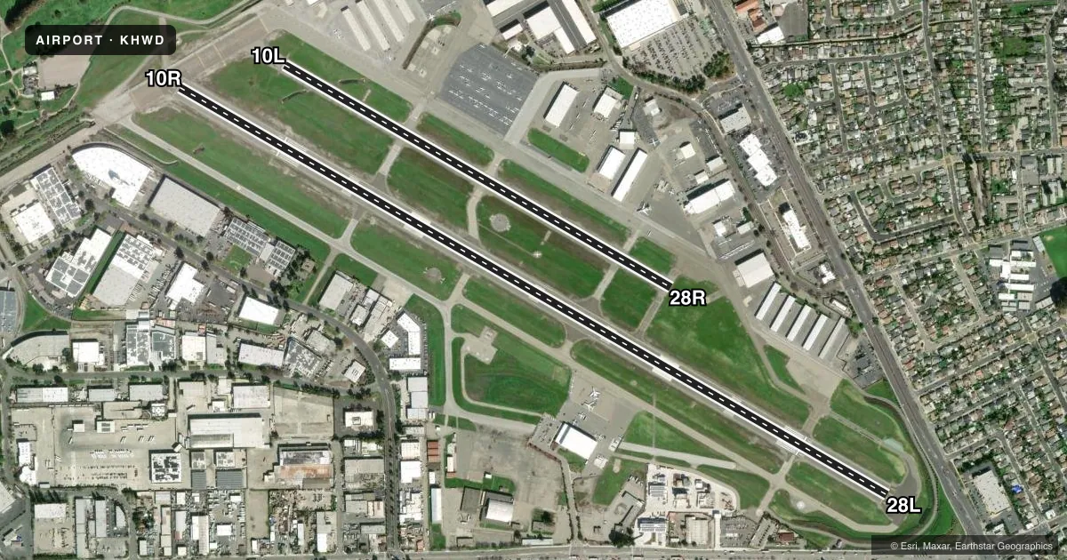
Runways & pattern
Full pagePattern entry · RWY 28L
LEFT TRAFFIC| Runway | Heading (°M) | Length | Surface | Traffic |
|---|---|---|---|---|
| 10R/28LFavored | 105° / 285° | 5,694 ft | ASPH | 10R R |
| 10L/28R | 105° / 285° | 3,108 ft | ASPH | 28R R |
Runway end performance
| End | TORA | TODA | ASDA | LDA | VGSI | Approach lights | Obstruction |
|---|---|---|---|---|---|---|---|
| 10R | — | — | — | — | VASI 4-box right(3°) | — | 40', tree, 1000' from thr, 250' R of cntrln, slope 20 |
| 28L | — | — | — | — | VASI 4-box left(4°) | — | — |
| 10L | — | — | — | — | PAPI 4-box left(3°) | — | 60', tree, 1085' from thr, 143' R of cntrln, slope 14 |
| 28R | — | — | — | — | PAPI 4-box left(3°) | — | — |
Declared distances in feet. TORA = takeoff run available, TODA = takeoff distance, ASDA = accelerate-stop, LDA = landing distance.
Airport sketch
Runways drawn to scale from FAA survey coordinates, rendered over satellite imagery. Not for navigation.
Approaches & charts
ILS · 1
Services on the field
Fuel grades, oxygen, maintenance, ramp storage and lighting — as declared to the FAA by the airport operator.
Fuel & services
- Fuel
- 100LLAUL94
- Oxygen (bottled)
- High pressure
- Oxygen (bulk)
- High pressure
- Airframe repair
- Major
- Power plant repair
- Major
- Other services
- CHTR,INSTR,RNTL
Ramp & ground
- Transient storage
- Tie-down
- Landing fee
- No fee published
- Customs
- Not available
- Lighting schedule
- SEE RMK
- Beacon schedule
- SS-SR
- Beacon
- White / Green (civil land)(WG)
- Wind indicator
- Lighted
- Segmented circle
- Yes
Fuel & FBOs
Cheapest 100LL and Jet A on the field and nearby. Always confirm with the FBO before taxi.
Airport notes
Surface conditions, obstructions, local procedures, lighting outages and other notes published with each FAA cycle.
General notes
- WHEN ATCT CLSD RWY 10L/28R CLSD.
- RY 10R HAS LANDING DISTANCE REMAINING SIGNS (LGTD) NORTH SIDE OF RY.
- RY 28L HAS LANDING DISTANCE REMAINING SIGNS (LGTD) SOUTH SIDE OF RY.
- FLOCKS OF BIRDS FEEDING ALONG THE SHORELINE, CREEK AREAS AND AT THE GOLF COURSE TO THE NORTH, ON OCCASION MAY FLY ACROSS VARIOUS PARTS OF THE ARPT.
- NOISE ABATEMENT PROCEDURES IN EFFECT CTC ARPT FOR NOISE RULES 510-293-8669.
- TRANSIENT HELICOPTER TFC USE HELIPADS WEST OF GREEN RAMP LCTD AT BASE OF ATCT.
- 155 FT ENERGY COMPLEX EXHAUST STACK 1 1/2 NM SW OF ARPT. DO NOT OVERFLY ENERGY COMPLEX FACILITY BELOW 1,000 FT MSL.
- TWY Z1 CLSD TO ACFT WITH WINGSPAN GTR THAN 94 FT.
- TWY A NOT VSB FM ATCT BTB TWY B & C
- FOR CD WHEN ATCT IS CLSD CTC NORCAL APCH AT 916-361-0516.
- TWY A1 CLSD TO ACFT WITH WINGSPAN GTR THAN 100 FT.
Lighting notes
- WHEN ATCT CLSD MIRL RWY 10R/28L PRESET LOW INTST; TO INCREASE INTST ACTVT - CTAF. WHEN ATCT CLSD VASI RWY 10R & 28L OPER SS-SR; PAPI RWY 10L & 28R, REIL RWY 10R & 28L UNAVBL.
Fuel notes
- UL94AVBL AT SELF-SERVE ISLAND.
Runway surface & condition
- 10R/28LSTRENGTH LIMITED BY STRENGTH OF CONNECTING TAXIWAYS.
Approach & departure obstructions
- 10RAPCH RATIO 45:1 FM DSPLCD THR.
Other notes
- INCLUDES 1 AMPHIBIAN.
- <TPA: 600'AGL EXCEPT RWY 10L-28R 800'AGL.
- OWNERCITY MANAGER
VFR map & nearby airports
VFR sectional. Tap any ICAO chip to open that airport.
Key facts · KHWD
Answer card- ICAO
- KHWD
- Name
- HAYWARD EXEC
- Location
- HAYWARD, CALIFORNIA
- Elevation
- 52.1 ft MSL
- Traffic pattern altitude
- 1,052.1 ft MSL (1,000 AGL)
- Control tower
- Towered · 0700-2100
- Total runways
- 2
- Longest runway
- 10R/28L · 5,694 ft
- Published ILS approaches
- 1
- Published frequencies
- 16
- Magnetic variation
- 15°
- Current flight rules
- MVFR
- Current wind
- 250° at 9 kt
- Favored runway now
- RWY 28L
Hayward Executive is in Hayward, California, on the east side of the Bay. Field elevation is 52.1 ft MSL. The airport has 2 asphalt runways. The longest is 10R/28L at 5,694 ft. The other runway is 10L/28R at 3,108 ft. The tower is open 0700-2100.
There is 1 ILS approach. It serves runway 28L. Pattern altitude is not published in the facts, so use the standard 1,000 ft AGL for light piston traffic unless the current FAA Chart Supplement says otherwise. That puts the pattern at about 1,052 ft MSL based on the field elevation.
Signature Aviation is on the field. It carries 100LL, Jet A and Jet A Prist. APP Jet Center is also on the field. It carries 100LL, Jet A, Jet A Prist and UL94. The airport sits in a busy Bay Area environment, so expect traffic flow discipline to matter. Published remarks also call out bird activity near shoreline and creek areas. There is a 155-foot exhaust stack southwest of the field. Do not overfly that energy complex below 1,000 ft MSL. When the tower is closed, runway 10L/28R is closed. That matters for late arrivals and early departures.