METAR & TAF KPAO
Current METAR
Observed 16:47Z
KPAO 271647Z 36005KT 10SM FEW010 19/13 A3006
- Wind
- 360° @ 5 kt
- Visibility
- 10 SM
- Temp / Dew
- 19°C / 13°C
- Altimeter
- 30.06 inHg
- Clouds
- FEW
- Density alt
- 315 ft
- Ceiling
- Unlimited
- Rules
- VFR
Airport info & contacts
Manager on record, flight service, ARTCC, attendance schedule and pattern altitude — published by the FAA and refreshed every 28 days.
Location
- From city
- 0 NM E
- VFR sectional
- SAN FRANCISCO
- ARTCC
- ZOA · OAKLAND
- NOTAM facility
- PAO (NOTAM-D)
Airport manager
- Name
- ANDREW SWANSON
- Phone
- (650) 329-2444
- Address
- 250 HAMILTON AVENUE, PALO ALTO CA 94301-2531
Flight service · Hours
- FSS OAK
- OAKLAND1-800-WX-BRIEF
- Attendance
- 0600-2000
Frequencies
Tap any row to copy the frequency to your clipboard.
Runways & pattern
Full pagePattern entry · RWY 31
RIGHT TRAFFICRunway end performance
| End | TORA | TODA | ASDA | LDA | VGSI | Approach lights | Obstruction |
|---|---|---|---|---|---|---|---|
| 13 | — | — | — | — | PAPI 2-box left(4°) | — | 8', berm, 300' from thr, 0' R of cntrln, slope 12 |
| 31 | — | — | — | — | PAPI 2-box left(4°) | — | 5', berm, 230' from thr, 0' R of cntrln, slope 6 |
Declared distances in feet. TORA = takeoff run available, TODA = takeoff distance, ASDA = accelerate-stop, LDA = landing distance.
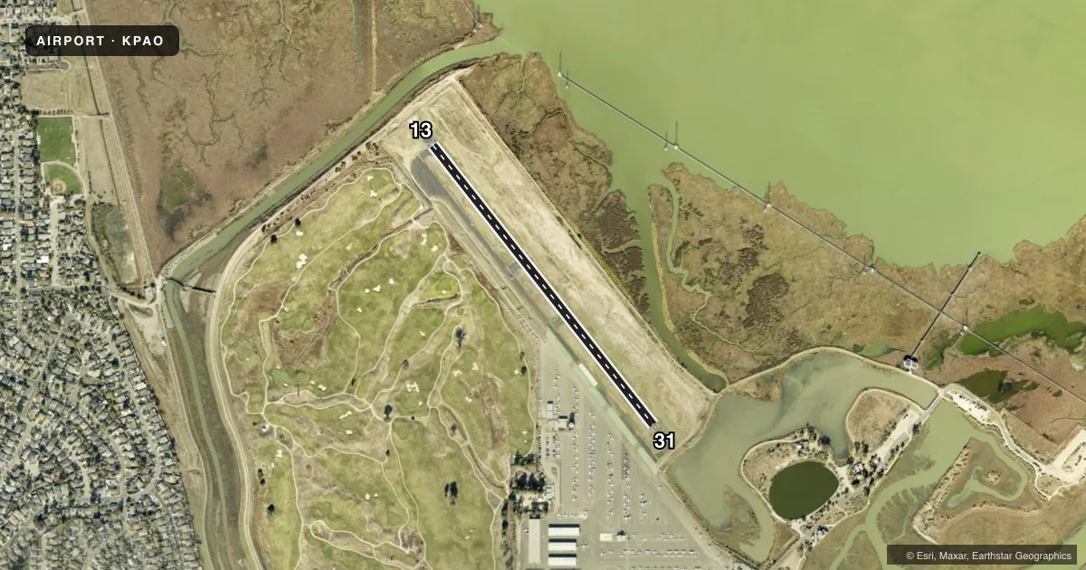
Airport sketch
Runways drawn to scale from FAA survey coordinates, rendered over satellite imagery. Not for navigation.
Approaches & charts
Services on the field
Fuel grades, oxygen, maintenance, ramp storage and lighting — as declared to the FAA by the airport operator.
Fuel & services
- Fuel
- 100LLA
- Oxygen (bottled)
- Low pressure
- Airframe repair
- Major
- Power plant repair
- Major
- Other services
- AMB,AVNCS,CHTR,GLD,INSTR,RNTL,SALES
Ramp & ground
- Transient storage
- Tie-down
- Landing fee
- No fee published
- Customs
- Not available
- Lighting schedule
- SEE RMK
- Beacon schedule
- SS-SR
- Beacon
- White / Green (civil land)(WG)
- Wind indicator
- Lighted
- Segmented circle
- Yes
Fuel & FBOs
Cheapest 100LL and Jet A on the field and nearby. Always confirm with the FBO before taxi.
Airport notes
Surface conditions, obstructions, local procedures, lighting outages and other notes published with each FAA cycle.
General notes
- +100 FT TRANSMISSION TWRS E OF ARPT.
- BIRDS ON AND INVOF AP.
- TPA 1000 FT W & 800 FT E.
- NOISE SENSITIVE AREA SE THRU NW OF ARPT. RCMD ACFT LDG AT PALO ALTO ARPT FLY AT OR ABOVE 1500 FT UNTIL XNG THE BAYSHORE FREEWAY, AND RCMD ACFT DEP RWY 31 TURN 10 DEG RIGHT AFTER TKOF TIL RCHG DUMBARTON AUTO BRIDGE.
- BE ALERT FOR PEDESTRAINS XNG A DIKE ROAD 8 FT HIGH AND 300 FT FROM RWY 13 END.
- CONS PEDESTRIAN/VEHICLE ACT ON ACFT TAXI LANES NOT DESIGNATED AS TWY MOV AREAS.
- ARPT SCTY PRODS IN EFCT.
- ON APCH TO RWY 31 BE ALERT TO POSS STG UPDRAFT FM WIND TUNNEL LCTD ON W SIDE OF MOFFETT FEDERAL AIRFIELD.
- ARPT RSTRD BY ARPT OPR TO ACFT WITH MAX CERTD WT OF 12500 LBS OR LESS.
- FOR CD WHEN ATCT IS CLSD CTC NORCAL APCH AT 916-361-3748.
Lighting notes
- ARPT LGTS OPERATE CONTINUOUSLY WHEN ATCT CLSD.
Fuel notes
- 100LLSELF-FUELING AVAILBLE 24/7.
Approach & departure obstructions
- 13RY 13 +8 FT DIKE 300 FT FROM RY END, OBSTN LGTD.
- 31RY 31 +5 FT DIKE 230 FT FROM RY END, OBSTN LGTD.
VFR map & nearby airports
VFR sectional. Tap any ICAO chip to open that airport.
Key facts · KPAO
Answer card- ICAO
- KPAO
- Name
- PALO ALTO
- Location
- PALO ALTO, CALIFORNIA
- Elevation
- 6.7 ft MSL
- Traffic pattern altitude
- 1,006.7 ft MSL (1,000 AGL)
- Control tower
- Towered · 0700-2100
- Total runways
- 1
- Longest runway
- 13/31 · 2,441 ft
- Published ILS approaches
- 0
- Published frequencies
- 13
- Magnetic variation
- 15°
- Current flight rules
- VFR
- Current wind
- 360° at 5 kt
- Favored runway now
- RWY 31
Palo Alto Airport sits in Palo Alto, California. Field elevation is 6.7 ft MSL. The airport has one runway. Runway 13/31 is 2,441 ft long with asphalt pavement. The tower is open daily from 0700 to 2100. No ILS approaches are published here.
Pattern altitude is not published as a single field-wide value. Use 1,000 ft AGL west of the field and 800 ft AGL east of the field. For a light piston, that is the normal starting point. Rossi Aircraft is on the field. It carries AVGAS 100LL, JET A and UL94. Self-fueling is available 24 hours a day, 7 days a week.
This is a busy Bay Area airport with noise-sensitive areas southeast through northwest of the field. The published arrival and departure guidance matters here. Arrivals should stay at or above 1,500 ft until crossing the Bayshore Freeway. Runway 31 departures should turn 10 degrees right after takeoff until reaching Dumbarton Auto Bridge. Watch the threshold area on runway 13. There is an 8 ft dike about 300 ft from the end. Birds are also reported in and around the airport. The field is restricted to aircraft with a maximum certified weight of 12,500 lb or less. When the tower is closed, airport lights operate continuously. For clearance delivery after tower hours, contact NorCal Approach.