METAR & TAF KHAF
Current METAR
Observed 15:15Z
KHAF 271515Z AUTO 32009G15KT 6SM BR OVC011 15/15 A3007 RMK AO2
- Wind
- 320° @ 9G15 kt
- Visibility
- 6 SM
- Temp / Dew
- 15°C / 15°C
- Altimeter
- 30.07 inHg
- Clouds
- OVC
- Density alt
- -104 ft
- Ceiling
- 1,100 ft AGL
- Rules
- MVFR
Airport info & contacts
Manager on record, flight service, ARTCC, attendance schedule and pattern altitude — published by the FAA and refreshed every 28 days.
Location
- From city
- 5 NM NW
- VFR sectional
- SAN FRANCISCO
- Pattern altitude
- 933 ft AGL · 999 ft MSL
- ARTCC
- ZOA · OAKLAND
- NOTAM facility
- OAK (NOTAM-D)
Airport manager
- Name
- MICHAEL BYRNE
- Phone
- 650-573-3700
- Address
- 620 AIRPORT DRIVE, SAN CARLOS CA 94070
Flight service · Hours
- FSS OAK
- OAKLAND1-800-WX-BRIEF
- Attendance
- 0800-1600
Frequencies
Tap any row to copy the frequency to your clipboard.
Runways & pattern
Full pagePattern entry · RWY 30
RIGHT TRAFFICRunway end performance
| End | TORA | TODA | ASDA | LDA | VGSI | Approach lights | Obstruction |
|---|---|---|---|---|---|---|---|
| 12 | — | — | — | — | PAPI 2-box left(3°) | — | 70', trees, 1390' from thr, 270' R of cntrln, slope 17 |
| 30 | — | — | — | — | PAPI 2-box left(3°) | — | 70', trees, 2478' from thr, 180' R of cntrln, slope 32 |
Declared distances in feet. TORA = takeoff run available, TODA = takeoff distance, ASDA = accelerate-stop, LDA = landing distance.
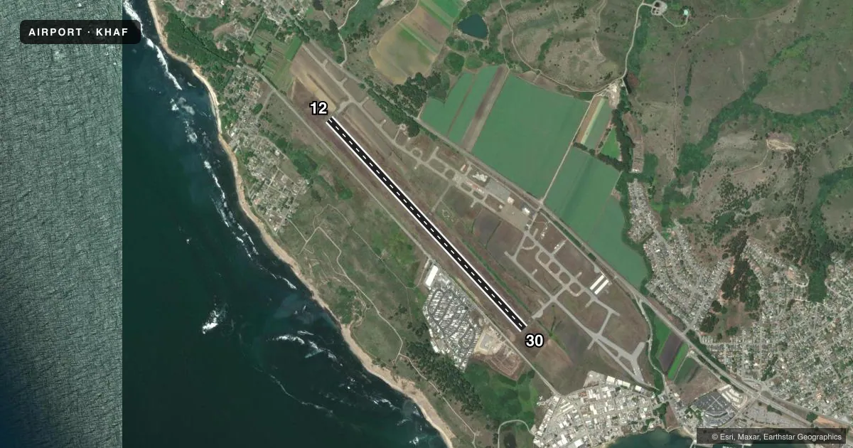
Airport sketch
Runways drawn to scale from FAA survey coordinates, rendered over satellite imagery. Not for navigation.
Approaches & charts
Services on the field
Fuel grades, oxygen, maintenance, ramp storage and lighting — as declared to the FAA by the airport operator.
Fuel & services
- Fuel
- 100LL
- Oxygen (bottled)
- Not available
- Oxygen (bulk)
- Not available
- Airframe repair
- Not available
- Power plant repair
- Not available
Ramp & ground
- Transient storage
- Tie-down
- Landing fee
- No fee published
- Customs
- Not available
- Lighting schedule
- SEE RMK
- Beacon schedule
- SS-SR
- Beacon
- White / Green (civil land)(WG)
- Wind indicator
- Lighted
- Segmented circle
- Yes
Fuel & FBOs
Cheapest 100LL and Jet A on the field and nearby. Always confirm with the FBO before taxi.
Airport notes
Surface conditions, obstructions, local procedures, lighting outages and other notes published with each FAA cycle.
General notes
- FLD CONDS-RWY, TWY & APRON GOOD.
- ARPT NOISE SENSITIVE AREAS NW THRU NE.
- TWYS, APRONS AND TIEDOWNS: 12,500 LBS MAXIMUM.
- FOR CD CTC NORCAL APCH AT 916-361-0519.
- UNEXPECTED TURBULENT CONDS MAY BE ENCTRD WHILE ON FNA TO RWY 12.
- AVOID FLYING DIRECTLY OVER THE PILLAR POINT AIR FORCE STATION.
Lighting notes
- ACTVT MIRL RY 12/30, REIL RY 30, PAPI RYS 12 AND 30 - 122.8.
Fuel notes
- 100LLFUEL AVBL 24 HRS SELF SERVICE.
Approach & departure obstructions
- 12APCH RATIO TO DSPLCD THR 50:1.
- 30APCH RATIO TO DSPLCD THR 50:1.
Other notes
- THIS AIRPORT HAS BEEN SURVEYED BY THE NATIONAL GEODETIC SURVEY.
- MANAGERMANAGER LOCATED AT SAN CARLOS AIRPORT.
- MANAGERMANAGERS OFFICE AIRPORT PHONE 650-573-3701.
- OWNERDIRECTOR OF PUBLIC WORKS: TORY A. NEWMAN
VFR map & nearby airports
VFR sectional. Tap any ICAO chip to open that airport.
Key facts · KHAF
Answer card- ICAO
- KHAF
- Name
- HALF MOON BAY
- Location
- HALF MOON BAY, CALIFORNIA
- Elevation
- 66.3 ft MSL
- Traffic pattern altitude
- 999.3 ft MSL (933 AGL)
- Control tower
- Non-towered (use CTAF)
- Total runways
- 1
- Longest runway
- 12/30 · 5,000 ft
- Published ILS approaches
- 0
- Published frequencies
- 4
- Magnetic variation
- 15°
- Current flight rules
- MVFR
- Current wind
- 320° at 9 kt
- Favored runway now
- RWY 30
Half Moon Bay Airport sits in Half Moon Bay, California. Field elevation is 66.3 ft MSL. The airport has one runway, 12/30, which is 5,000 ft long. There is no control tower. Pattern altitude is 933 ft AGL, which is 999.3 ft MSL.
No ILS approaches are published here. For clearance delivery, contact NorCal Approach at 916-361-0519. CTAF and UNICOM are both 122.8. NorCal Approach uses 135.1 and 307.2. The field is close to the coast, so expect marine influence and be ready for changing winds. Published remarks also call out unexpected turbulence on final to runway 12. Noise sensitive areas run from northwest through northeast. Plan your pattern work with that in mind.
Half Moon Bay Airport has one on-field FBO. Half Moon Bay Airport carries 100LL. Self-serve 100LL is available 24 hours. The manager's office phone number is 650-573-3701. Runway 12/30 has medium intensity lights. REILs are on runway 30. PAPI is available on both ends. The runway, taxiway and apron are reported in good condition. Taxiways, aprons and tiedowns have a 12,500 lb maximum weight limit. The airport has been surveyed by the National Geodetic Survey.