METAR & TAF KOAK
Current METAR
Observed 15:53Z
KOAK 271553Z 24010KT 10SM FEW006 BKN012 BKN015 16/13 A3006 RMK AO2 SLP180 T01610128
- Wind
- 240° @ 10 kt
- Visibility
- 10 SM
- Temp / Dew
- 16°C / 13°C
- Altimeter
- 30.06 inHg
- Clouds
- BKN
- Density alt
- -42 ft
- Ceiling
- 1,200 ft AGL
- Rules
- MVFR
Airport info & contacts
Manager on record, flight service, ARTCC, attendance schedule and pattern altitude — published by the FAA and refreshed every 28 days.
Location
- From city
- 4 NM S
- VFR sectional
- SAN FRANCISCO
- ARTCC
- ZOA · OAKLAND
- NOTAM facility
- OAK (NOTAM-D)
Airport manager
- Name
- MATT DAVIS
- Phone
- 510-563-6436
- Address
- OAKLAND INTL ARPT, 1 AIRPORT DRIVE, OAKLAND CA 94621
Flight service · Hours
- FSS OAK
- OAKLAND1-800-WX-BRIEF
- Attendance
- ALL
Frequencies
Tap any row to copy the frequency to your clipboard.
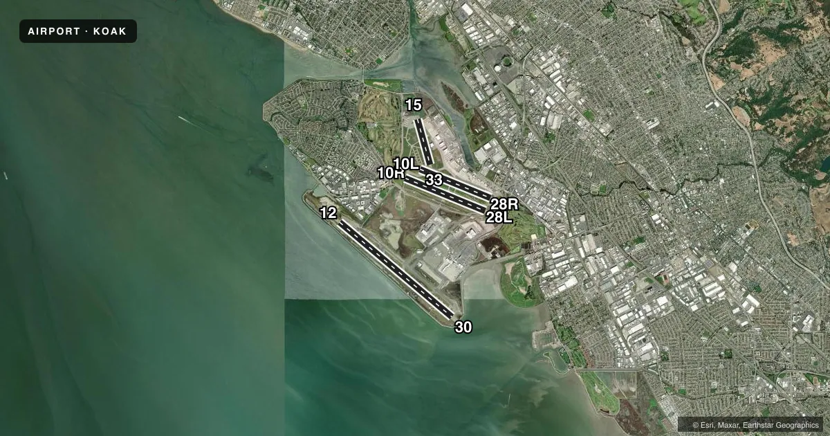
Runways & pattern
Full pagePattern entry · RWY 28L
LEFT TRAFFIC| Runway | Heading (°M) | Length | Surface | Traffic |
|---|---|---|---|---|
| 12/30 | 116° / 296° | 10,520 ft | ASPH | 12 R |
| 10R/28LFavored | 98° / 278° | 6,213 ft | ASPH | Standard L |
| 10L/28R | 98° / 278° | 5,457 ft | ASPH | 28R R |
| 15/33 | 150° / 330° | 3,376 ft | ASPH | 33 R |
Runway end performance
| End | TORA | TODA | ASDA | LDA | VGSI | Approach lights | Obstruction |
|---|---|---|---|---|---|---|---|
| 12 | 10,000' | 10,000' | 10,000' | 10,000' | PAPI 4-box right(2.75°) | MALSR | — |
| 30 | 10,000' | 10,000' | 10,000' | 10,000' | PAPI 4-box left(3°) | ALSF2 | — |
| 10R | 6,213' | 6,213' | 6,213' | 6,213' | PAPI 4-box left(3°) | — | — |
| 28L | 6,213' | 6,213' | 6,213' | 6,213' | PAPI 4-box right(3°) | — | — |
| 10L | 5,457' | 5,457' | 5,336' | 5,336' | PAPI 4-box right(3°) | — | — |
| 28R | 5,457' | 5,457' | 5,457' | 5,457' | PAPI 4-box left(3°) | MALSR | 11', bldg, 530' from thr, 480' R of cntrln, slope 30 |
Declared distances in feet. TORA = takeoff run available, TODA = takeoff distance, ASDA = accelerate-stop, LDA = landing distance.
Airport sketch
Runways drawn to scale from FAA survey coordinates, rendered over satellite imagery. Not for navigation.
Approaches & charts
ILS · 3
Services on the field
Fuel grades, oxygen, maintenance, ramp storage and lighting — as declared to the FAA by the airport operator.
Fuel & services
- Fuel
- 100LLA
- Oxygen (bottled)
- HIGH/LOW
- Oxygen (bulk)
- HIGH/LOW
- Airframe repair
- Major
- Power plant repair
- Major
- Other services
- AFRT,AVNCS,CARGO,CHTR,INSTR,RNTL,SALES
Ramp & ground
- Transient storage
- Tie-down
- Landing fee
- Yes
- Customs
- Not available
- Beacon schedule
- SS-SR
- Beacon
- White / Green (civil land)(WG)
- Wind indicator
- Lighted
- Segmented circle
- No
Fuel & FBOs
Cheapest 100LL and Jet A on the field and nearby. Always confirm with the FBO before taxi.
Airport notes
Surface conditions, obstructions, local procedures, lighting outages and other notes published with each FAA cycle.
General notes
- BIRDS ON & INVOF ARPT.
- 400 FT BY 220 FT BLAST PAD RWY 12 AND RWY 30.
- NOISE ABATEMENT PROCS N/A IN EMERGS OR WHENEVER RWY 12/30 IS UNAVBL DUE TO MAINT, SAFETY, WINDS OR WX.
- ACFT WITH EXPERIMENTAL OR LTD CERTIF HAVING OVER 1000 HORSEPOWER OR 4000 LBS ARE RSTRD TO RWY 12/30.
- 100 FT LGTD MICROWAVE ANT TWR LCTD 1320 FT WSW OF OAK VORTAC; S OF UPWIND END OF RWY 28L.
- RWYS 30, 28R AND RWY 28L DIST RMNG SIGNS L SIDE.
- FOR NOISE ABATEMENT INFO CTC NOISE ABATEMENT OFC AT 510-563-6463 OR VISIT ARPT WEBSITE.
- 24 HR NOISE ABATEMENT PROC: TBJT AND TURBOFAN PWRD ACFT, TURBOROPS OVER 17000 LBS, FOUR-ENG RECIPROCATING PWRD ACFT, AND SURPLUS MIL ACFT OVER 12500 LBS SHOULD USE RWY 12/30.
- TWY A, E, G, H BTN RWY 28R AND TWY C MAX ACFT WT 150,000 LBS.
- TWY G & H BTN RWY 28L & 28R: MAX ACFT WT 12,500 LBS.
- TWY P MAX ACFT WT 116,000 LBS SINGLE; 190,000 LBS DUAL; 305,000 LBS DUAL TANDEM; 735,000 LBS DOUBLE DUAL TANDEM.
- TWY C BTN RWY 28R & TWY G AND TWYS B, J, AND D MAX ACFT WT 861,000 LBS.
- TWY C BTN TWY G & J MAX ACFT WEIGHT 90,000 LBS SINGLE; 144,000 LBS DUAL; 257,000 LBS TANDEM.
- TWY C BTN TWY J & F MAX ACFT WEIGHT 76,000 LBS SINGLE; 115,000 LBS DUAL; 257,000 LBS TANDEM (DUAL TANDEM NA).
- TWY K BTN TWY D & INT TWYS F, L, K MAX ACFT WEIGHT 56,000 LBS SINGLE; 70,000 LBS DUAL; 130,000 LBS TANDEM.
- TWY K BTN TWY J AND INT TWYS F, L, K MAX ACFT WT 33000 LBS SINGLE; 45000 LBS DUAL; TANDEM NA.
- UNDERLIES CLASS B ASP, BE AWARE OF SPEEDS ON ARR AND DEP.
Runway surface & condition
- 10L/28RPCR VALUE: 1266/F/B/X/T
- 10R/28LPCR VALUE: 934/F/B/X/T
- 12/30PCR VALUE: 1295/F/B/X/T
- 15/33RWY 15/33 NOT AVBL FOR PART 121/PART 380 OPS WITH SKED PAX CARRYING OPS MORE THAN 9 PAX SEATS AND NON-SKED PAX CARRYING OPS MORE THAN 30 PAX SEATS.
Arresting gear
- 28L_EMASENGINEERED MATERIALS ARRESTING SYSTEM (EMAS) 162 FT IN LENGTH BY 154 FT IN WIDTH LCTD AT THE DER 28L.
Other notes
- LDG FEE IN EFCT 24 HRS/DAY, CTC AIRFIELD OPS (510) 563-3361.
- TFC PAT ALT RWY 28L 606' MSL; RWY 28R 1006' MSL.
- MANAGEROPERATIONS - DARRON EVANS, OPNS SUPERINTENDENT (510)563-6432, CELL: (510) 715-6286 24HR OPERATIONS (510) 563-3361.
VFR map & nearby airports
VFR sectional. Tap any ICAO chip to open that airport.
Key facts · KOAK
Answer card- ICAO
- KOAK
- Name
- OAKLAND SAN FRANCISCO BAY
- Location
- OAKLAND, CALIFORNIA
- Elevation
- 9 ft MSL
- Traffic pattern altitude
- 1,009 ft MSL (1,000 AGL)
- Control tower
- Towered · 24
- Total runways
- 4
- Longest runway
- 12/30 · 10,520 ft
- Published ILS approaches
- 3
- Published frequencies
- 36
- Magnetic variation
- 14°
- Current flight rules
- MVFR
- Current wind
- 240° at 10 kt
- Favored runway now
- RWY 28L
Oakland San Francisco Bay Airport is in Oakland, California. Field elevation is 9 ft MSL. The airport has four asphalt runways. The longest is 12/30 at 10,520 ft. The tower is open 24 hours. KOAK has 3 ILS approach ends. Those are runway 12, 28R and 30.
Pattern altitude is not published in the facts. Use 1,000 ft AGL for light piston traffic unless current local guidance says otherwise. The airport sits under Class B airspace. Watch your speeds on arrival and departure. That matters here.
On the field, Signature Aviation carries 100LL and Jet A. KaiserAir carries 100LL, Jet A and Jet A Prist. Birds are reported on and near the airport. Taxiway and pavement weight limits are published in the Chart Supplement, so check those before bringing in anything heavy. Noise abatement procedures are not applicable in emergencies or when runway 12/30 is unavailable for maintenance, safety, winds, or weather. If you need current operational details, confirm them with the airport operator or the FBO directly by phone before you go.