METAR & TAF KLVK
Current METAR
Observed 14:53Z
KLVK 271453Z VRB03KT 10SM CLR 15/12 A3003 RMK AO2 SLP167 T01500117 51013
- Wind
- VAR @ 3 kt
- Visibility
- 10 SM
- Temp / Dew
- 15°C / 12°C
- Altimeter
- 30.03 inHg
- Clouds
- CLR
- Density alt
- 359 ft
- Ceiling
- Unlimited
- Rules
- VFR
Airport info & contacts
Manager on record, flight service, ARTCC, attendance schedule and pattern altitude — published by the FAA and refreshed every 28 days.
Location
- From city
- 3 NM W
- VFR sectional
- SAN FRANCISCO
- ARTCC
- ZOA · OAKLAND
- NOTAM facility
- LVK (NOTAM-D)
Airport manager
- Name
- BENEDICT STUTH
- Phone
- 925-960-8230
- Address
- 680 TERMINAL CIRCLE, LIVERMORE CA 94551
Flight service · Hours
- FSS OAK
- OAKLAND1-800-WX-BRIEF
- Attendance
- MON-FRI · 0730-1700
- SAT-SUN · 0700-1100
Frequencies
Tap any row to copy the frequency to your clipboard.
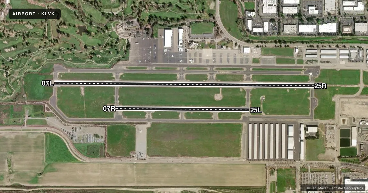
Runways & pattern
Full pagePattern entry · RWY 07L
LEFT TRAFFIC| Runway | Heading (°M) | Length | Surface | Traffic |
|---|---|---|---|---|
| 07L/25RFavored | 74° / 254° | 5,253 ft | ASPH | 25R R |
| 07R/25L | 74° / 254° | 2,699 ft | ASPH | 07R R |
Runway end performance
| End | TORA | TODA | ASDA | LDA | VGSI | Approach lights | Obstruction |
|---|---|---|---|---|---|---|---|
| 07L | — | — | — | — | PAPI 4-box right(4°) | — | 75', tree, 2016' from thr, 350' R of cntrln, slope 24 |
| 25R | — | — | — | — | PAPI 4-box left(3°) | MALSR | 24', bldg, 638' from thr, 560' R of cntrln, slope 18 |
Declared distances in feet. TORA = takeoff run available, TODA = takeoff distance, ASDA = accelerate-stop, LDA = landing distance.
Airport sketch
Runways drawn to scale from FAA survey coordinates, rendered over satellite imagery. Not for navigation.
Approaches & charts
ILS · 1
Services on the field
Fuel grades, oxygen, maintenance, ramp storage and lighting — as declared to the FAA by the airport operator.
Fuel & services
- Fuel
- 100LLA
- Oxygen (bottled)
- High pressure
- Oxygen (bulk)
- High pressure
- Airframe repair
- Major
- Power plant repair
- Major
- Other services
- AVNCS,CHTR,INSTR,RNTL,SALES
Ramp & ground
- Transient storage
- Tie-down
- Landing fee
- No fee published
- Customs
- Not available
- Lighting schedule
- SEE RMK
- Beacon schedule
- SS-SR
- Beacon
- White / Green (civil land)(WG)
- Wind indicator
- Lighted
- Segmented circle
- Yes
Fuel & FBOs
Cheapest 100LL and Jet A on the field and nearby. Always confirm with the FBO before taxi.
Airport notes
Surface conditions, obstructions, local procedures, lighting outages and other notes published with each FAA cycle.
General notes
- BE ALERT TO CONSIDERABLE BIRD ACTIVITY ON & IN VICINITY OF ARPT.
- DO NOT MISTAKE PARALLEL TAXIWAY N OF RWY 25R/7L AS RWY. NOISE SENSITIVE AREAS 3/4 MILE EAST & 2 MILES W OF ARPT.
- EFFECTIVE RY GRADIENT RY 07L 0.52% UP; RY 07R 0.59% UP.
- FOR CD WHEN ATCT IS CLSD CTC NORCAL APCH AT 916-361-0516.
- PLS OBS "VOLUNTARY RESTRAINT FROM NIGHT FLYING 2200L-0600L POLICY."
Lighting notes
- ATC CNTL. WHEN ATCT CLSD, ACTVT MALSR RWY 25R; TWY LGTS - 118.1. HIRL RWY 07L/25R OPER LOW INTST; TO INCREASE INTST ACTVT 118.1. MIRL RWY 07R/25L OPER LOW INTST; NOT AVBL WHEN ATCT CLSD. PAPI RWY 07L AND 25R OPR CONSLY.
Runway surface & condition
- 07L/25RRWY EDGE LGT ON LOW AND MED INTST LEVEL ON DOWNWIND LEG OF TFC PAT DFCLT TO SEE.
Approach & departure obstructions
- 07L+6 FT FENCE 180 FT FM RY END 400 FT LEFT OF EXTDD CNTRLN.
VFR map & nearby airports
VFR sectional. Tap any ICAO chip to open that airport.
Key facts · KLVK
Answer card- ICAO
- KLVK
- Name
- LIVERMORE MUNI
- Location
- LIVERMORE, CALIFORNIA
- Elevation
- 399.9 ft MSL
- Traffic pattern altitude
- 1,399.9 ft MSL (1,000 AGL)
- Control tower
- Towered · 0700-2100
- Total runways
- 2
- Longest runway
- 07L/25R · 5,253 ft
- Published ILS approaches
- 1
- Published frequencies
- 12
- Magnetic variation
- 16°
- Current flight rules
- VFR
- Current wind
- 000° at 3 kt
- Favored runway now
- RWY 07L
Livermore Muni sits in Livermore, California at 399.9 ft MSL. It has two asphalt runways. The longest is 07L/25R at 5,253 ft. The tower is open daily from 0700 to 2100 local. One ILS approach is published for runway 25R. Pattern altitude is not published, so use the standard 1,000 ft AGL for light piston traffic unless the current Chart Supplement says otherwise.
Five Rivers Aviation is on the field. It carries AVGAS 100LL, JET A, JET A Prist and UL94. The airport sits in a busy Bay Area flow, so expect NORCAL coordination. Pay attention to the published noise sensitive areas east and west of the field. The Chart Supplement also warns not to confuse the parallel taxiway north of 25R/7L with a runway. That matters here because the layout can look busy from the air.
Lighting details matter at night. The runway edge lights on 07L/25R can be hard to see on the downwind leg. When the tower is closed, use the published lighting procedures and call NORCAL Approach for clearance delivery. There is also a voluntary restraint from night flying from 2200 local to 0600 local. Bird activity is noted on and near the airport, so keep your scan active on arrival and departure.