METAR & TAF 0Q3
0Q3 does not publish a METAR.
Showing the nearest reporting station: KDVO (GNOSS FLD) · 7.0 NM away. Conditions at 0Q3 may differ.
METAR · KDVO
Observed 10:15Z
KDVO 271015Z AUTO 00000KT 10SM CLR 12/11 A2998 RMK AO2
- Wind
- 000° @ 0 kt
- Visibility
- 10 SM
- Temp / Dew
- 12°C / 11°C
- Altimeter
- 29.98 inHg
- Clouds
- CLR
- Density alt
- -415 ft
- Ceiling
- Unlimited
- Rules
- VFR
Airport info & contacts
Manager on record, flight service, ARTCC, attendance schedule and pattern altitude — published by the FAA and refreshed every 28 days.
Location
- From city
- 4 NM S
- VFR sectional
- SAN FRANCISCO
- Pattern altitude
- 800 ft AGL · 816 ft MSL
- ARTCC
- ZOA · OAKLAND
- NOTAM facility
- OAK (NOTAM-D)
Airport manager
- Name
- CHRISTOPHER D. PREVOST
- Phone
- 707-938-2444
- Address
- 23982 ARNOLD DR, SONOMA CA 95476
Flight service · Hours
- FSS OAK
- OAKLAND1-800-WX-BRIEF
- Attendance
- 0700-1800
Frequencies
Tap any row to copy the frequency to your clipboard.
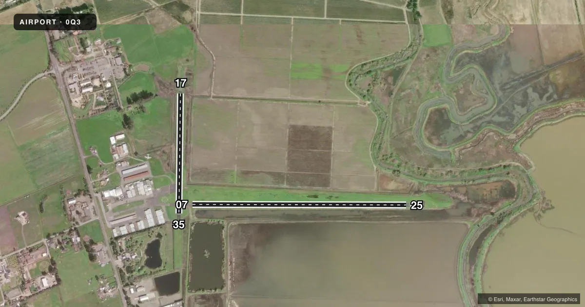
Runways & pattern
Full pagePattern entry · RWY 07
RIGHT TRAFFIC| Runway | Heading (°M) | Length | Surface | Traffic |
|---|---|---|---|---|
| 07/25 | 74° / 254° | 2,700 ft | ASPH | 07 R |
| 17/35 | 165° / 345° | 1,513 ft | ASPH | 35 R |
Runway end performance
| End | TORA | TODA | ASDA | LDA | VGSI | Approach lights | Obstruction |
|---|---|---|---|---|---|---|---|
| 07 | — | — | — | — | — | — | 90', tree, 1415' from thr, 60' R of cntrln, slope 13 |
Declared distances in feet. TORA = takeoff run available, TODA = takeoff distance, ASDA = accelerate-stop, LDA = landing distance.
Airport sketch
Runways drawn to scale from FAA survey coordinates, rendered over satellite imagery. Not for navigation.
Approaches & charts
Services on the field
Fuel grades, oxygen, maintenance, ramp storage and lighting — as declared to the FAA by the airport operator.
Fuel & services
- Fuel
- 100LL
- Oxygen (bottled)
- Not available
- Oxygen (bulk)
- Not available
- Airframe repair
- Major
- Power plant repair
- Major
Ramp & ground
- Transient storage
- Tie-down
- Landing fee
- No fee published
- Customs
- Not available
- Wind indicator
- Yes
- Segmented circle
- Yes
Fuel & FBOs
Cheapest 100LL and Jet A on the field and nearby. Always confirm with the FBO before taxi.
Airport notes
Surface conditions, obstructions, local procedures, lighting outages and other notes published with each FAA cycle.
General notes
- RY 07/25 ELEVATED 3'-5' ABV NORTH TERRAIN WITH 6:1 SIDE SLOPES.
- RY 07/25 NO TGL OR TRNG OPS; RY 25 RIGHT 20 DEG TURN AFTER TKOF; RY 25 TURN CROSSWIND AFTER 600 FT.
- DAY USE ONLY
- FOR CD CTC OAKLAND ARTCC AT 510-745-3380.
Runway surface & condition
- 17/35RESTRICTED PRIOR PERMISSION REQUIRED.
Other notes
- PREDATES 1958 FA ACT.
VFR map & nearby airports
VFR sectional. Tap any ICAO chip to open that airport.
Key facts · 0Q3
Answer card- ICAO
- 0Q3
- Name
- SONOMA VALLEY
- Location
- SCHELLVILLE/SONOMA, CALIFORNIA
- Elevation
- 16 ft MSL
- Traffic pattern altitude
- 816 ft MSL (800 AGL)
- Control tower
- Non-towered (use CTAF)
- Total runways
- 2
- Longest runway
- 07/25 · 2,700 ft
- Published ILS approaches
- 0
- Published frequencies
- 1
- Magnetic variation
- 16°
- Current flight rules
- VFR
- Current wind
- 000° at 0 kt
- Favored runway now
- –
Sonoma Valley Airport (0Q3) sits in Schellville, Sonoma, California. The field elevation is 16 ft MSL. It has two asphalt runways. The longest is runway 07/25 at 2,700 ft. This is an uncontrolled airport with no tower. CTAF is 122.9. Pattern altitude is 800 ft AGL, which is 816 ft MSL.
No ILS approaches are published here. Vintage Aircraft is on the field. It carries 100LL. Call (707) 938-2444 before you go if you need current ramp or service details. The published remarks matter here. Runway 07/25 sits a few feet above the north terrain with side slopes. Runway 17/35 is restricted. Prior permission is required. The field is day use only. Runway 07/25 also has no touch-and-go or training operations. Runway 25 calls for an early right turn after takeoff. Then a crosswind turn after 600 feet.
This is a low-elevation field in Sonoma Valley, so density altitude is usually not the same issue you get at mountain airports. The bigger pilot items are runway use, local procedures and getting the latest clearance details from Oakland ARTCC if needed. Check the current FAA Chart Supplement before departure for any updates.