METAR & TAF KSTS
Current METAR
Observed 11:53Z
KSTS 271153Z AUTO 00000KT 10SM CLR 11/09 A2999 RMK AO2 SLP147 T01060094 10144 20100 55001 $
- Wind
- 000° @ 0 kt
- Visibility
- 10 SM
- Temp / Dew
- 11°C / 9°C
- Altimeter
- 29.99 inHg
- Clouds
- CLR
- Density alt
- -407 ft
- Ceiling
- Unlimited
- Rules
- VFR
Airport info & contacts
Manager on record, flight service, ARTCC, attendance schedule and pattern altitude — published by the FAA and refreshed every 28 days.
Location
- From city
- 6 NM NW
- VFR sectional
- SAN FRANCISCO
- ARTCC
- ZOA · OAKLAND
- NOTAM facility
- STS (NOTAM-D)
Airport manager
- Name
- JON G. STOUT
- Phone
- 707-565-7243
- Address
- 2290 AIRPORT BLVD, SANTA ROSA CA 95403
Flight service · Hours
- FSS OAK
- OAKLAND1-800-WX-BRIEF
- Attendance
- 0600-2200
Frequencies
Tap any row to copy the frequency to your clipboard.
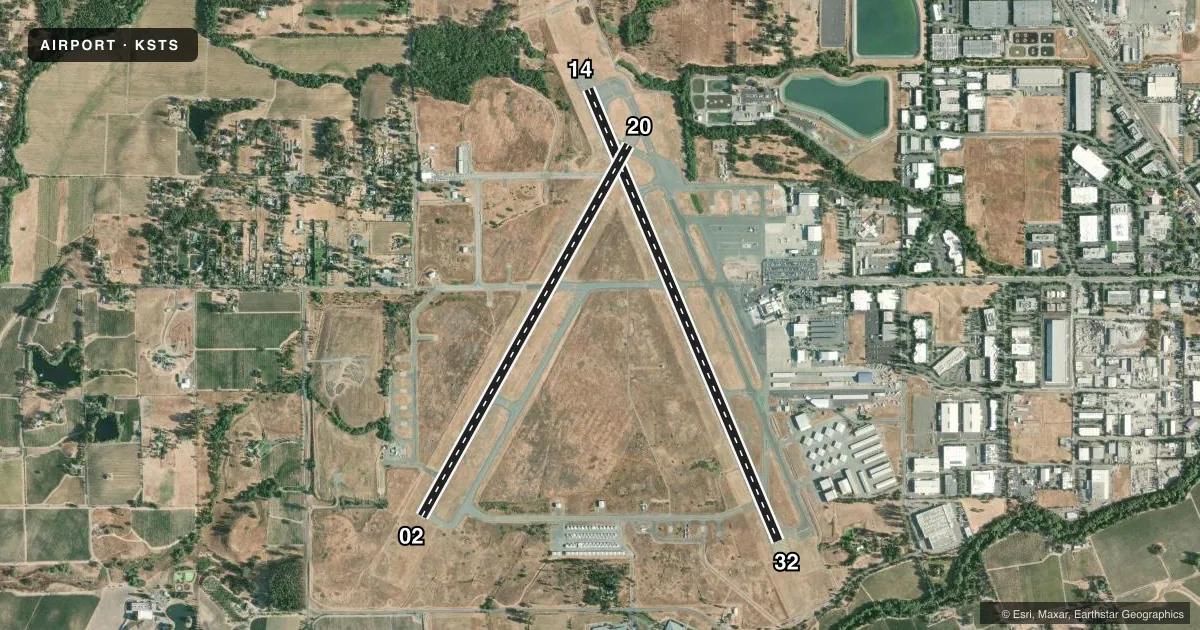
Runways & pattern
Full pagePattern entry · RWY 14
RIGHT TRAFFIC| Runway | Heading (°M) | Length | Surface | Traffic |
|---|---|---|---|---|
| 14/32 | 141° / 321° | 6,000 ft | ASPH | 14 R |
| 02/20 | 13° / 193° | 5,202 ft | ASPH | Standard L |
Runway end performance
| End | TORA | TODA | ASDA | LDA | VGSI | Approach lights | Obstruction |
|---|---|---|---|---|---|---|---|
| 14 | 6,000' | 6,000' | 5,880' | 5,880' | PAPI 4-box right(3°) | — | 17', trees, 800' from thr, 250' R of cntrln, slope 35 |
| 32 | 6,000' | 6,000' | 6,000' | 6,000' | — | MALSR | 135', trees, 6400' from thr, slope 45 |
| 02 | 5,202' | 5,202' | 4,802' | 4,802' | PAPI 2-box left(3°) | — | 131', trees, 2900' from thr, 0' R of cntrln, slope 20 |
| 20 | 5,202' | 5,202' | 5,202' | 5,202' | PAPI 4-box left(3.5°) | — | 33', trees, 1200' from thr, 200' R of cntrln, slope 30 |
Declared distances in feet. TORA = takeoff run available, TODA = takeoff distance, ASDA = accelerate-stop, LDA = landing distance.
Airport sketch
Runways drawn to scale from FAA survey coordinates, rendered over satellite imagery. Not for navigation.
Approaches & charts
ILS · 1
Services on the field
Fuel grades, oxygen, maintenance, ramp storage and lighting — as declared to the FAA by the airport operator.
Fuel & services
- Fuel
- 100LLA1
- Oxygen (bottled)
- Low pressure
- Oxygen (bulk)
- Low pressure
- Airframe repair
- Major
- Power plant repair
- Major
- Other services
- AVNCS,CARGO,CHTR,INSTR,RNTL,SALES
Ramp & ground
- Transient storage
- Tie-down
- Landing fee
- Yes
- Customs
- Not available
- Lighting schedule
- SEE RMK
- Beacon schedule
- SS-SR
- Beacon
- White / Green (civil land)(WG)
- Wind indicator
- Lighted
- Segmented circle
- Yes
Fuel & FBOs
Cheapest 100LL and Jet A on the field and nearby. Always confirm with the FBO before taxi.
Airport notes
Surface conditions, obstructions, local procedures, lighting outages and other notes published with each FAA cycle.
General notes
- FOR NOISE ABATEMENT PROCS PLEASE VISIT THE ARPT WEBSITE AT FLYSTS.COM
- TWY Z BTN RWY 14/32 & TWY A LMTD TO S-20, D-40.
- BE ALERT FOR NUMEROUS FLOCKS OF BIRDS ON AND INVOF AIRPORT, INCLUDING SEASONALLY MIGRATORY GEESE.
- DEER ON AND INVOF ARPT.
- WHEN ATCT CLSD, FOR CD CTC OAKLAND ARTCC AT 510-745-3380.
Lighting notes
- WHEN ATCT CLSD ACTVT REIL RWY 14; MALSR RWY 32; PAPI RWY 02, 20, & 14; HIRL RWY 14/32; MIRL RWY 02/20; TWY LGTS - CTAF.
Fuel notes
- 100LL100LL AVBL 24 HRS WITH CREDIT CARD.
- A1JET A1 AVBL DURG ATTENDANCE HRS.
Runway surface & condition
- 02/20PCR VALUE: 309/F/C/X/T
- 14/32PCR VALUE: 454/F/C/X/T
Approach & departure obstructions
- 02CTC ATCT FOR AVBLTY.
- 02PAPI UNUSBL BYD 5 DEG LEFT OF CNTRLN
Other notes
- EXISTED PRIOR TO 5/15/59.
- TPA FOR SMALL ACFT 1,000 FT AGL AND TPA FOR LARGE ACFT 1,500 FT AGL.
- MANAGERSAMONAE CARTER, ASST ARPT MGR, PHONE 707- 565-7245.
VFR map & nearby airports
VFR sectional. Tap any ICAO chip to open that airport.
Key facts · KSTS
Answer card- ICAO
- KSTS
- Name
- CHARLES M SCHULZ/SONOMA COUNTY
- Location
- SANTA ROSA, CALIFORNIA
- Elevation
- 128.7 ft MSL
- Traffic pattern altitude
- 1,128.7 ft MSL (1,000 AGL)
- Control tower
- Towered · 0700-2000
- Total runways
- 2
- Longest runway
- 14/32 · 6,000 ft
- Published ILS approaches
- 1
- Published frequencies
- 7
- Magnetic variation
- 16°
- Current flight rules
- VFR
- Current wind
- 000° at 0 kt
- Favored runway now
- –
Charles M Schulz/Sonoma County Airport is in Santa Rosa, California. Field elevation is 128.7 ft MSL. The airport has two asphalt runways. The longest is runway 14/32 at 6,000 ft. Runway 02/20 is 5,202 ft.
The field is towered from 0700 to 2000. One ILS approach is published. It serves runway 32. Pattern altitude is not published in the facts. Use the standard 1,000 ft AGL for light piston traffic unless the current FAA Chart Supplement says otherwise.
KaiserAir and Sonoma Jet Center are on the field. KaiserAir carries 100LL, Jet A and Jet A Prist. Sonoma Jet Center carries 100LL, Jet A and Jet A Prist. 100LL is available 24 hours with credit card. Jet A1 is available during attendance hours. Deer are reported on and near the airport. That matters on taxi, takeoff and landing roll.
The airport sits in the Santa Rosa area with published noise abatement guidance. Check the current FAA Chart Supplement and the airport website before arrival. When the tower is closed, clearance delivery goes through Oakland ARTCC. Taxiway Z between runway 14/32 and taxiway A has weight limits for single-engine and dual-engine aircraft. Runway 02 has a note about landing and hold short operations. Runway 02 PAPI is unusable more than 5 degrees left of centerline. If you are planning a night arrival, review the lighting notes before you go.