METAR & TAF KHES
KHES does not publish a METAR.
Showing the nearest reporting station: KSTS (CHARLES M SCHULZ/SONOMA COUNTY) · 9.5 NM away. Conditions at KHES may differ.
METAR · KSTS
Observed 05:53Z
KSTS 270553Z AUTO 00000KT 10SM CLR 14/12 A3001 RMK AO2 SLP156 T01440117 10272 20144 51013 $
- Wind
- 000° @ 0 kt
- Visibility
- 10 SM
- Temp / Dew
- 14°C / 12°C
- Altimeter
- 30.01 inHg
- Clouds
- CLR
- Density alt
- 116 ft
- Ceiling
- Unlimited
- Rules
- VFR
Airport info & contacts
Manager on record, flight service, ARTCC, attendance schedule and pattern altitude — published by the FAA and refreshed every 28 days.
Location
- From city
- 3 NM NW
- VFR sectional
- SAN FRANCISCO
- ARTCC
- ZOA · OAKLAND
- NOTAM facility
- OAK (NOTAM-D)
Airport manager
- Name
- BARRY HOLLOWAY
- Phone
- 707-433-8540
- Address
- 1500 LYTTON SPRINGS RD, HEALDSBURG CA 95448
Flight service · Hours
- FSS OAK
- OAKLAND1-800-WX-BRIEF
- Attendance
- 0800-1700
Frequencies
Tap any row to copy the frequency to your clipboard.
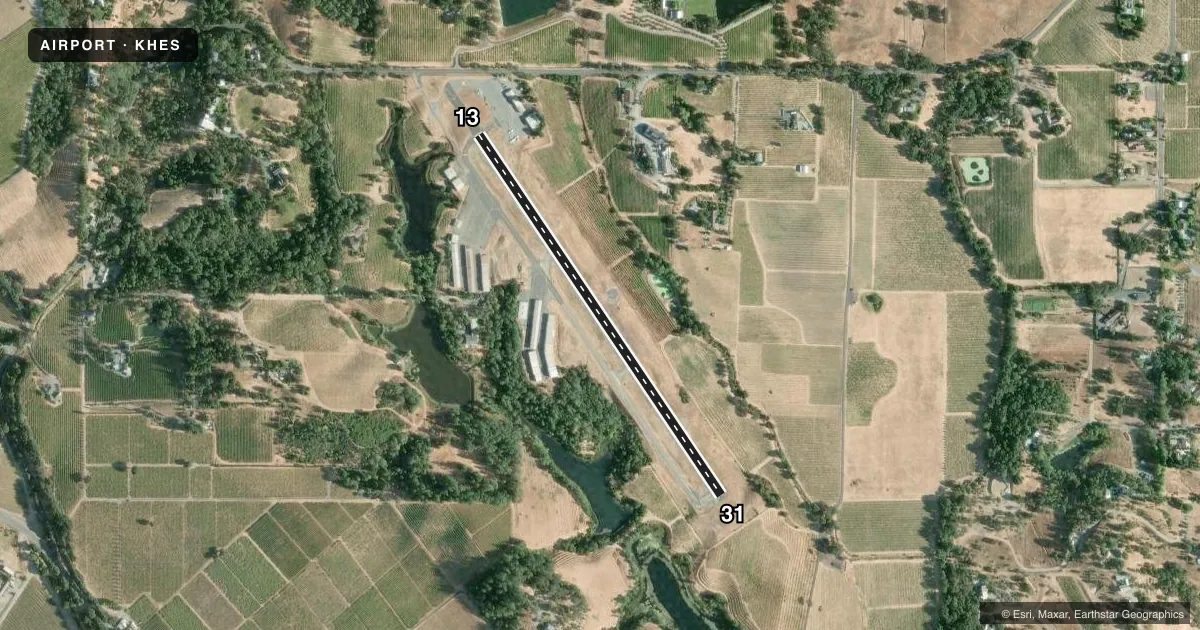
Runways & pattern
Full pagePattern entry · RWY 13
RIGHT TRAFFICRunway end performance
| End | TORA | TODA | ASDA | LDA | VGSI | Approach lights | Obstruction |
|---|---|---|---|---|---|---|---|
| 13 | — | — | — | — | PAPI 2-box left(4°) | — | 15', road, 340' from thr, 140' R of cntrln, slope 9 |
| 31 | — | — | — | — | PAPI 2-box left(4°) | — | 53', hill, 2040' from thr, 400' R of cntrln, slope 33 |
Declared distances in feet. TORA = takeoff run available, TODA = takeoff distance, ASDA = accelerate-stop, LDA = landing distance.
Airport sketch
Runways drawn to scale from FAA survey coordinates, rendered over satellite imagery. Not for navigation.
Approaches & charts
Services on the field
Fuel grades, oxygen, maintenance, ramp storage and lighting — as declared to the FAA by the airport operator.
Fuel & services
- Fuel
- 100LL
- Oxygen (bottled)
- Not available
- Oxygen (bulk)
- Not available
- Airframe repair
- Major
- Power plant repair
- Major
- Other services
- CHTR,INSTR,RNTL
Ramp & ground
- Transient storage
- Tie-down
- Landing fee
- No fee published
- Customs
- Not available
- Lighting schedule
- SEE RMK
- Wind indicator
- Lighted
- Segmented circle
- Yes
Fuel & FBOs
Cheapest 100LL and Jet A on the field and nearby. Always confirm with the FBO before taxi.
Airport notes
Surface conditions, obstructions, local procedures, lighting outages and other notes published with each FAA cycle.
General notes
- NO TOUCH & GO. PRACTICE LNDGS LTD TO 3 OPS/DAY.
- RWY 31 DOWNDRAFTS APCH END.
- FOR CD CTC OAKLAND ARTCC AT 510-745-3380.
- LOCAL ARPT ADZY (NOT FAA APRVD) WX IS AVBL ON CTAF. THREE CLICKS WI 3 SECS GIVES WX INFO.
Lighting notes
- ACTVT MIRL RY 13/31 - CTAF.
Runway surface & condition
- 13/31ESTIMATED BY OWNER.
Other notes
- ESTABD PRIOR TO 15 MAY 1959.
- AUTOMATED UNICOM.
VFR map & nearby airports
VFR sectional. Tap any ICAO chip to open that airport.
Key facts · KHES
Answer card- ICAO
- KHES
- Name
- HEALDSBURG MUNI
- Location
- HEALDSBURG, CALIFORNIA
- Elevation
- 280 ft MSL
- Traffic pattern altitude
- 1,280 ft MSL (1,000 AGL)
- Control tower
- Non-towered (use CTAF)
- Total runways
- 1
- Longest runway
- 13/31 · 2,652 ft
- Published ILS approaches
- 0
- Published frequencies
- 2
- Magnetic variation
- 16°
- Current flight rules
- VFR
- Current wind
- 000° at 0 kt
- Favored runway now
- –
Healdsburg Muni sits in Healdsburg, California. Field elevation is 280 ft MSL. The airport has one runway, 13/31, which is 2,652 ft long and asphalt. There is no control tower. CTAF and UNICOM are both 122.8. No ILS approaches are published here.
Pattern altitude is not published. Use the standard 1,000 ft AGL for light piston traffic unless the current Chart Supplement or local procedures say otherwise. The field has one on-field FBO, Healdsburg Municipal Airport. It carries AVGAS 100LL. Call (707) 433-8540 for current service details. Published remarks also note CTAF weather information. Three clicks within three seconds gives the weather. Medium intensity runway lights on 13/31 are activated by the CTAF.
A first-time pilot should pay attention to the runway length and the note about runway 31 downdrafts at the approach end. There are no touch-and-go operations. Practice landings are limited to three operations per day. For clearance delivery, contact Oakland ARTCC at 510-745-3380. Check the current Chart Supplement for any local procedures before you go.