METAR & TAF 1O2
1O2 does not publish a METAR.
Showing the nearest reporting station: KUKI (UKIAH MUNI) · 16.2 NM away. Conditions at 1O2 may differ.
METAR · KUKI
Observed 11:56Z
KUKI 271156Z AUTO 00000KT 10SM CLR 12/09 A3002 RMK AO2 SLP157 T01220094 10178 20122 55003
- Wind
- 000° @ 0 kt
- Visibility
- 10 SM
- Temp / Dew
- 12°C / 9°C
- Altimeter
- 30.02 inHg
- Clouds
- CLR
- Density alt
- 1,227 ft
- Ceiling
- Unlimited
- Rules
- VFR
Airport info & contacts
Manager on record, flight service, ARTCC, attendance schedule and pattern altitude — published by the FAA and refreshed every 28 days.
Location
- From city
- 3 NM S
- VFR sectional
- SAN FRANCISCO
- Pattern altitude
- 800 ft AGL · 2,180 ft MSL
- ARTCC
- ZOA · OAKLAND
- NOTAM facility
- OAK (NOTAM-D)
Airport manager
- Name
- LARS EWING
- Phone
- 707-263-2341
- Address
- 255 N FORBES ST #309, LAKEPORT CA 95453
Flight service · Hours
- FSS OAK
- OAKLAND1-800-WX-BRIEF
- Attendance
- Unattended
Frequencies
Tap any row to copy the frequency to your clipboard.
Runways & pattern
Full pagePattern entry · RWY 10
LEFT TRAFFICRunway end performance
| End | TORA | TODA | ASDA | LDA | VGSI | Approach lights | Obstruction |
|---|---|---|---|---|---|---|---|
| 10 | — | — | — | — | — | — | 30', trees, 700' from thr, 290' R of cntrln, slope 16 |
| 28 | — | — | — | — | PAPI 2-box left(4°) | — | 15', road, 236' from thr, 133' R of cntrln, slope 2 |
Declared distances in feet. TORA = takeoff run available, TODA = takeoff distance, ASDA = accelerate-stop, LDA = landing distance.
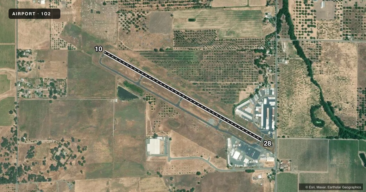
Airport sketch
Runways drawn to scale from FAA survey coordinates, rendered over satellite imagery. Not for navigation.
Approaches & charts
Services on the field
Fuel grades, oxygen, maintenance, ramp storage and lighting — as declared to the FAA by the airport operator.
Fuel & services
- Fuel
- 100LL
- Oxygen (bottled)
- Not available
- Oxygen (bulk)
- Not available
- Airframe repair
- Major
- Power plant repair
- Major
- Other services
- AMB,SALES
Ramp & ground
- Transient storage
- Tie-down
- Landing fee
- No fee published
- Customs
- Not available
- Lighting schedule
- SEE RMK
- Beacon schedule
- SS-SR
- Beacon
- White / Green (civil land)(WG)
- Wind indicator
- Lighted
- Segmented circle
- Yes
Fuel & FBOs
Cheapest 100LL and Jet A on the field and nearby. Always confirm with the FBO before taxi.
Airport notes
Surface conditions, obstructions, local procedures, lighting outages and other notes published with each FAA cycle.
General notes
- FOR CD CTC OAKLAND ARTCC AT 510-745-3380.
Lighting notes
- ACTVT MIRL RWY 10/28 - CTAF.
Approach & departure obstructions
- 28APCH RATIO TO DSPLCD THR 21:1.
Other notes
- MANAGERPRINCIPAL CIVIL ENGINEER; OFFICE IN LAKEPORT, CA.
VFR map & nearby airports
VFR sectional. Tap any ICAO chip to open that airport.
Key facts · 1O2
Answer card- ICAO
- 1O2
- Name
- LAMPSON FLD
- Location
- LAKEPORT, CALIFORNIA
- Elevation
- 1,380.1 ft MSL
- Traffic pattern altitude
- 2,180.1 ft MSL (800 AGL)
- Control tower
- Non-towered (use CTAF)
- Total runways
- 1
- Longest runway
- 10/28 · 3,600 ft
- Published ILS approaches
- 0
- Published frequencies
- 2
- Magnetic variation
- 16°
- Current flight rules
- VFR
- Current wind
- 000° at 0 kt
- Favored runway now
- –
Lampson Field sits in Lakeport, California. The field elevation is 1,380.1 ft MSL. It has one runway, 10/28, which is 3,600 ft long with an asphalt surface. The airport is non-towered. CTAF and UNICOM are both 122.8. The pattern altitude is 800 ft AGL, which is 2,180.1 ft MSL.
No ILS approaches are published here. Plan for a VFR or non-ILS arrival and check the current Chart Supplement before you go. Westgate Petroleum is on the field. It carries 100LL. Call (707) 263-6512 for current service details.
A few published remarks matter here. The runway lights on 10/28 are medium intensity and are activated by CTAF. For clearance delivery, contact Oakland ARTCC at 510-745-3380. There is also a published obstruction note for runway 28. The approach ratio to the displaced threshold is 21 to 1, so give that end a careful look on arrival. Lakeport sits inland near higher terrain around the field elevation, so expect density altitude to matter on warm days. Check the current Chart Supplement for any noise or operational notes before flying in.