METAR & TAF KUKI
Current METAR
Observed 12:56Z
KUKI 271256Z AUTO 00000KT 10SM CLR 12/09 A3001 RMK AO2 SLP157 T01170094
- Wind
- 000° @ 0 kt
- Visibility
- 10 SM
- Temp / Dew
- 12°C / 9°C
- Altimeter
- 30.01 inHg
- Clouds
- CLR
- Density alt
- 293 ft
- Ceiling
- Unlimited
- Rules
- VFR
Airport info & contacts
Manager on record, flight service, ARTCC, attendance schedule and pattern altitude — published by the FAA and refreshed every 28 days.
Location
- From city
- 1 NM S
- VFR sectional
- SAN FRANCISCO
- ARTCC
- ZOA · OAKLAND
- NOTAM facility
- UKI (NOTAM-D)
Airport manager
- Name
- GREG OWEN
- Phone
- 707-467-2855
- Address
- 1403 S. STATE STREET, UKIAH CA 95482
Flight service · Hours
- FSS OAK
- OAKLAND1-800-WX-BRIEF
- Attendance
- MAY · MON-FRI · 0800-1930
- MAY · SAT-SUN · 0930-1930
- JUN · MON-FRI · 0800-2000
- JUN · SAT-SUN · 0930-2000
- JUL-AUG · MON-FRI · 0800-2030
- JUL-AUG · SAT-SUN · 1000-2030
- SEP · MON-FRI · 0800-2000
- SEP · SAT-SUN · 0930-2000
- OCT · 0800-1930
- NOV · 0800-1800
- DEC-APR · 0800-1730
Frequencies
Tap any row to copy the frequency to your clipboard.
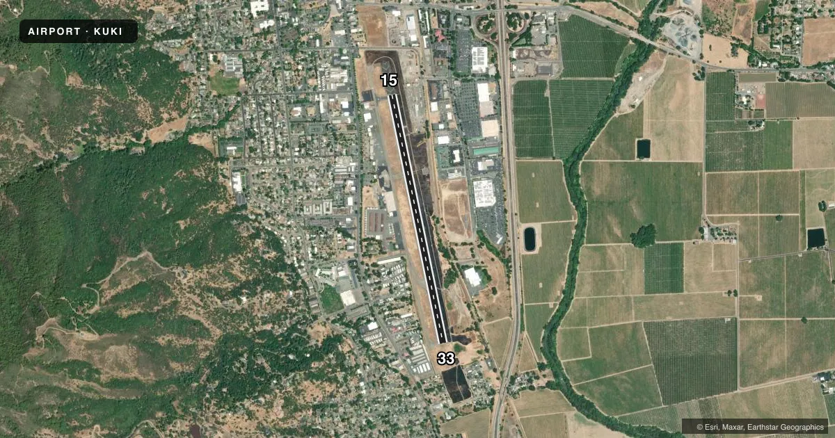
Runways & pattern
Full pagePattern entry · RWY 15
LEFT TRAFFICRunway end performance
| End | TORA | TODA | ASDA | LDA | VGSI | Approach lights | Obstruction |
|---|---|---|---|---|---|---|---|
| 15 | — | — | — | — | PAPI 4-box left(3°) | — | 27', trees, 950' from thr, 190' R of cntrln, slope 27 |
| 33 | — | — | — | — | — | — | 27', trees, 700' from thr, 135' R of cntrln, slope 18 |
Declared distances in feet. TORA = takeoff run available, TODA = takeoff distance, ASDA = accelerate-stop, LDA = landing distance.
Airport sketch
Runways drawn to scale from FAA survey coordinates, rendered over satellite imagery. Not for navigation.
Approaches & charts
ILS · 1
Services on the field
Fuel grades, oxygen, maintenance, ramp storage and lighting — as declared to the FAA by the airport operator.
Fuel & services
- Fuel
- 100LLA
- Oxygen (bottled)
- Not available
- Oxygen (bulk)
- High pressure
- Airframe repair
- Major
- Power plant repair
- Major
- Other services
- AMB,CHTR,INSTR,RNTL,SALES
Ramp & ground
- Transient storage
- Tie-down
- Landing fee
- Yes
- Customs
- Not available
- Lighting schedule
- SEE RMK
- Beacon schedule
- SEE RMK
- Beacon
- White / Green (civil land)(WG)
- Wind indicator
- Lighted
- Segmented circle
- Yes
Fuel & FBOs
Cheapest 100LL and Jet A on the field and nearby. Always confirm with the FBO before taxi.
Airport notes
Surface conditions, obstructions, local procedures, lighting outages and other notes published with each FAA cycle.
General notes
- <NO JET ACFT DEPARTURES BETWEEN 2200-0700 LCL.
- <CALM WIND RWY IS 15 FOR NOISE ABATEMENT REASONS.
- NOISE ABATEMENT PROCEDURES: AMGR REQUESTS NO VFR STRAIGHT-IN APCHS TO RY 15/33, RIGHT TURN AFTER DEP RY 33 TO AVOID OVERFLIGHT OF TOWN.
- FOR CD IF UNA TO CTC ON FSS FREQ, CTC OAKLAND ARTCC AT 510-745-3380.
Lighting notes
- SECOND ROTATING BCN ON MTN 250 DEGREES MAGNETIC & 2 MILES FM ARPT.
- DUSK-DAWN
- ACTVT PAPI RWY 15; REIL RWY 15 & 33; MIRL RWY 15/33 - CTAF.
Fuel notes
- 100LLSELF-SERVICE FUEL AVBL.
Other notes
- LNDG FEE FOR ALL ACFT OVR 12500 LBS.
VFR map & nearby airports
VFR sectional. Tap any ICAO chip to open that airport.
Key facts · KUKI
Answer card- ICAO
- KUKI
- Name
- UKIAH MUNI
- Location
- UKIAH, CALIFORNIA
- Elevation
- 616.8 ft MSL
- Traffic pattern altitude
- 1,616.8 ft MSL (1,000 AGL)
- Control tower
- Non-towered (use CTAF)
- Total runways
- 1
- Longest runway
- 15/33 · 4,423 ft
- Published ILS approaches
- 1
- Published frequencies
- 2
- Magnetic variation
- 13°
- Current flight rules
- VFR
- Current wind
- 000° at 0 kt
- Favored runway now
- –
Ukiah Muni sits in Ukiah, California. The field elevation is 616.8 ft MSL. It has one runway, 15/33, which is 4,423 ft long. There is no control tower. CTAF and UNICOM are both 123.0. The airport has one ILS approach to runway 15. Pattern altitude is not published, so use the standard 1,000 ft AGL for light piston traffic unless the current Chart Supplement says otherwise.
Ukiah Municipal Airport is the on-field FBO. It carries 100LL, Jet A and Jet A Prist. Self-serve 100LL is available. The airport manager asks pilots to avoid VFR straight-in approaches to runway 15 or 33. A right turn after departure from runway 33 is requested to reduce overflight of town. The calm wind runway is 15 for noise abatement. Lighting is on from dusk to dawn. PAPI for runway 15, REIL for both runway ends and MIRL for 15/33 are activated on CTAF.
There is also a rotating beacon on a mountain about 2 miles away at 250 degrees magnetic. Jet departures are not permitted between 2200 and 0700 local time. If you need clearance delivery and cannot reach FSS, Oakland ARTCC is listed as the backup contact. The airport also has a landing fee for aircraft over 12,500 pounds.