METAR & TAF O28
O28 does not publish a METAR.
Showing the nearest reporting station: KLLR (LITTLE RIVER) · 21.0 NM away. Conditions at O28 may differ.
METAR · KLLR
Observed 17:15Z
KLLR 261715Z AUTO 30008KT 10SM OVC007 17/14 A3007 RMK A01
- Wind
- 300° @ 8 kt
- Visibility
- 10 SM
- Temp / Dew
- 17°C / 14°C
- Altimeter
- 30.07 inHg
- Clouds
- OVC
- Density alt
- 2,616 ft
- Ceiling
- 700 ft AGL
- Rules
- IFR
Airport info & contacts
Manager on record, flight service, ARTCC, attendance schedule and pattern altitude — published by the FAA and refreshed every 28 days.
Location
- From city
- 3 NM NW
- VFR sectional
- SAN FRANCISCO
- ARTCC
- ZOA · OAKLAND
- NOTAM facility
- OAK (NOTAM-D)
Airport manager
- Name
- CATHY MOORHEAD
- Phone
- 707-459-7121
- Address
- 111 EAST COMMERCIAL STREET, WILLITS CA 95490
Flight service · Hours
- FSS OAK
- OAKLAND1-800-WX-BRIEF
- Attendance
- Unattended
Frequencies
Tap any row to copy the frequency to your clipboard.
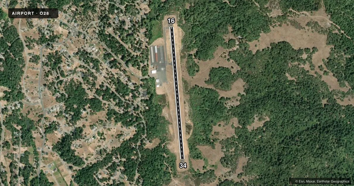
Runways & pattern
Full pagePattern entry · RWY 34
RIGHT TRAFFICRunway end performance
| End | TORA | TODA | ASDA | LDA | VGSI | Approach lights | Obstruction |
|---|---|---|---|---|---|---|---|
| 16 | — | — | — | — | — | — | 11', trees, 240' from thr, 80' R of cntrln, slope 3 |
| 34 | — | — | — | — | PAPI 2-box left(3°) | — | 38', trees, 1000' from thr, 200' R of cntrln, slope 21 |
Declared distances in feet. TORA = takeoff run available, TODA = takeoff distance, ASDA = accelerate-stop, LDA = landing distance.
Airport sketch
Runways drawn to scale from FAA survey coordinates, rendered over satellite imagery. Not for navigation.
Approaches & charts
Services on the field
Fuel grades, oxygen, maintenance, ramp storage and lighting — as declared to the FAA by the airport operator.
Fuel & services
- Fuel
- 100LL
- Airframe repair
- Minor
- Power plant repair
- Minor
- Other services
- CHTR,INSTR,RNTL,SALES
Ramp & ground
- Transient storage
- Tie-down
- Landing fee
- No fee published
- Customs
- Not available
- Lighting schedule
- SEE RMK
- Beacon schedule
- SEE RMK
- Beacon
- White / Green (civil land)(WG)
- Wind indicator
- Lighted
- Segmented circle
- Yes
Fuel & FBOs
Cheapest 100LL and Jet A on the field and nearby. Always confirm with the FBO before taxi.
Airport notes
Surface conditions, obstructions, local procedures, lighting outages and other notes published with each FAA cycle.
General notes
- DEER AND TURKEYS ON AND INVOF RY.
- ACFT NOT VISIBLE FROM OPPOSITE ENDS OF THE RUNWAY.
- FOR CD CTC OAKLAND ARTCC AT 510-745-3380.
Lighting notes
- DUSK-DAWN. BCN OTS INDEFLY.
- ACTVT PAPI RWY 34; MIRL RWY 16/34 - CTAF.
Fuel notes
- 100LLFUEL AVBL 24 HRS WITH CREDIT CARD.
Other notes
- MANAGEREMAIL: KOSHEA@WILLITSAIRPORT.COM
- INSTRBANNER TOWING
VFR map & nearby airports
VFR sectional. Tap any ICAO chip to open that airport.
Key facts · O28
Answer card- ICAO
- O28
- Name
- ELLS FLD/WILLITS MUNI
- Location
- WILLITS, CALIFORNIA
- Elevation
- 2,065.9 ft MSL
- Traffic pattern altitude
- 3,065.9 ft MSL (1,000 AGL)
- Control tower
- Non-towered (use CTAF)
- Total runways
- 1
- Longest runway
- 16/34 · 2,705 ft
- Published ILS approaches
- 0
- Published frequencies
- 2
- Magnetic variation
- 16°
- Current flight rules
- IFR
- Current wind
- 300° at 8 kt
- Favored runway now
- RWY 34
Ells Fld/Willits Muni is in Willits, California. The field elevation is 2,065.9 ft MSL. It has one runway, 16/34, which is 2,705 ft long and paved asphalt. There is no control tower. CTAF and UNICOM are both 122.8. No ILS approaches are published here.
The pattern altitude is not published. For light piston operations, plan on the standard 1,000 ft AGL unless the current Chart Supplement says otherwise. The on-field FBO is Willits Municipal Airport. It carries AVGAS 100LL. 100LL is available 24 hours with a credit card. The published remarks also note that runway 34 has a PAPI. Medium intensity runway lights are available on runways 16 and 34. The beacon is out of service indefinitely.
This is a non-towered field with a single short runway at a fairly high field elevation. Expect to pay attention to density altitude, runway performance and traffic calls. Deer and turkeys are reported on and near the runway. Aircraft are not visible from opposite ends of the runway, so keep your scan active in the pattern. For clearance delivery, contact Oakland ARTCC. Check the current FAA Chart Supplement for any updated remarks before you go.