METAR & TAF O09
O09 does not publish a METAR.
Showing the nearest reporting station: KLLR (LITTLE RIVER) · 38.9 NM away. Conditions at O09 may differ.
METAR · KLLR
Observed 12:15Z
KLLR 271215Z AUTO 33004KT 10SM OVC006 14/13 A3004 RMK A01
- Wind
- 330° @ 4 kt
- Visibility
- 10 SM
- Temp / Dew
- 14°C / 13°C
- Altimeter
- 30.04 inHg
- Clouds
- OVC
- Density alt
- 1,509 ft
- Ceiling
- 600 ft AGL
- Rules
- IFR
Airport info & contacts
Manager on record, flight service, ARTCC, attendance schedule and pattern altitude — published by the FAA and refreshed every 28 days.
Location
- From city
- 1 NM SW
- VFR sectional
- SAN FRANCISCO
- Pattern altitude
- 800 ft AGL · 2,234 ft MSL
- ARTCC
- ZOA · OAKLAND
- NOTAM facility
- OAK (NOTAM-D)
Airport manager
- Name
- HOWARD DASHIELL
- Phone
- 707-463-4363
- Address
- 340 LAKE MENDOCINO DRIVE, UKIAH CA 95482-9432
Flight service · Hours
- FSS OAK
- OAKLAND1-800-WX-BRIEF
- Attendance
- Unattended
Frequencies
Tap any row to copy the frequency to your clipboard.
Runways & pattern
Full pagePattern entry · RWY 28
RIGHT TRAFFICRunway end performance
| End | TORA | TODA | ASDA | LDA | VGSI | Approach lights | Obstruction |
|---|---|---|---|---|---|---|---|
| 10 | — | — | — | — | — | — | 250', hill, 2500' from thr, 100' R of cntrln, slope 9 |
| 28 | — | — | — | — | — | — | 100', trees, 3500' from thr, 0' R of cntrln, slope 33 |
Declared distances in feet. TORA = takeoff run available, TODA = takeoff distance, ASDA = accelerate-stop, LDA = landing distance.
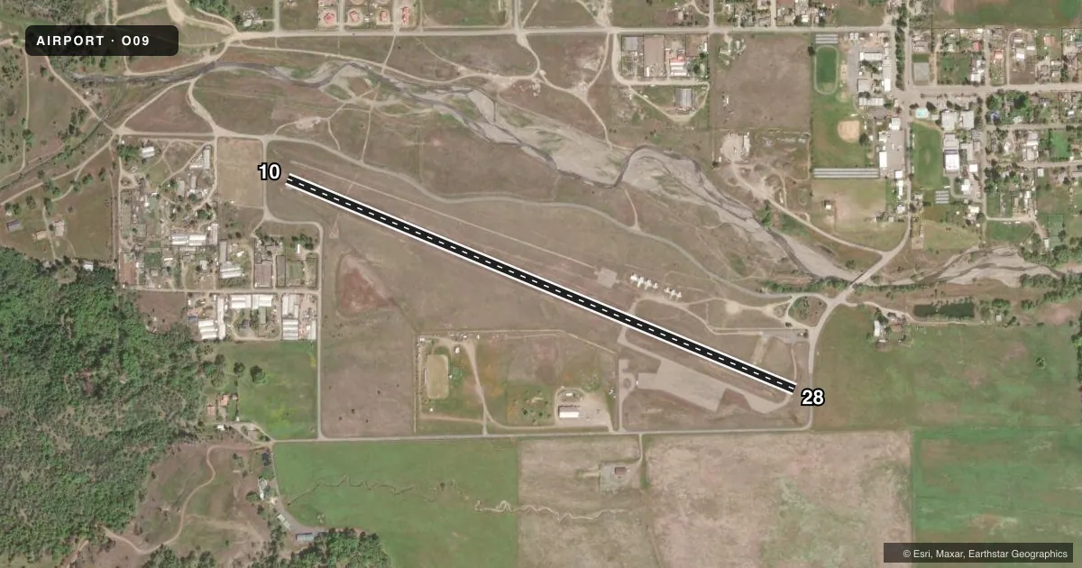
Airport sketch
Runways drawn to scale from FAA survey coordinates, rendered over satellite imagery. Not for navigation.
Approaches & charts
Services on the field
Fuel grades, oxygen, maintenance, ramp storage and lighting — as declared to the FAA by the airport operator.
Fuel & services
- Fuel
- 100LL
- Oxygen (bottled)
- Not available
- Oxygen (bulk)
- Not available
- Airframe repair
- Not available
- Power plant repair
- Not available
Ramp & ground
- Transient storage
- Tie-down
- Landing fee
- No fee published
- Customs
- Not available
- Lighting schedule
- SEE RMK
- Beacon schedule
- SEE RMK
- Beacon
- White / Green (civil land)(WG)
- Wind indicator
- Lighted
- Segmented circle
- Yes
Fuel & FBOs
Cheapest 100LL and Jet A on the field and nearby. Always confirm with the FBO before taxi.
Airport notes
Surface conditions, obstructions, local procedures, lighting outages and other notes published with each FAA cycle.
General notes
- FOR CD CTC OAKLAND ARTCC AT 510-745-3380.
- ARPT IN VALLEY; HIGH MTS AND TRRN AND RIDGE SRND ARPT. MT FLYING EXPERIENCE STRONGLY RCMDD.
Lighting notes
- DUSK-DAWN.
- FOR MIRL RWY 10/28 KEY 122.8 5 TIMES.
Approach & departure obstructions
- 10ROAD 100 FT FM THR & 4 FT FENCE 135 FT FM THR; 3 FT TIRES 80 FT 0B FM THR.
- 28ROAD 50 FT FM THR; 4 FT FENCE 40 FT FM THR; 5 FT FENCE 110 FT FM THR.
- 10APCH RATIO 10:1 TO DSPLCD THLD.
- 28APCH RATIO TO DSPLCD THR 37:1; APCH RATIO TO DSPLCD THR OVER +15 FT ROAD 310 FT FM DSPLCD THR 20:1.
Other notes
- MANAGERADD'L AUTH SOURCE, HOWARD DASHIELL, DIR MCDOT (707) 463-4363, BOB MORGAN (MORGANB@CO.MENDOCINO.CA.US) ENG MCDOT (707) 463-5494
VFR map & nearby airports
VFR sectional. Tap any ICAO chip to open that airport.
Key facts · O09
Answer card- ICAO
- O09
- Name
- ROUND VALLEY
- Location
- COVELO, CALIFORNIA
- Elevation
- 1,434 ft MSL
- Traffic pattern altitude
- 2,234 ft MSL (800 AGL)
- Control tower
- Non-towered (use CTAF)
- Total runways
- 1
- Longest runway
- 10/28 · 3,670 ft
- Published ILS approaches
- 0
- Published frequencies
- 2
- Magnetic variation
- 17°
- Current flight rules
- IFR
- Current wind
- 330° at 4 kt
- Favored runway now
- RWY 28
Round Valley Airport sits in Covelo, California. The field elevation is 1,434 ft MSL. It has one runway, 10/28, which is 3,670 ft long. There is no control tower. Pattern altitude is 800 ft AGL, which is 2,234 ft MSL.
No ILS approaches are published here. CTAF and UNICOM are both 122.8. Round Valley Airport is on the field. It carries 100LL. Call (707) 463-4363 for current service details.
This is a valley airport with high mountains, terrain and ridges around it. Mountain flying experience is strongly recommended. The published remarks also call out displaced threshold and obstacle issues on both ends of runway 10/28. Runway 28 has roads and fences close to the threshold. Runway 10 has a road, a fence and tires near the runway environment. Beacon lighting is available from dusk to dawn. Medium intensity runway lighting on 10/28 is activated by keying 122.8 five times. For clearance delivery, contact Oakland ARTCC. Check the current FAA Chart Supplement for any updated operating notes before you go.