METAR & TAF 0Q5
0Q5 does not publish a METAR.
Showing the nearest reporting station: KFOT (ROHNERVILLE) · 31.7 NM away. Conditions at 0Q5 may differ.
METAR · KFOT
Observed 12:50Z
KFOT 271250Z AUTO 00000KT 10SM OVC009 13/13 A3008 RMK AO1
- Wind
- 000° @ 0 kt
- Visibility
- 10 SM
- Temp / Dew
- 13°C / 13°C
- Altimeter
- 30.08 inHg
- Clouds
- OVC
- Density alt
- -347 ft
- Ceiling
- 900 ft AGL
- Rules
- IFR
Airport info & contacts
Manager on record, flight service, ARTCC, attendance schedule and pattern altitude — published by the FAA and refreshed every 28 days.
Location
- From city
- 1 NM W
- VFR sectional
- KLAMATH FALLS
- ARTCC
- ZOA · OAKLAND
- NOTAM facility
- OAK (NOTAM-D)
Airport manager
- Name
- CHISTOPHER CHRISTIANSON
- Phone
- (707) 986-7447
- Address
- 9126 SHELTER COVE ROAD, WHITEHORN CA 95589
Flight service · Hours
- FSS OAK
- OAKLAND1-800-WX-BRIEF
- Attendance
- Unattended
Frequencies
Tap any row to copy the frequency to your clipboard.
Runways & pattern
Full pagePattern entry · RWY 12
RIGHT TRAFFICRunway end performance
| End | TORA | TODA | ASDA | LDA | VGSI | Approach lights | Obstruction |
|---|---|---|---|---|---|---|---|
| 12 | — | — | — | — | — | — | 10', tree, 400' from thr, 150' R of cntrln, slope 20 |
| 30 | — | — | — | — | — | — | 60', tree, 1000' from thr, 190' R of cntrln, slope 13 |
Declared distances in feet. TORA = takeoff run available, TODA = takeoff distance, ASDA = accelerate-stop, LDA = landing distance.
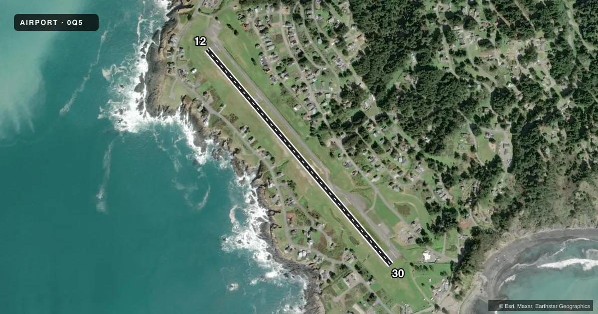
Airport sketch
Runways drawn to scale from FAA survey coordinates, rendered over satellite imagery. Not for navigation.
Approaches & charts
Services on the field
Fuel grades, oxygen, maintenance, ramp storage and lighting — as declared to the FAA by the airport operator.
Fuel & services
- Fuel
- Not available
- Airframe repair
- Not available
- Power plant repair
- Not available
Ramp & ground
- Transient storage
- Tie-down
- Landing fee
- No fee published
- Customs
- Not available
- Wind indicator
- Yes
- Segmented circle
- Yes
Fuel & FBOs
Cheapest 100LL and Jet A on the field and nearby. Always confirm with the FBO before taxi.
Airport notes
Surface conditions, obstructions, local procedures, lighting outages and other notes published with each FAA cycle.
General notes
- ARPT USE RESTRICTED BY AMGR TO ACFT HAVING A MAXIMUM CERTIFICATED GROSS TKOF WGT OF 12,500 LBS OR LESS; CTC AMGR FOR ADDITIONAL INFO (707)986-7447.
- STUDENT PILOT SOLO FLIGHTS PROHIBITED.
- NO PRACTICE LOW APCHS OR TOUCH AND GO LANDINGS.
- BE ALERT FOR ULTRA-LIGHTS, HANGLIDERS AND PARACHUTERS INVOF ARPT.
- GOLF CARTS OPERATING ON AND INVOF ARPT.
- EXPECT CROSSWINDS, DOWNDRAFTS AND EXTDD PERIODS OF FOG YEAR-ROUND.
- TERRAIN +40 FT DROP OFF LCTD 500 FT NORTH RY 12 END.
- FOR CD CTC OAKLAND ARTCC AT 510-745-3380.
Approach & departure obstructions
- 30APCH RATIO 22:1 TO DSPLCD THLD, 37 FT TREE 191 FT R 341 FT FM EOR..
VFR map & nearby airports
VFR sectional. Tap any ICAO chip to open that airport.
Key facts · 0Q5
Answer card- ICAO
- 0Q5
- Name
- SHELTER COVE
- Location
- SHELTER COVE, CALIFORNIA
- Elevation
- 73.4 ft MSL
- Traffic pattern altitude
- 1,073.4 ft MSL (1,000 AGL)
- Control tower
- Non-towered (use CTAF)
- Total runways
- 1
- Longest runway
- 12/30 · 3,407 ft
- Published ILS approaches
- 0
- Published frequencies
- 1
- Magnetic variation
- 17°
- Current flight rules
- IFR
- Current wind
- 000° at 0 kt
- Favored runway now
- –
Shelter Cove Airport (0Q5) sits in Shelter Cove, California on the North Coast. Field elevation is 73.4 ft MSL. The airport has one runway, 12/30, at 3,407 ft of asphalt. There is no control tower. CTAF is 122.9. No ILS approaches are published.
The Chart Supplement does not publish a pattern altitude here. Use the standard 1,000 ft AGL pattern for light piston traffic unless the current Chart Supplement or airport manager says otherwise. This is a coastal strip with weather that can change fast. Expect crosswinds, downdrafts and long stretches of fog year-round. Terrain rises near the field. There is also a drop off north of runway 12. Keep that in mind on departure and when setting up for final.
Published remarks also call out ultralights, hang gliders and parachuters in the area. No practice low approaches or touch-and-go landings are permitted. Student pilot solo flights are prohibited. Airport use is limited to aircraft with a maximum certificated gross takeoff weight of 12,500 pounds or less. There are no on-field FBOs listed in the facts. Verify services with the airport operator or the FBO directly by phone before you go.