METAR & TAF H47
H47 does not publish a METAR.
Showing the nearest reporting station: KFOT (ROHNERVILLE) · 30.6 NM away. Conditions at H47 may differ.
METAR · KFOT
Observed 05:10Z
KFOT 270510Z AUTO 35007KT 10SM OVC013 14/14 A3012 RMK AO1
- Wind
- 350° @ 7 kt
- Visibility
- 10 SM
- Temp / Dew
- 14°C / 14°C
- Altimeter
- 30.12 inHg
- Clouds
- OVC
- Density alt
- 1,215 ft
- Ceiling
- 1,300 ft AGL
- Rules
- MVFR
Airport info & contacts
Manager on record, flight service, ARTCC, attendance schedule and pattern altitude — published by the FAA and refreshed every 28 days.
Location
- From city
- 1 NM NW
- VFR sectional
- KLAMATH FALLS
- Pattern altitude
- 800 ft AGL · 2,077 ft MSL
- ARTCC
- ZOA · OAKLAND
- NOTAM facility
- OAK (NOTAM-D)
Airport manager
- Name
- PANOS KOKKAS
- Phone
- 530-623-1365
- Address
- P.O. BOX 2490, WEAVERVILLE CA 96093-2490
Flight service · Hours
- FSS OAK
- OAKLAND1-800-WX-BRIEF
- Attendance
- Unattended
Frequencies
Tap any row to copy the frequency to your clipboard.
Runways & pattern
Full pagePattern entry · RWY 32
LEFT TRAFFICRunway end performance
| End | TORA | TODA | ASDA | LDA | VGSI | Approach lights | Obstruction |
|---|---|---|---|---|---|---|---|
| 32 | — | — | — | — | — | — | 79', trees, 525' from thr, 0' R of cntrln, slope 4 |
Declared distances in feet. TORA = takeoff run available, TODA = takeoff distance, ASDA = accelerate-stop, LDA = landing distance.
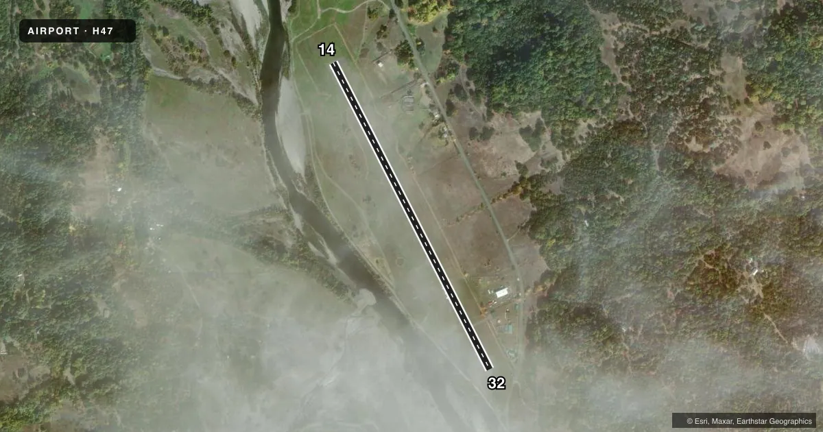
Airport sketch
Runways drawn to scale from FAA survey coordinates, rendered over satellite imagery. Not for navigation.
Approaches & charts
Services on the field
Fuel grades, oxygen, maintenance, ramp storage and lighting — as declared to the FAA by the airport operator.
Fuel & services
- Fuel
- Not available
Ramp & ground
- Transient storage
- Tie-down
- Landing fee
- No fee published
- Customs
- Not available
- Wind indicator
- Yes
- Segmented circle
- Yes
Fuel & FBOs
Cheapest 100LL and Jet A on the field and nearby. Always confirm with the FBO before taxi.
Airport notes
Surface conditions, obstructions, local procedures, lighting outages and other notes published with each FAA cycle.
General notes
- ARPT CLSD NGTS.
- HIGH TERRAIN ALL QUADRANTS.
- INTERMITTENTLY CLOSED WINTERS DUE TO SNOW. CONTACT COUNTY TRANSPORTATION OFFICE FOR INFO 530-623-1365.
- FOR CD CTC OAKLAND ARTCC AT 510-745-3380.
Approach & departure obstructions
- 32APCH RATIO 17:1 TO DSPLCD THLD.
Other notes
- MANAGERDIRECTOR OF TRANSPORTATION; OFFICE IN WEAVERVILLE.
- OWNERTRINITY COUNTY TRANSPORTATION SERVICES OFFICE IN WEAVERVILLE.
VFR map & nearby airports
VFR sectional. Tap any ICAO chip to open that airport.
Key facts · H47
Answer card- ICAO
- H47
- Name
- HYAMPOM
- Location
- HYAMPOM, CALIFORNIA
- Elevation
- 1,277 ft MSL
- Traffic pattern altitude
- 2,077 ft MSL (800 AGL)
- Control tower
- Non-towered (use CTAF)
- Total runways
- 1
- Longest runway
- 14/32 · 2,980 ft
- Published ILS approaches
- 0
- Published frequencies
- 2
- Magnetic variation
- 17°
- Current flight rules
- MVFR
- Current wind
- 350° at 7 kt
- Favored runway now
- RWY 32
Hyampom Airport sits in Hyampom, California. Field elevation is 1,277 ft MSL. The airport has one runway. Runway 14/32 is 2,980 ft long and paved with asphalt. There is no control tower. CTAF and UNICOM are both 122.8.
Pattern altitude is 800 ft AGL, which puts the traffic pattern at 2,077 ft MSL. No ILS approaches are published here. The field is closed at night. Winter use can be limited too. The airport is intermittently closed in winter because of snow, so check with the county transportation office before you go. High terrain exists in all quadrants around the airport. That matters here. Plan your arrival with terrain in mind and keep an eye on the charted environment.
There are no on-field FBOs listed. If you need current services, contact the airport operator directly. For clearance delivery, Oakland ARTCC is listed in the remarks. Runway 32 also has a published displaced-threshold note with a 17 to 1 approach slope ratio. That is worth checking before you plan a landing from that direction.