METAR & TAF O19
O19 does not publish a METAR.
Showing the nearest reporting station: KFOT (ROHNERVILLE) · 13.6 NM away. Conditions at O19 may differ.
METAR · KFOT
Observed 06:30Z
KFOT 270630Z AUTO 01005KT 10SM OVC015 14/14 A3011 RMK AO1
- Wind
- 010° @ 5 kt
- Visibility
- 10 SM
- Temp / Dew
- 14°C / 14°C
- Altimeter
- 30.11 inHg
- Clouds
- OVC
- Density alt
- 3,043 ft
- Ceiling
- 1,500 ft AGL
- Rules
- MVFR
Airport info & contacts
Manager on record, flight service, ARTCC, attendance schedule and pattern altitude — published by the FAA and refreshed every 28 days.
Location
- From city
- 10 NM SE
- VFR sectional
- KLAMATH FALLS
- Pattern altitude
- 800 ft AGL · 3,541 ft MSL
- ARTCC
- ZSE · SEATTLE
- NOTAM facility
- OAK (NOTAM-D)
Airport manager
- Name
- JUSTIN HOPMAN
- Phone
- 707-382-2551
- Address
- 3561 BOEING AVE., MCKINLEYVILLE CA 95519
Flight service · Hours
- FSS OAK
- OAKLAND1-800-WX-BRIEF
- Attendance
- Unattended
Frequencies
Tap any row to copy the frequency to your clipboard.
Runways & pattern
Full pagePattern entry · RWY 33
LEFT TRAFFICRunway end performance
| End | TORA | TODA | ASDA | LDA | VGSI | Approach lights | Obstruction |
|---|---|---|---|---|---|---|---|
| 15 | — | — | — | — | — | — | 8', trees, 230' from thr, 70' R of cntrln, slope 3 |
| 33 | — | — | — | — | — | — | 79', trees, 2500' from thr, 200' R of cntrln, slope 29 |
Declared distances in feet. TORA = takeoff run available, TODA = takeoff distance, ASDA = accelerate-stop, LDA = landing distance.
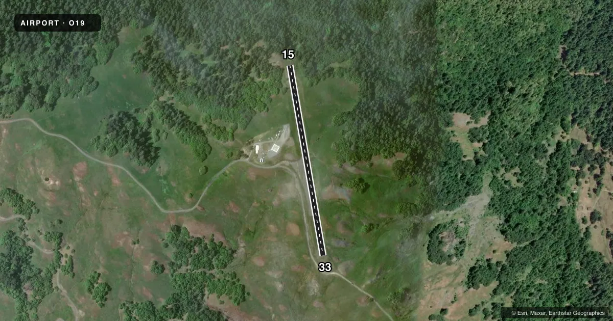
Airport sketch
Runways drawn to scale from FAA survey coordinates, rendered over satellite imagery. Not for navigation.
Approaches & charts
Services on the field
Fuel grades, oxygen, maintenance, ramp storage and lighting — as declared to the FAA by the airport operator.
Fuel & services
- Fuel
- Not available
- Oxygen (bottled)
- Not available
- Oxygen (bulk)
- Not available
- Airframe repair
- Not available
- Power plant repair
- Not available
Ramp & ground
- Transient storage
- Tie-down
- Landing fee
- No fee published
- Customs
- Not available
- Wind indicator
- Yes
- Segmented circle
- No
Fuel & FBOs
Cheapest 100LL and Jet A on the field and nearby. Always confirm with the FBO before taxi.
Airport notes
Surface conditions, obstructions, local procedures, lighting outages and other notes published with each FAA cycle.
General notes
- CA DEPT OF FORESTRY HELIPORT ADJACENT TO ARPT ON WEST SIDE.
- DAY USE ONLY; CLSD NGTS.
- 500 FT DROP OFF 25 FT FM RY 15 THR; 40 FT DROP OFF 40 FT FM RY 33 THR.
- FOR CD CTC SEATTLE ARTCC AT 253-351-3694.
Approach & departure obstructions
- 15APCH RATIO 28:1 TO DSPLCD THLD.
- 33APCH RATIO 32:1 TO DSPLCD THR.
VFR map & nearby airports
VFR sectional. Tap any ICAO chip to open that airport.
Key facts · O19
Answer card- ICAO
- O19
- Name
- KNEELAND
- Location
- EUREKA, CALIFORNIA
- Elevation
- 2,741 ft MSL
- Traffic pattern altitude
- 3,541 ft MSL (800 AGL)
- Control tower
- Non-towered (use CTAF)
- Total runways
- 1
- Longest runway
- 15/33 · 2,250 ft
- Published ILS approaches
- 0
- Published frequencies
- 1
- Magnetic variation
- 17°
- Current flight rules
- MVFR
- Current wind
- 010° at 5 kt
- Favored runway now
- RWY 33
Kneeland Airport (O19) sits near Eureka, California in the coastal hills. Field elevation is 2,741 ft MSL. The airport has one runway. Runway 15/33 is 2,250 ft long with an asphalt surface. There is no control tower. CTAF is 122.9.
No ILS approaches are published here. Pattern altitude is 800 ft AGL, which is 3,541 ft MSL. That matters here because the field is already high. Expect mountain flying judgment on arrival and departure. The published remarks also call out steep drop-offs near both runway ends. Runway 15 has a 500-foot drop off close to the threshold. Runway 33 has a 40-foot drop off near the threshold. The airport is day use only. It is closed at night.
There are no on-field FBOs listed. Plan on self-sufficiency and verify current services with the airport operator before you go. The California Department of Forestry heliport is adjacent on the west side. For clearance delivery, contact Seattle ARTCC at 253-351-3694. If you are planning a first visit, check the current FAA Chart Supplement for any updated operational notes before flying in.