METAR & TAF O33
O33 does not publish a METAR.
Showing the nearest reporting station: KACV (CALIFORNIA REDWOOD COAST-HUMBOLDT COUNTY) · 12.7 NM away. Conditions at O33 may differ.
METAR · KACV
Observed 03:53Z
KACV 270353Z AUTO 34006KT 10SM CLR 14/12 A3009 RMK AO2 SLP195 T01440122
- Wind
- 340° @ 6 kt
- Visibility
- 10 SM
- Temp / Dew
- 14°C / 12°C
- Altimeter
- 30.09 inHg
- Clouds
- CLR
- Density alt
- -306 ft
- Ceiling
- Unlimited
- Rules
- VFR
Airport info & contacts
Manager on record, flight service, ARTCC, attendance schedule and pattern altitude — published by the FAA and refreshed every 28 days.
Location
- From city
- 2 NM W
- VFR sectional
- KLAMATH FALLS
- Pattern altitude
- 800 ft AGL · 820 ft MSL
- ARTCC
- ZSE · SEATTLE
- NOTAM facility
- OAK (NOTAM-D)
Airport manager
- Name
- JEFFREY RAIMEY
- Phone
- 707-441-4374
- Address
- CITY OF EUREKA, ENGINEERING DEPT., 531 K STREET, EUREKA CA 95501-1146
Flight service · Hours
- FSS OAK
- OAKLAND1-800-WX-BRIEF
- Attendance
- Unattended
Frequencies
Tap any row to copy the frequency to your clipboard.
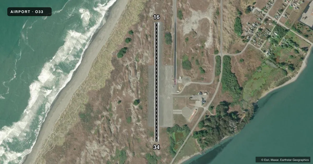
Runways & pattern
Full pagePattern entry · RWY 34
LEFT TRAFFICAirport sketch
Runways drawn to scale from FAA survey coordinates, rendered over satellite imagery. Not for navigation.
Approaches & charts
Services on the field
Fuel grades, oxygen, maintenance, ramp storage and lighting — as declared to the FAA by the airport operator.
Fuel & services
- Fuel
- Not available
- Oxygen (bottled)
- Not available
- Oxygen (bulk)
- Not available
- Airframe repair
- Not available
- Power plant repair
- Not available
Ramp & ground
- Transient storage
- Tie-down
- Landing fee
- No fee published
- Customs
- Not available
- Wind indicator
- Yes
- Segmented circle
- Yes
Fuel & FBOs
Cheapest 100LL and Jet A on the field and nearby. Always confirm with the FBO before taxi.
Airport notes
Surface conditions, obstructions, local procedures, lighting outages and other notes published with each FAA cycle.
General notes
- DAY USE ONLY; CLSD NGTS.
- BE AWARE, CTAF FREQ SHARED WITH NEARBY ARPT.
- FOR CD CTC SEATTLE ARTCC AT 253-351-3694.
Lighting notes
- ULTRALIGHT ACTIVITY ON & INVOF ARPT.
Other notes
- ESTABD PRIOR TO 1959.
- OWNERDIRECTOR OFFICE, EUREKA CITY HALL.
VFR map & nearby airports
VFR sectional. Tap any ICAO chip to open that airport.
Key facts · O33
Answer card- ICAO
- O33
- Name
- SAMOA FLD
- Location
- EUREKA, CALIFORNIA
- Elevation
- 20 ft MSL
- Traffic pattern altitude
- 820 ft MSL (800 AGL)
- Control tower
- Non-towered (use CTAF)
- Total runways
- 1
- Longest runway
- 16/34 · 2,700 ft
- Published ILS approaches
- 0
- Published frequencies
- 1
- Magnetic variation
- 17°
- Current flight rules
- VFR
- Current wind
- 340° at 6 kt
- Favored runway now
- RWY 34
Samoa Fld is in Eureka, California. The field elevation is 20 ft MSL. It has one runway, 16/34, which is 2,700 ft long with an asphalt surface. There is no control tower. CTAF is 122.7. The published pattern altitude is 800 ft AGL, which is 820 ft MSL.
No ILS approaches are published here. That matters if the marine layer is hanging around the coast. Plan with current weather and the current Chart Supplement before you go. The airport is day use only. It is closed at night. Ultralight activity is published on and near the airport, so keep a sharp lookout in the pattern and on final. The CTAF is shared with a nearby airport, so listen carefully before keying up.
There are no on-field FBOs listed in the facts. If you need fuel or other services, contact the airport operator directly before arrival or call the field on CTAF for current availability. For clearance delivery, the published contact is Seattle ARTCC at 253-351-3694. The airport is established prior to 1959. The director office is at Eureka City Hall.