METAR & TAF D63
D63 does not publish a METAR.
Showing the nearest reporting station: KFOT (ROHNERVILLE) · 24.7 NM away. Conditions at D63 may differ.
METAR · KFOT
Observed 10:50Z
KFOT 271050Z AUTO 00000KT 10SM OVC013 13/13 A3008 RMK AO1
- Wind
- 000° @ 0 kt
- Visibility
- 10 SM
- Temp / Dew
- 13°C / 13°C
- Altimeter
- 30.08 inHg
- Clouds
- OVC
- Density alt
- 2,529 ft
- Ceiling
- 1,300 ft AGL
- Rules
- MVFR
Airport info & contacts
Manager on record, flight service, ARTCC, attendance schedule and pattern altitude — published by the FAA and refreshed every 28 days.
Location
- From city
- 1 NM E
- VFR sectional
- KLAMATH FALLS
- Pattern altitude
- 900 ft AGL · 3,293 ft MSL
- ARTCC
- ZSE · SEATTLE
- NOTAM facility
- OAK (NOTAM-D)
Airport manager
- Name
- JUSTIN HOPMAN
- Phone
- 707-382-2551
- Address
- 3561 BOEING AVE., MCKINLEYVILLE CA 95519
Flight service · Hours
- FSS OAK
- OAKLAND1-800-WX-BRIEF
- Attendance
- Unattended
Frequencies
Tap any row to copy the frequency to your clipboard.
Runways & pattern
Full pagePattern entry · RWY 09
RIGHT TRAFFICRunway end performance
| End | TORA | TODA | ASDA | LDA | VGSI | Approach lights | Obstruction |
|---|---|---|---|---|---|---|---|
| 09 | — | — | — | — | — | — | 150', trees, 525' from thr, 0' R of cntrln, slope 2 |
| 27 | — | — | — | — | — | — | 15', road, 200' from thr, 0' R of cntrln, slope 0 |
Declared distances in feet. TORA = takeoff run available, TODA = takeoff distance, ASDA = accelerate-stop, LDA = landing distance.
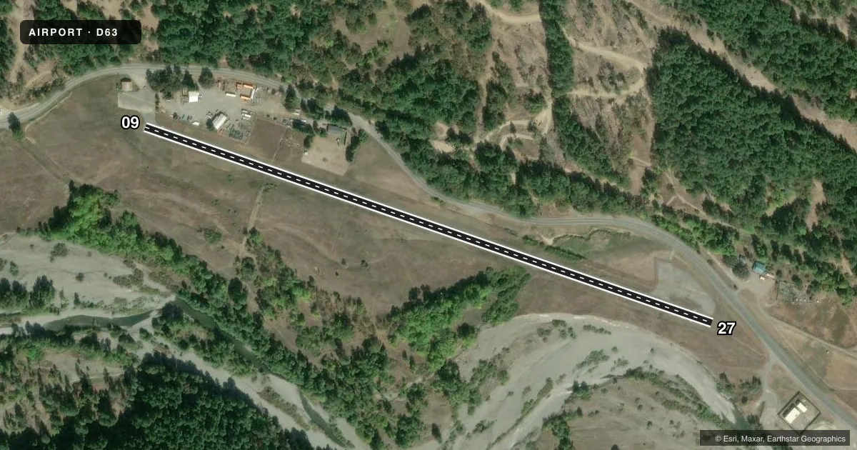
Airport sketch
Runways drawn to scale from FAA survey coordinates, rendered over satellite imagery. Not for navigation.
Approaches & charts
Services on the field
Fuel grades, oxygen, maintenance, ramp storage and lighting — as declared to the FAA by the airport operator.
Fuel & services
- Fuel
- Not available
- Oxygen (bottled)
- Not available
- Oxygen (bulk)
- Not available
- Airframe repair
- Not available
- Power plant repair
- Not available
Ramp & ground
- Transient storage
- Tie-down
- Landing fee
- No fee published
- Customs
- Not available
- Wind indicator
- Yes
- Segmented circle
- Yes
Fuel & FBOs
Cheapest 100LL and Jet A on the field and nearby. Always confirm with the FBO before taxi.
Airport notes
Surface conditions, obstructions, local procedures, lighting outages and other notes published with each FAA cycle.
General notes
- DAY USE ONLY; CLSD NGTS.
- MOUNTAINS WITH HIGH TREES INVOF ARPT.
- FOR CD CTC SEATTLE ARTCC AT 253-351-3694.
- DEER IN VCNTY OF RWY.
Approach & departure obstructions
- 2715' ROAD AT 40' FM THR 125' R; +5' FENCE AT 0' FM THR 125' R.
- 09APCH RATIO 4:1 TO DSPLCD THR.
- 27APCH RATIO 18:1 TO DSPLCD THR; APCH RATIO 6:1 OVER +340' TREES 2080' FM DSPLCD THR.
Other notes
- ESTABD PRIOR TO 1959.
- MANAGERAIRPORT MANAGER LOCATED AT ARCATA/EUREKA AIRPORT.
VFR map & nearby airports
VFR sectional. Tap any ICAO chip to open that airport.
Key facts · D63
Answer card- ICAO
- D63
- Name
- DINSMORE
- Location
- DINSMORE, CALIFORNIA
- Elevation
- 2,392.8 ft MSL
- Traffic pattern altitude
- 3,292.8 ft MSL (900 AGL)
- Control tower
- Non-towered (use CTAF)
- Total runways
- 1
- Longest runway
- 09/27 · 2,504 ft
- Published ILS approaches
- 0
- Published frequencies
- 1
- Magnetic variation
- 17°
- Current flight rules
- MVFR
- Current wind
- 000° at 0 kt
- Favored runway now
- –
Dinsmore Airport sits in Dinsmore, California. The field elevation is 2,392.8 ft MSL. It has one runway. Runway 09/27 is 2,504 ft of asphalt, so plan for a short-field profile if you are bringing in anything larger than a light single. There is no control tower. CTAF is 122.9. No ILS approaches are published here.
Pattern altitude is 900 ft AGL, which puts the traffic pattern at 3,292.8 ft MSL. The airport is day use only. It is closed at night. Deer are reported in the vicinity of the runway. Mountains with high trees are also nearby, so expect terrain and obstacle awareness to matter on arrival and departure.
There are no on-field FBOs listed. Check with the airport operator or the FBO directly by phone if you need current services before you go. Published remarks also note obstruction issues near both runway ends. Runway 27 has a displaced threshold with trees close in on the approach path. Runway 09 has a steeper approach path over the displaced threshold. For clearance delivery, contact Seattle ARTCC. The airport manager is located at Arcata/Eureka Airport.