METAR & TAF T42
T42 does not publish a METAR.
Showing the nearest reporting station: KFOT (ROHNERVILLE) · 43.4 NM away. Conditions at T42 may differ.
METAR · KFOT
Observed 21:30Z
KFOT 262130Z AUTO 30014G17KT 10SM CLR 20/14 A3009 RMK AO1
- Wind
- 300° @ 14G17 kt
- Visibility
- 10 SM
- Temp / Dew
- 20°C / 14°C
- Altimeter
- 30.09 inHg
- Clouds
- CLR
- Density alt
- 3,838 ft
- Ceiling
- Unlimited
- Rules
- VFR
Airport info & contacts
Manager on record, flight service, ARTCC, attendance schedule and pattern altitude — published by the FAA and refreshed every 28 days.
Location
- From city
- 7 NM S
- VFR sectional
- KLAMATH FALLS
- ARTCC
- ZOA · OAKLAND
- NOTAM facility
- RIU (NOTAM-D)
Airport manager
- Name
- PANOS KOKKAS
- Phone
- 530-623-1365
- Address
- PO BOX 2490, WEAVERVILLE CA 96093-2490
Flight service · Hours
- FSS RIU
- RANCHO MURIETA1-800-WX-BRIEF
- Attendance
- Unattended
Frequencies
Tap any row to copy the frequency to your clipboard.
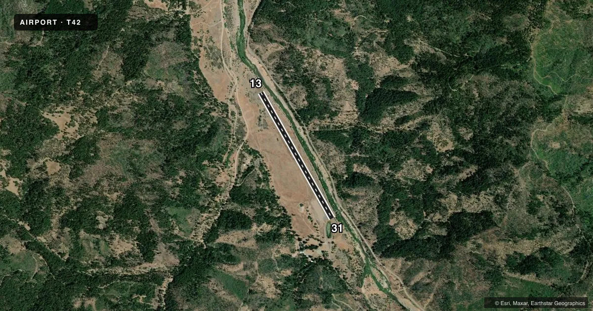
Runways & pattern
Full pagePattern entry · RWY 31
LEFT TRAFFICRunway end performance
| End | TORA | TODA | ASDA | LDA | VGSI | Approach lights | Obstruction |
|---|---|---|---|---|---|---|---|
| 13 | — | — | — | — | — | — | 6', berm, 200' from thr, 125' R of cntrln, slope 0 |
| 31 | — | — | — | — | — | — | 400', hill, 2400' from thr, 400' R of cntrln, slope 5 |
Declared distances in feet. TORA = takeoff run available, TODA = takeoff distance, ASDA = accelerate-stop, LDA = landing distance.
Airport sketch
Runways drawn to scale from FAA survey coordinates, rendered over satellite imagery. Not for navigation.
Approaches & charts
Services on the field
Fuel grades, oxygen, maintenance, ramp storage and lighting — as declared to the FAA by the airport operator.
Fuel & services
- Fuel
- Not available
- Oxygen (bottled)
- Not available
- Oxygen (bulk)
- Not available
- Airframe repair
- Not available
- Power plant repair
- Not available
Ramp & ground
- Transient storage
- Tie-down
- Landing fee
- No fee published
- Customs
- Not available
- Wind indicator
- Yes
- Segmented circle
- No
Fuel & FBOs
Cheapest 100LL and Jet A on the field and nearby. Always confirm with the FBO before taxi.
Airport notes
Surface conditions, obstructions, local procedures, lighting outages and other notes published with each FAA cycle.
General notes
- AIRPORT CLSD NIGHTS.
- INTERMITTENTLY CLOSED WINTERS DUE TO SNOW, CTC COUNTY TRANSPORTATION OFFICE FOR INFO 530-623-1365.
- HIGH TERRAIN ALL QUADRANTS.
- FOR CD CTC OAKLAND ARTCC AT 510-745-3380.
Approach & departure obstructions
- 134' FENCE 75' LEFT & 100' RIGHT OF CNTRLN.
Other notes
- MANAGERDIRECTOR OF TRANSPORTATION; OFFICE IN WEAVERVILLE.
- MANAGERTRINITY COUNTY TRANSPORTATION SERVICES OFFICE IN WEAVERVILLE
VFR map & nearby airports
VFR sectional. Tap any ICAO chip to open that airport.
Key facts · T42
Answer card- ICAO
- T42
- Name
- RUTH
- Location
- RUTH, CALIFORNIA
- Elevation
- 2,781 ft MSL
- Traffic pattern altitude
- 3,781 ft MSL (1,000 AGL)
- Control tower
- Non-towered (use CTAF)
- Total runways
- 1
- Longest runway
- 13/31 · 3,500 ft
- Published ILS approaches
- 0
- Published frequencies
- 2
- Magnetic variation
- 17°
- Current flight rules
- VFR
- Current wind
- 300° at 14 kt
- Favored runway now
- RWY 31
T42 sits in Ruth, California at 2,781 ft MSL. It has one runway. Runway 13/31 is 3,500 ft long with an asphalt surface. The field is non-towered. CTAF and UNICOM are both 122.8. No ILS approaches are published here.
Pattern altitude is not published. Use the standard 1,000 ft AGL for light piston traffic unless the current Chart Supplement says otherwise. That puts the pattern around 3,781 ft MSL based on the field elevation. The airport is closed at night. It is also intermittently closed in winter because of snow. Check before you launch.
There are no on-field FBOs listed. Plan to confirm services with the airport operator before arrival. Published remarks also note high terrain in all quadrants. That matters here. Expect a mountain airport profile with limited margin for weather, density altitude and terrain clearance. There is also a 4-foot fence near runway 13, offset left and right of the centerline. For clearance delivery, contact Oakland ARTCC. If you need current operating status, call the Trinity County Transportation Services office in Weaverville.