METAR & TAF O54
Current METAR
Observed 05:55Z
KO54 270555Z AUTO 19006KT 10SM CLR 24/06 A3005 RMK A01
- Wind
- 190° @ 6 kt
- Visibility
- 10 SM
- Temp / Dew
- 24°C / 6°C
- Altimeter
- 30.05 inHg
- Clouds
- CLR
- Density alt
- 3,833 ft
- Ceiling
- Unlimited
- Rules
- VFR
Airport info & contacts
Manager on record, flight service, ARTCC, attendance schedule and pattern altitude — published by the FAA and refreshed every 28 days.
Location
- From city
- 1 NM NE
- VFR sectional
- KLAMATH FALLS
- Pattern altitude
- 800 ft AGL · 3,150 ft MSL
- ARTCC
- ZOA · OAKLAND
- NOTAM facility
- RIU (NOTAM-D)
Airport manager
- Name
- PANOS KOKKAS
- Phone
- 530-623-1365
- Address
- PO BOX 2490, WEAVERVILLE CA 96093-2490
Flight service · Hours
- FSS RIU
- RANCHO MURIETA1-800-WX-BRIEF
- Attendance
- Unattended
Frequencies
Tap any row to copy the frequency to your clipboard.
Runways & pattern
Full pagePattern entry · RWY 18
LEFT TRAFFICRunway end performance
| End | TORA | TODA | ASDA | LDA | VGSI | Approach lights | Obstruction |
|---|---|---|---|---|---|---|---|
| 18 | — | — | — | — | — | — | 60', trees, 240' from thr, 0' R of cntrln, slope 0 |
| 36 | — | — | — | — | PAPI 2-box left(3°) | — | 10', road, 200' from thr, 220' R of cntrln, slope 0 |
Declared distances in feet. TORA = takeoff run available, TODA = takeoff distance, ASDA = accelerate-stop, LDA = landing distance.
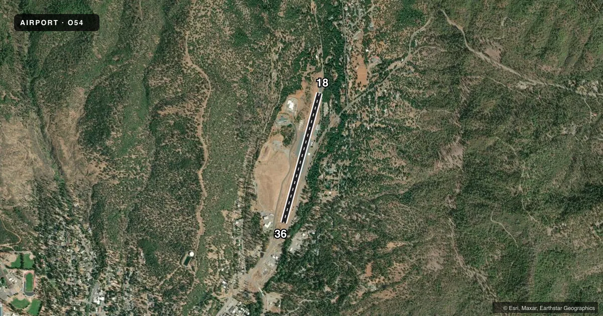
Airport sketch
Runways drawn to scale from FAA survey coordinates, rendered over satellite imagery. Not for navigation.
Approaches & charts
Services on the field
Fuel grades, oxygen, maintenance, ramp storage and lighting — as declared to the FAA by the airport operator.
Fuel & services
- Fuel
- Not available
- Oxygen (bottled)
- Not available
- Oxygen (bulk)
- Not available
Ramp & ground
- Transient storage
- Tie-down
- Landing fee
- No fee published
- Customs
- Not available
- Wind indicator
- Yes
- Segmented circle
- Yes
Fuel & FBOs
Cheapest 100LL and Jet A on the field and nearby. Always confirm with the FBO before taxi.
Airport notes
Surface conditions, obstructions, local procedures, lighting outages and other notes published with each FAA cycle.
General notes
- ROAD 50 FT E OF CNTRLN AT RY 18 THR & 60 FT TREES IN PRIMARY SFC 80 FT E OF RY CNTRLN.
- ARPT CLSD NIGHTS.
- LAND RWY 36 ONLY. TKOF RWY 18 ONLY. TOUCH & GO'S PROHIBITED. RECOMMEND NO GO-AROUNDS BELOW 2,600 FT MSL. TKOF PROHIBITED ON RWY 36 DUE TO RWY ELEV INCREASE OF APPX 100 FT ON NORTH END OF RWY. TALL TREES AND RISING TERRAIN NORTH OF ARPT. SIGNIFICANT VARIATIONS IN WIND DIRECTION AND INTST CAN OCCUR AT THE APCH TO RWY 36.
- ARPT INTERMITTENTLY CLOSED WINTERS DUE TO SNOW. CALL COUNTY TRANSPORTATION OFFICE FOR INFO 530-623-1365.
Approach & departure obstructions
- 18+15 FT ROAD 0 FT FROM RY END 60 FT LEFT.
- 36HWY 5-10 FT BELOW RY THR; 0-200 FT FROM RY THR 125 FT RIGHT TO 25 FT RIGHT.
- 36RWY 36 APCH RATIO 30:1 FM DSPLCD THLD; APCH RATIO 20:1 OVER 45 FT TREE 935 FT FM DSPLCD THLD 230 FT RIGHT.
Other notes
- ESTABD PRIOR TO 15 MAY 1959.
- MANAGERDIRECTOR OF TRANSPORTATION
VFR map & nearby airports
VFR sectional. Tap any ICAO chip to open that airport.
Key facts · O54
Answer card- ICAO
- O54
- Name
- LONNIE POOL FLD/WEAVERVILLE
- Location
- WEAVERVILLE, CALIFORNIA
- Elevation
- 2,350 ft MSL
- Traffic pattern altitude
- 3,150 ft MSL (800 AGL)
- Control tower
- Non-towered (use CTAF)
- Total runways
- 1
- Longest runway
- 18/36 · 3,181 ft
- Published ILS approaches
- 0
- Published frequencies
- 2
- Magnetic variation
- 17°
- Current flight rules
- VFR
- Current wind
- 190° at 6 kt
- Favored runway now
- RWY 18
Lonnie Pool Fld/Weaverville (O54) is in Weaverville, California. Field elevation is 2,350 ft MSL. The airport has one runway, 18/36. The longest runway is 3,181 ft asphalt. There is no control tower. CTAF and UNICOM are both 122.8.
Pattern altitude is 800 ft AGL, which is 3,150 ft MSL. No ILS approaches are published. The published remarks matter here. Land on runway 36 only. Takeoff is on runway 18 only. Touch-and-go operations are prohibited. No go-arounds are recommended below 2,600 ft MSL. The airport is closed at night. It is also intermittently closed in winter because of snow. Call the County Transportation Office before you go if conditions are questionable.
This is a mountain field with terrain and trees close in. Tall trees and rising terrain are north of the airport. The runway 36 approach has a displaced-threshold clearance issue with a highway near the threshold and a tree on final. Runway 18 has a road near the departure end. There are no on-field FBOs listed. Verify services with the airport operator or call the field directly before arrival. For a first-time pilot, plan a conservative approach. Expect wind shifts. Review the current Chart Supplement before flying in.