METAR & TAF O21
O21 does not publish a METAR.
Showing the nearest reporting station: KACV (CALIFORNIA REDWOOD COAST-HUMBOLDT COUNTY) · 20.3 NM away. Conditions at O21 may differ.
METAR · KACV
Observed 10:53Z
KACV 271053Z AUTO 33003KT 10SM OVC011 14/12 A3008 RMK AO2 SLP191 T01390122
- Wind
- 330° @ 3 kt
- Visibility
- 10 SM
- Temp / Dew
- 14°C / 12°C
- Altimeter
- 30.08 inHg
- Clouds
- OVC
- Density alt
- 123 ft
- Ceiling
- 1,100 ft AGL
- Rules
- MVFR
Airport info & contacts
Manager on record, flight service, ARTCC, attendance schedule and pattern altitude — published by the FAA and refreshed every 28 days.
Location
- From city
- 1 NM SE
- VFR sectional
- KLAMATH FALLS
- Pattern altitude
- 800 ft AGL · 1,156 ft MSL
- ARTCC
- ZSE · SEATTLE
- NOTAM facility
- OAK (NOTAM-D)
Airport manager
- Name
- MR. JEFF HODGE
- Phone
- (707) 601-8035
- Address
- P.O. BOX 789, HOOPA CA 95546
Flight service · Hours
- FSS OAK
- OAKLAND1-800-WX-BRIEF
- Attendance
- Unattended
Frequencies
Tap any row to copy the frequency to your clipboard.
Runways & pattern
Full pagePattern entry · RWY 32
RIGHT TRAFFICRunway end performance
| End | TORA | TODA | ASDA | LDA | VGSI | Approach lights | Obstruction |
|---|---|---|---|---|---|---|---|
| 14 | — | — | — | — | — | — | 15', trees, 201' from thr, 30' R of cntrln, slope 1 |
| 32 | — | — | — | — | — | — | 147', trees, 3000' from thr, 0' R of cntrln, slope 19 |
Declared distances in feet. TORA = takeoff run available, TODA = takeoff distance, ASDA = accelerate-stop, LDA = landing distance.
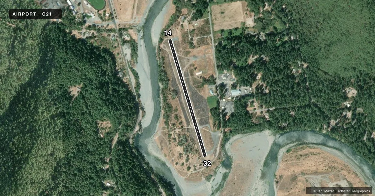
Airport sketch
Runways drawn to scale from FAA survey coordinates, rendered over satellite imagery. Not for navigation.
Approaches & charts
Services on the field
Fuel grades, oxygen, maintenance, ramp storage and lighting — as declared to the FAA by the airport operator.
Fuel & services
- Fuel
- Not available
- Oxygen (bottled)
- Not available
- Oxygen (bulk)
- Not available
- Airframe repair
- Not available
- Power plant repair
- Not available
Ramp & ground
- Transient storage
- Tie-down
- Landing fee
- No fee published
- Customs
- Not available
- Wind indicator
- Yes
- Segmented circle
- Yes
Fuel & FBOs
Cheapest 100LL and Jet A on the field and nearby. Always confirm with the FBO before taxi.
Airport notes
Surface conditions, obstructions, local procedures, lighting outages and other notes published with each FAA cycle.
General notes
- DAY USE ONLY; CLSD NGTS.
- FOR CD CTC SEATTLE ARTCC AT 253-351-3694.
Approach & departure obstructions
- 14RWY 14 HAS 15 FT BRUSH AND TREES 90 FT R.
- 14RY 14 APCH SLOPE 18:1 TO DSPLCD THLD.
- 32RY 32 APCH SLOPE 20:1 TO DSPLCD THLD.
Other notes
- HAD INFORMAL APPROVAL UNDER TENTATIVE FAAP.
- WIND INDICATOR OBSCURED BY TREES.
- MANAGERHOOPA ROADS DEPT.
VFR map & nearby airports
VFR sectional. Tap any ICAO chip to open that airport.
Key facts · O21
Answer card- ICAO
- O21
- Name
- HOOPA
- Location
- HOOPA, CALIFORNIA
- Elevation
- 356 ft MSL
- Traffic pattern altitude
- 1,156 ft MSL (800 AGL)
- Control tower
- Non-towered (use CTAF)
- Total runways
- 1
- Longest runway
- 14/32 · 2,325 ft
- Published ILS approaches
- 0
- Published frequencies
- 1
- Magnetic variation
- 17°
- Current flight rules
- MVFR
- Current wind
- 330° at 3 kt
- Favored runway now
- RWY 32
Hoopa Airport sits in Hoopa, California. Field elevation is 356 ft MSL. The airport has one runway. Runway 14/32 is 2,325 ft long with an asphalt surface. There is no control tower. CTAF is 122.9. No ILS approaches are published here.
Pattern altitude is 800 ft AGL, which is 1,156 ft MSL. That matters here because the field is in a valley setting with nearby terrain and trees affecting the approach picture. Published remarks also call out brush and trees 90 feet right of Runway 14. The Runway 14 approach slope is steep to the displaced threshold. Runway 32 also has a steep approach slope to its displaced threshold. The wind indicator is obscured by trees, so plan to verify winds before you commit.
This is a day-use airport only. It is closed at night. For clearance delivery, contact Seattle ARTCC at 253-351-3694. No on-field FBOs are listed, so contact the airport operator directly before arrival if you need local support. The manager is the Hoopa Roads Department. If you are planning a first visit, treat this as a short-field, no-frills stop with limited published approach support. Check the current FAA Chart Supplement for any updates before you go.