METAR & TAF O85
O85 does not publish a METAR.
Showing the nearest reporting station: KRDD (REDDING RGNL) · 6.5 NM away. Conditions at O85 may differ.
METAR · KRDD
Observed 06:53Z
KRDD 270653Z AUTO 36005KT 10SM CLR 26/08 A2991 RMK AO2 SLP121 T02610083 403720178 $
- Wind
- 360° @ 5 kt
- Visibility
- 10 SM
- Temp / Dew
- 26°C / 8°C
- Altimeter
- 29.91 inHg
- Clouds
- CLR
- Density alt
- 2,229 ft
- Ceiling
- Unlimited
- Rules
- VFR
Airport info & contacts
Manager on record, flight service, ARTCC, attendance schedule and pattern altitude — published by the FAA and refreshed every 28 days.
Location
- From city
- 1 NM W
- VFR sectional
- KLAMATH FALLS
- ARTCC
- ZOA · OAKLAND
- NOTAM facility
- RIU (NOTAM-D)
Airport manager
- Name
- ANDREW SOLSVIG
- Phone
- 530-224-4321
- Address
- 6751 WOODRUM CIRCLE, #200, REDDING CA 96002
Flight service · Hours
- FSS RIU
- RANCHO MURIETA1-800-WX-BRIEF
- Attendance
- 0700-1700
Frequencies
Tap any row to copy the frequency to your clipboard.
Runways & pattern
Full pagePattern entry · RWY 34
LEFT TRAFFICRunway end performance
| End | TORA | TODA | ASDA | LDA | VGSI | Approach lights | Obstruction |
|---|---|---|---|---|---|---|---|
| 16 | — | — | — | — | PAPI 2-box left(3.5°) | — | — |
| 34 | — | — | — | — | PAPI 2-box left(3.5°) | — | — |
Declared distances in feet. TORA = takeoff run available, TODA = takeoff distance, ASDA = accelerate-stop, LDA = landing distance.
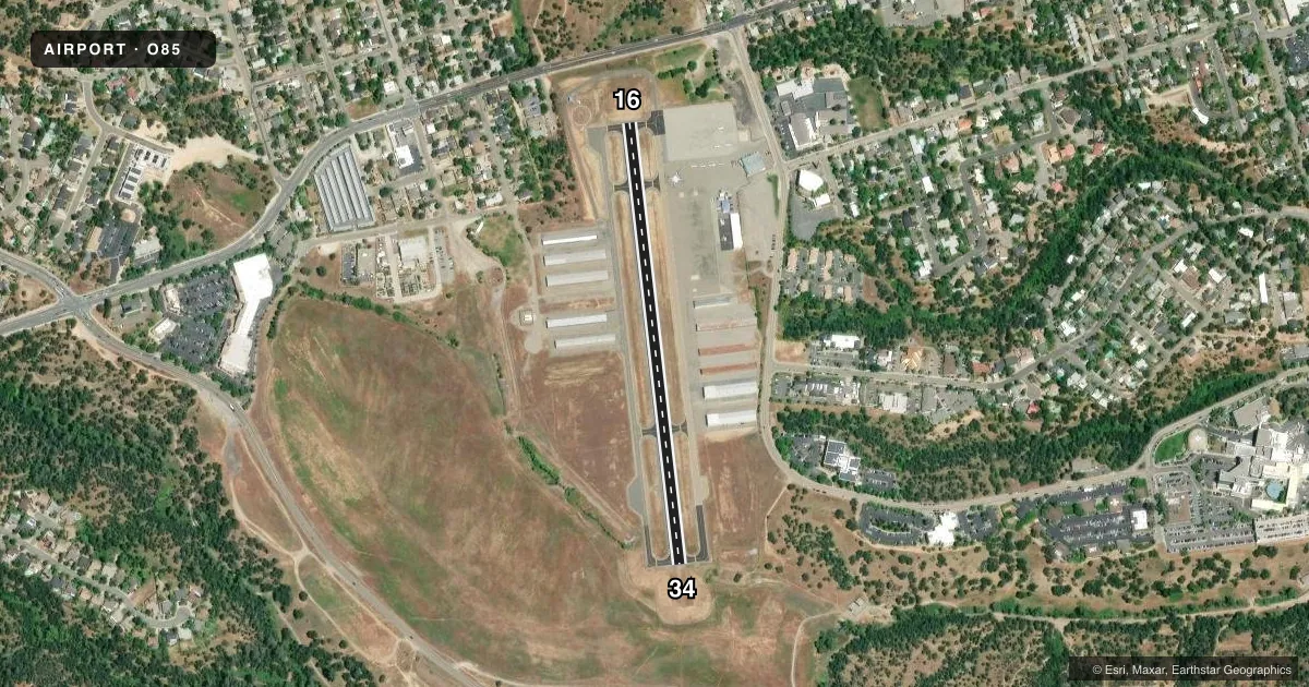
Airport sketch
Runways drawn to scale from FAA survey coordinates, rendered over satellite imagery. Not for navigation.
Approaches & charts
Services on the field
Fuel grades, oxygen, maintenance, ramp storage and lighting — as declared to the FAA by the airport operator.
Fuel & services
- Fuel
- 100LLA
- Oxygen (bottled)
- HIGH/LOW
- Oxygen (bulk)
- HIGH/LOW
- Airframe repair
- Major
- Power plant repair
- Major
- Other services
- AVNCS,CHTR,INSTR,RNTL,SALES
Ramp & ground
- Transient storage
- Tie-down
- Landing fee
- No fee published
- Customs
- Not available
- Lighting schedule
- SEE RMK
- Beacon schedule
- SS-SR
- Beacon
- White / Green (civil land)(WG)
- Wind indicator
- Lighted
- Segmented circle
- Yes
Fuel & FBOs
Cheapest 100LL and Jet A on the field and nearby. Always confirm with the FBO before taxi.
Airport notes
Surface conditions, obstructions, local procedures, lighting outages and other notes published with each FAA cycle.
General notes
- LARGE BIRDS FREQUENTLY ON AND IN VICINITY OF ARPT OCT-APR.
- RWY 16/34 HALFWAY DIST MARKERS BOTH SIDES OF RWY.
- FOR NOISE ABATEMENT CLIMB TO 1500 FT AGL BFR TURNING. CALM WIND PREFERRED DRCTN IS RWY 34.
- FOR CD CTC OAKLAND ARTCC AT 510-745-3380.
Lighting notes
- ACTVT PAPI RWY 16 & 34; MIRL RWY 16/34 - CTAF.
Other notes
- ESTABD PRIOR TO 15 MAY 1959.
- 1AFTER HOURS CTC 530-319-3031.
- MANAGERPHONE MGRS OFFICE AT RDD (530) 224-4321.
VFR map & nearby airports
VFR sectional. Tap any ICAO chip to open that airport.
Key facts · O85
Answer card- ICAO
- O85
- Name
- BENTON FLD
- Location
- REDDING, CALIFORNIA
- Elevation
- 723.2 ft MSL
- Traffic pattern altitude
- 1,723.2 ft MSL (1,000 AGL)
- Control tower
- Non-towered (use CTAF)
- Total runways
- 1
- Longest runway
- 16/34 · 2,420 ft
- Published ILS approaches
- 0
- Published frequencies
- 2
- Magnetic variation
- 14°
- Current flight rules
- VFR
- Current wind
- 360° at 5 kt
- Favored runway now
- RWY 34
Benton Fld (O85) sits in Redding, California at 723.2 ft MSL. It has one runway, 16/34, which is 2,420 ft long and asphalt. There is no control tower. CTAF and UNICOM are both 122.8. No ILS approaches are published here, so plan with the current chart and weather in mind.
The published pattern altitude is not listed. Use the standard 1,000 ft AGL pattern unless the current FAA Chart Supplement says otherwise. The field is a small, non-towered airport with a single short runway, so performance planning matters. Runway 34 is the calm-wind preferred direction. Noise abatement calls for a climb to 1,500 ft AGL before turning. Large birds are reported on and near the airport from October through April, so keep a sharp scan on departure and arrival.
Cardan Aircraft Services is on the field. It carries 100LL and Jet A. After hours contact is 530-319-3031. The runway has PAPI on 16 and 34. Medium intensity runway lights are CTAF-activated. Halfway distance markers are also published on both sides of the runway. For clearance delivery, contact Oakland ARTCC at 510-745-3380.