METAR & TAF 0O4
0O4 does not publish a METAR.
Showing the nearest reporting station: KRBL (RED BLUFF MUNI) · 12.8 NM away. Conditions at 0O4 may differ.
METAR · KRBL
Observed 15:54Z
KRBL 251554Z AUTO 16006KT 10SM CLR 23/12 A2997 RMK AO2 SLP146 T02280117
- Wind
- 160° @ 6 kt
- Visibility
- 10 SM
- Temp / Dew
- 23°C / 12°C
- Altimeter
- 29.97 inHg
- Clouds
- CLR
- Density alt
- 1,264 ft
- Ceiling
- Unlimited
- Rules
- VFR
Airport info & contacts
Manager on record, flight service, ARTCC, attendance schedule and pattern altitude — published by the FAA and refreshed every 28 days.
Location
- From city
- 1 NM NE
- VFR sectional
- SAN FRANCISCO
- ARTCC
- ZOA · OAKLAND
- NOTAM facility
- RIU (NOTAM-D)
Airport manager
- Name
- ELIJAH STANLEY
- Phone
- 530-824-7025
- Address
- 794 3RD STREET, CORNING CA 96021
Flight service · Hours
- FSS RIU
- RANCHO MURIETA1-800-WX-BRIEF
- Attendance
- 0800-1700
Frequencies
Tap any row to copy the frequency to your clipboard.
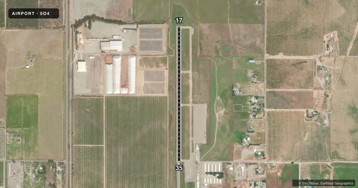
Runways & pattern
Full pagePattern entry · RWY 17
LEFT TRAFFICAirport sketch
Runways drawn to scale from FAA survey coordinates, rendered over satellite imagery. Not for navigation.
Approaches & charts
Services on the field
Fuel grades, oxygen, maintenance, ramp storage and lighting — as declared to the FAA by the airport operator.
Fuel & services
- Fuel
- Not available
- Oxygen (bottled)
- HIGH/LOW
- Airframe repair
- Major
- Power plant repair
- Major
- Other services
- INSTR,RNTL
Ramp & ground
- Transient storage
- Tie-down
- Landing fee
- No fee published
- Customs
- Not available
- Lighting schedule
- SEE RMK
- Beacon schedule
- SS-SR
- Beacon
- White / Green (civil land)(WG)
- Wind indicator
- Lighted
- Segmented circle
- Yes
Fuel & FBOs
Cheapest 100LL and Jet A on the field and nearby. Always confirm with the FBO before taxi.
Airport notes
Surface conditions, obstructions, local procedures, lighting outages and other notes published with each FAA cycle.
General notes
- ULTRALIGHT ACTIVITY ON & INVOF ARPT.
- MEDICAL/FIREFIGHTING/AGRICULTURAL HELICOPTERS IN VCNTY APRT.
- APRT RSTD TO ACFT LESS THAN 12,500 LBS MAX TAKEOFF WEIGHT OR LESS.
- FOR CD CTC OAKLAND ARTCC AT 510-745-3380.
Lighting notes
- ACTVT MIRL RY 17/35 - CTAF.
Runway surface & condition
- 17/35300 FT STOPWAY NORTH END OF RY; 200 FT STOPWAY SOUTH END OF RY.
Other notes
- 1FBO ON ARPT PHONE 530-586-8566.
VFR map & nearby airports
VFR sectional. Tap any ICAO chip to open that airport.
Key facts · 0O4
Answer card- ICAO
- 0O4
- Name
- CORNING MUNI
- Location
- CORNING, CALIFORNIA
- Elevation
- 295.4 ft MSL
- Traffic pattern altitude
- 1,295.4 ft MSL (1,000 AGL)
- Control tower
- Non-towered (use CTAF)
- Total runways
- 1
- Longest runway
- 17/35 · 2,699 ft
- Published ILS approaches
- 0
- Published frequencies
- 2
- Magnetic variation
- 17°
- Current flight rules
- VFR
- Current wind
- 160° at 6 kt
- Favored runway now
- RWY 17
Corning Muni is in Corning, California. The field elevation is 295.4 ft MSL. It has one runway, 17/35, which is 2,699 ft long. There is no control tower. CTAF and UNICOM are both 123.0. No ILS approaches are published here.
Pattern altitude is not published. Use 1,000 ft AGL for light piston operations unless the current FAA Chart Supplement says otherwise. The airport is restricted to aircraft with a maximum takeoff weight of less than 12,500 pounds. That matters if you are planning to bring in a heavier airplane.
The runway has medium intensity lighting. It is activated by using the common traffic advisory frequency. The north end has a 300 ft stopway. The south end has a 200 ft stopway. Ultralight activity occurs on and near the airport. Medical, firefighting and agricultural helicopters also operate in the vicinity. If you are new to the field, keep a sharp scan in the pattern and on short final.
A fixed base operator is on the airport. The published remark gives a phone number for the FBO at 530-586-8566. The remarks do not list fuel grades. Verify current fuel availability with the FBO directly before arrival. For clearance delivery, contact Oakland ARTCC at 510-745-3380.