METAR & TAF O05
Current METAR
Observed 09:15Z
KO05 270915Z AUTO 30003KT 10SM FEW040 11/M01 A3018 RMK A01
- Wind
- 300° @ 3 kt
- Visibility
- 10 SM
- Temp / Dew
- 11°C / -1°C
- Altimeter
- 30.18 inHg
- Clouds
- FEW
- Density alt
- 4,820 ft
- Ceiling
- Unlimited
- Rules
- VFR
Airport info & contacts
Manager on record, flight service, ARTCC, attendance schedule and pattern altitude — published by the FAA and refreshed every 28 days.
Location
- From city
- 2 NM SW
- VFR sectional
- KLAMATH FALLS
- ARTCC
- ZOA · OAKLAND
- NOTAM facility
- RIU (NOTAM-D)
Airport manager
- Name
- NICK COLLIN
- Phone
- 530-283-6069
- Address
- 198 ANDY'S WAY, QUINCY CA 95971-7007
Flight service · Hours
- FSS RIU
- RANCHO MURIETA1-800-WX-BRIEF
- Attendance
- 0800-DUSK
Frequencies
Tap any row to copy the frequency to your clipboard.
Runways & pattern
Full pagePattern entry · RWY 34
RIGHT TRAFFICRunway end performance
| End | TORA | TODA | ASDA | LDA | VGSI | Approach lights | Obstruction |
|---|---|---|---|---|---|---|---|
| 16 | — | — | — | — | PAPI 2-box left(3°) | — | 50', trees, 1200' from thr, 375' R of cntrln, slope 20 |
| 34 | — | — | — | — | PAPI 2-box left(3°) | — | 67', trees, 2500' from thr, 350' R of cntrln, slope 34 |
Declared distances in feet. TORA = takeoff run available, TODA = takeoff distance, ASDA = accelerate-stop, LDA = landing distance.
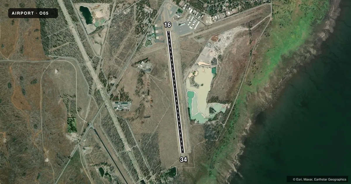
Airport sketch
Runways drawn to scale from FAA survey coordinates, rendered over satellite imagery. Not for navigation.
Approaches & charts
Services on the field
Fuel grades, oxygen, maintenance, ramp storage and lighting — as declared to the FAA by the airport operator.
Fuel & services
- Fuel
- 100LLA
- Oxygen (bottled)
- Not available
- Oxygen (bulk)
- Not available
- Airframe repair
- Not available
- Power plant repair
- Not available
- Other services
- CHTR,INSTR
Ramp & ground
- Transient storage
- Tie-down
- Landing fee
- No fee published
- Customs
- Not available
- Lighting schedule
- SEE RMK
- Beacon schedule
- SS-SR
- Beacon
- White / Green (civil land)(WG)
- Wind indicator
- Lighted
- Segmented circle
- Yes
Fuel & FBOs
Cheapest 100LL and Jet A on the field and nearby. Always confirm with the FBO before taxi.
Airport notes
Surface conditions, obstructions, local procedures, lighting outages and other notes published with each FAA cycle.
General notes
- (E93) TWO 40' DIAMETER CONC HELIPADS /USFS/ ON FLD.
- FOR CD CTC OAKLAND ARTCC AT 510-745-3380.
Lighting notes
- ACTVT MIRL RY 16/34 & PAPI RYS 16 & 34 - CTAF.
Runway surface & condition
- 16/34ESTIMATED BY OWNER.
Other notes
- ESTABD PRIOR TO 15 MAY 1959.
- PLUS SEVERAL FIRE BOMBERS DURING SUMMER.
- MANAGERAIRPORT FBO PHONE 530-258-3616.
VFR map & nearby airports
VFR sectional. Tap any ICAO chip to open that airport.
Key facts · O05
Answer card- ICAO
- O05
- Name
- ROGERS FLD
- Location
- CHESTER, CALIFORNIA
- Elevation
- 4,534.4 ft MSL
- Traffic pattern altitude
- 5,534.4 ft MSL (1,000 AGL)
- Control tower
- Non-towered (use CTAF)
- Total runways
- 1
- Longest runway
- 16/34 · 5,020 ft
- Published ILS approaches
- 0
- Published frequencies
- 2
- Magnetic variation
- 13°
- Current flight rules
- VFR
- Current wind
- 300° at 3 kt
- Favored runway now
- RWY 34
Rogers Field sits in Chester, California at 4,534.4 ft MSL. It has one runway, 16/34, which is 5,020 ft of asphalt. There is no control tower. CTAF and UNICOM are both 122.8. No ILS approaches are published here. Pattern altitude is not published, so use 1,000 ft AGL for light piston operations unless the current Chart Supplement says otherwise.
The on-field FBO is Rogers Field. It carries 100LL and Jet A. The FBO phone is (530) 258-3616. Published remarks note that the airport was established before 15 May 1959. Summer traffic can include several fire bombers. That matters if you are arriving during fire season.
Runway lights on 16/34 are medium intensity and are activated by CTAF. The precision approach path indicators on both ends are also controlled by CTAF. There are two 40-foot concrete helipads on the field for US Forest Service use. For clearance delivery, contact Oakland ARTCC at 510-745-3380.
At this elevation, performance planning matters. Expect high-density-altitude effects on takeoff and climb. Chester is in a mountain setting, so review terrain, density altitude and the current Chart Supplement before departure. If you need noise or curfew details, verify them with the current Chart Supplement or the airport operator.