METAR & TAF O89
O89 does not publish a METAR.
Showing the nearest reporting station: KAAT (ALTURAS MUNI) · 48.2 NM away. Conditions at O89 may differ.
METAR · KAAT
Observed 09:55Z
KAAT 270955Z AUTO 00000KT 10SM CLR 10/M01 A3016 RMK AO2 SLP170 T01001011 $
- Wind
- 000° @ 0 kt
- Visibility
- 10 SM
- Temp / Dew
- 10°C / -1°C
- Altimeter
- 30.16 inHg
- Clouds
- CLR
- Density alt
- 3,229 ft
- Ceiling
- Unlimited
- Rules
- VFR
Airport info & contacts
Manager on record, flight service, ARTCC, attendance schedule and pattern altitude — published by the FAA and refreshed every 28 days.
Location
- From city
- 1 NM N
- VFR sectional
- KLAMATH FALLS
- Pattern altitude
- 800 ft AGL · 4,128 ft MSL
- ARTCC
- ZOA · OAKLAND
- NOTAM facility
- RIU (NOTAM-D)
Airport manager
- Name
- SHANE WINTON
- Phone
- 530-225-5090
- Address
- 1855 PLACER STREET, REDDING CA 96001
Flight service · Hours
- FSS RIU
- RANCHO MURIETA1-800-WX-BRIEF
- Attendance
- UNATNND
Frequencies
Tap any row to copy the frequency to your clipboard.
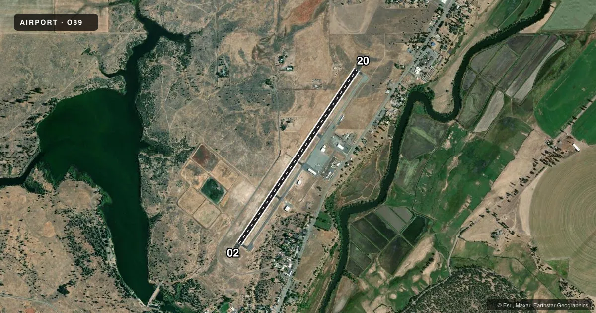
Runways & pattern
Full pagePattern entry · RWY 02
LEFT TRAFFICAirport sketch
Runways drawn to scale from FAA survey coordinates, rendered over satellite imagery. Not for navigation.
Approaches & charts
Services on the field
Fuel grades, oxygen, maintenance, ramp storage and lighting — as declared to the FAA by the airport operator.
Fuel & services
- Fuel
- Not available
- Oxygen (bottled)
- Not available
- Oxygen (bulk)
- Not available
- Airframe repair
- Not available
- Power plant repair
- Not available
Ramp & ground
- Transient storage
- Tie-down
- Landing fee
- No fee published
- Customs
- Not available
- Lighting schedule
- SEE RMK
- Beacon schedule
- SS-SR
- Beacon
- White / Green (civil land)(WG)
- Wind indicator
- Lighted
- Segmented circle
- Yes
Fuel & FBOs
Cheapest 100LL and Jet A on the field and nearby. Always confirm with the FBO before taxi.
Airport notes
Surface conditions, obstructions, local procedures, lighting outages and other notes published with each FAA cycle.
General notes
- CROP DUSTERS WORKING INVOF ARPT FEB-OCT.
- ARPT CLSD PERIODICALLY WINTER MONTHS DUE TO SNOW, CALL AMGR (530) 225-5661 FOR CURRENT CONDITIONS.
- FOR CD CTC OAKLAND ARTCC AT 510-745-3380.
Lighting notes
- ACTVT MIRL RY 02/20 - CTAF.
Runway surface & condition
- 02/20GROSS WEIGHT STRENGTH PRVDD BY ARPT MANAGEMENT 12500 LBS.
Other notes
- ESTABD PRIOR TO 15 MAY 1959.
- MANAGERSWINTON@SHASTACOUNTY.GOV
VFR map & nearby airports
VFR sectional. Tap any ICAO chip to open that airport.
Key facts · O89
Answer card- ICAO
- O89
- Name
- FALL RIVER MILLS
- Location
- FALL RIVER MILLS, CALIFORNIA
- Elevation
- 3,328 ft MSL
- Traffic pattern altitude
- 4,128 ft MSL (800 AGL)
- Control tower
- Non-towered (use CTAF)
- Total runways
- 1
- Longest runway
- 02/20 · 5,000 ft
- Published ILS approaches
- 0
- Published frequencies
- 2
- Magnetic variation
- 17°
- Current flight rules
- VFR
- Current wind
- 000° at 0 kt
- Favored runway now
- –
Fall River Mills Airport (O89) sits in Fall River Mills, California. The field elevation is 3,328 ft MSL. It has one runway. Runway 02/20 is 5,000 ft long with an asphalt surface. The airport is not towered. CTAF and UNICOM are both 122.8. Pattern altitude is 800 ft AGL, which puts the traffic pattern at 4,128 ft MSL.
There are no published ILS approaches here. The runway lights on 02/20 are medium intensity lights that activate by CTAF. The airport manager can be reached at swinton@shastacounty.gov. The airport is closed periodically during winter months because of snow. Call the airport manager at (530) 225-5661 for current conditions before you launch.
A first-time pilot should plan for a high-elevation field with winter weather impacts. Crop dusters also work in the area from February through October, so keep a sharp scan in the pattern and on departure. The published gross weight strength for 02/20 is 12,500 pounds. Oakland ARTCC handles clearance delivery. If you need current operational details, check the current FAA Chart Supplement or call the airport manager directly.