METAR & TAF A24
A24 does not publish a METAR.
Showing the nearest reporting station: KAAT (ALTURAS MUNI) · 6.8 NM away. Conditions at A24 may differ.
METAR · KAAT
Observed 12:55Z
KAAT 271255Z AUTO 00000KT 10SM CLR 06/M02 A3017 RMK AO2 SLP180 T00611017 $
- Wind
- 000° @ 0 kt
- Visibility
- 10 SM
- Temp / Dew
- 6°C / -2°C
- Altimeter
- 30.17 inHg
- Clouds
- CLR
- Density alt
- 4,052 ft
- Ceiling
- Unlimited
- Rules
- VFR
Airport info & contacts
Manager on record, flight service, ARTCC, attendance schedule and pattern altitude — published by the FAA and refreshed every 28 days.
Location
- From city
- 8 NM SW
- VFR sectional
- KLAMATH FALLS
- Pattern altitude
- 800 ft AGL · 5,189 ft MSL
- ARTCC
- ZSE · SEATTLE
- NOTAM facility
- RNO (NOTAM-D)
Airport manager
- Name
- RYAN SHERER
- Phone
- 530-233-2766
- Address
- HCR 4, BOX 43002, ALTURAS CA 96101
Flight service · Hours
- FSS RNO
- RENO1-800-WX-BRIEF
- Attendance
- Unattended
Frequencies
Tap any row to copy the frequency to your clipboard.
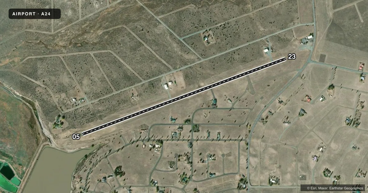
Runways & pattern
Full pagePattern entry · RWY 05
LEFT TRAFFICAirport sketch
Runways drawn to scale from FAA survey coordinates, rendered over satellite imagery. Not for navigation.
Approaches & charts
Services on the field
Fuel grades, oxygen, maintenance, ramp storage and lighting — as declared to the FAA by the airport operator.
Fuel & services
- Fuel
- Not available
Ramp & ground
- Transient storage
- Tie-down
- Wind indicator
- Yes
- Segmented circle
- Yes
Fuel & FBOs
Cheapest 100LL and Jet A on the field and nearby. Always confirm with the FBO before taxi.
Airport notes
Surface conditions, obstructions, local procedures, lighting outages and other notes published with each FAA cycle.
General notes
- VEHICLES OPERATING INVOF ARPT.
- DEER INVOF ARPT.
- FOR CD CTC SEATTLE ARTCC AT 253-351-3694.
Other notes
- VFR ONLY.
- MANAGERCAL PINES SER DIST
VFR map & nearby airports
VFR sectional. Tap any ICAO chip to open that airport.
Key facts · A24
Answer card- ICAO
- A24
- Name
- CALIFORNIA PINES
- Location
- ALTURAS, CALIFORNIA
- Elevation
- 4,389 ft MSL
- Traffic pattern altitude
- 5,189 ft MSL (800 AGL)
- Control tower
- Non-towered (use CTAF)
- Total runways
- 1
- Longest runway
- 05/23 · 4,159 ft
- Published ILS approaches
- 0
- Published frequencies
- 2
- Magnetic variation
- 17°
- Current flight rules
- VFR
- Current wind
- 000° at 0 kt
- Favored runway now
- –
California Pines Airport (A24) is in Alturas, California. The field elevation is 4,389 ft MSL. It has one runway, 05/23, which is 4,159 ft long. There is no control tower. CTAF and UNICOM are both 123.0.
Pattern altitude is 800 ft AGL, which puts the pattern at 5,189 ft MSL. No ILS approaches are published. This is a VFR-only field, so plan accordingly and check the current FAA Chart Supplement before you go if you need any additional approach or operating details.
The published remarks call out deer in the vicinity of the airport. Vehicles also operate near the airport, so keep a sharp scan on taxi and runway movements. For clearance delivery, contact Seattle ARTCC at 253-351-3694. The airport is managed by Cal Pines Service District. There are no on-field FBOs listed in the facts, so verify services with the airport operator directly or call the field on CTAF/UNICOM before arrival. At 4,389 ft MSL, density altitude can matter, especially on warm days. Expect performance to be a factor on departure and landing.