METAR & TAF KLKV
Current METAR
Observed 12:53Z
KLKV 271253Z AUTO 34005KT 10SM CLR 06/00 A3018 RMK AO2 SLP188 T00610000
- Wind
- 340° @ 5 kt
- Visibility
- 10 SM
- Temp / Dew
- 6°C / 0°C
- Altimeter
- 30.18 inHg
- Clouds
- CLR
- Density alt
- 4,468 ft
- Ceiling
- Unlimited
- Rules
- VFR
Airport info & contacts
Manager on record, flight service, ARTCC, attendance schedule and pattern altitude — published by the FAA and refreshed every 28 days.
Location
- From city
- 3 NM SW
- VFR sectional
- KLAMATH FALLS
- ARTCC
- ZSE · SEATTLE
- NOTAM facility
- LKV (NOTAM-D)
Airport manager
- Name
- TRISTAN WITHAM
- Phone
- 541-947-4222
- Address
- 17819 AIRPORT ROAD, LAKE VIEW OR 97630
Flight service · Hours
- FSS MMV
- MC MINNVILLE1-800-WX-BRIEF
- Attendance
- APR-SEP · 0900-1600
- OCT-MAR · 0700-1700
Frequencies
Tap any row to copy the frequency to your clipboard.
Runways & pattern
Full pagePattern entry · RWY 35
LEFT TRAFFICRunway end performance
| End | TORA | TODA | ASDA | LDA | VGSI | Approach lights | Obstruction |
|---|---|---|---|---|---|---|---|
| 17 | — | — | — | — | PAPI 4-box right(3°) | — | — |
| 35 | — | — | — | — | PAPI 4-box left(3°) | — | — |
Declared distances in feet. TORA = takeoff run available, TODA = takeoff distance, ASDA = accelerate-stop, LDA = landing distance.
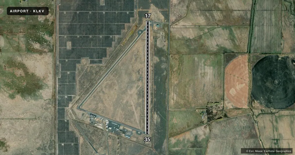
Airport sketch
Runways drawn to scale from FAA survey coordinates, rendered over satellite imagery. Not for navigation.
Approaches & charts
Services on the field
Fuel grades, oxygen, maintenance, ramp storage and lighting — as declared to the FAA by the airport operator.
Fuel & services
- Fuel
- 100LLA
- Oxygen (bottled)
- Not available
- Oxygen (bulk)
- Not available
- Airframe repair
- Major
- Power plant repair
- Major
Ramp & ground
- Transient storage
- Tie-down
- Landing fee
- No fee published
- Customs
- Not available
- Lighting schedule
- SEE RMK
- Beacon schedule
- SS-SR
- Beacon
- White / Green (civil land)(WG)
- Wind indicator
- Lighted
- Segmented circle
- Yes
Fuel & FBOs
Cheapest 100LL and Jet A on the field and nearby. Always confirm with the FBO before taxi.
Airport notes
Surface conditions, obstructions, local procedures, lighting outages and other notes published with each FAA cycle.
General notes
- FLOCKS OF LARGE WATERFOWL IN VICINITY NOV-MAY.
- EXTENSIVE AIRTANKER OPNS IN FIRE SEASON.
- DRAG STRIP ORIENTED NW-SE LOCATED 3000 FT SW OF RY 35.
- POSSIBLE GLIDER OPERATIONS ON TWY.
- TWY NE/SW USED FOR STRONG CROSS WIND LNDG.
- WILDLIFE ON AND INVOF ARPT.
- FOR CD IF UNA TO CTC ON FSS FREQ, CTC SEATTLE ARTCC AT 253-351-3694.
- COLD TEMPERATURE AIRPORT. ALTITUDE CORRECTION REQUIRED AT OR BELOW -26C.
Lighting notes
- ACTVT MIRL RWY 17/35, PAPI 17 & 35; REIL RWY 17 & 35 - CTAF.
Other notes
- ESTABLISHED PRIOR TO 1959.
- TETRAHEDRON LIGHTING INOPERATIVE.
VFR map & nearby airports
VFR sectional. Tap any ICAO chip to open that airport.
Key facts · KLKV
Answer card- ICAO
- KLKV
- Name
- LAKE COUNTY
- Location
- LAKEVIEW, OREGON
- Elevation
- 4,734.1 ft MSL
- Traffic pattern altitude
- 5,734.1 ft MSL (1,000 AGL)
- Control tower
- Non-towered (use CTAF)
- Total runways
- 1
- Longest runway
- 17/35 · 5,318 ft
- Published ILS approaches
- 0
- Published frequencies
- 2
- Magnetic variation
- 14°
- Current flight rules
- VFR
- Current wind
- 340° at 5 kt
- Favored runway now
- RWY 35
Lake County Airport sits in Lakeview, Oregon. The field elevation is 4,734.1 ft MSL. It has one runway, 17/35, which is 5,318 ft long and asphalt. There is no control tower. CTAF and UNICOM are both 122.8. No ILS approaches are published.
Pattern altitude is not published. Use the standard 1,000 ft AGL for light piston traffic unless the current Chart Supplement says otherwise. At this elevation, density altitude can be a real factor on warm days. The airport also carries a cold temperature note. Altitude correction is required at or below minus 26 degrees Celsius.
Lake County Airport is on field with Lake County Airport FBO. It carries 100LL, Jet A and Jet A Prist. Call (541) 947-4222 for current service details before you go. Published remarks also note medium intensity runway lights on 17/35 that are activated by CTAF. PAPI is installed on both runway ends. REIL is installed on both runway ends. Tetrahedron lighting is inoperative.
A few local items matter here. Strong crosswind landings may use the northeast and southwest taxiways. There is a drag strip about 3,000 ft southwest of runway 35. Glider operations may occur on taxiways. Wildlife is present on and near the airport. Large waterfowl are reported from November through May. Fire season can bring heavy airtanker traffic, so expect a busy pattern when that is active.