METAR & TAF 22S
22S does not publish a METAR.
Showing the nearest reporting station: KLKV (LAKE COUNTY) · 34.2 NM away. Conditions at 22S may differ.
METAR · KLKV
Observed 14:53Z
KLKV 271453Z AUTO 00000KT 10SM CLR 15/02 A3020 RMK AO2 SLP190 T01500022 53005
- Wind
- 000° @ 0 kt
- Visibility
- 10 SM
- Temp / Dew
- 15°C / 2°C
- Altimeter
- 30.20 inHg
- Clouds
- CLR
- Density alt
- 5,103 ft
- Ceiling
- Unlimited
- Rules
- VFR
Airport info & contacts
Manager on record, flight service, ARTCC, attendance schedule and pattern altitude — published by the FAA and refreshed every 28 days.
Location
- From city
- 3 NM NW
- VFR sectional
- KLAMATH FALLS
- ARTCC
- ZSE · SEATTLE
- NOTAM facility
- MMV (NOTAM-D)
Airport manager
- Name
- TRISTAN WITHAM
- Phone
- 541-947-4222
- Address
- 513 CENTER STREET, LAKEVIEW OR 97603
Flight service · Hours
- FSS MMV
- MC MINNVILLE1-800-WX-BRIEF
- Attendance
- Unattended
Frequencies
Tap any row to copy the frequency to your clipboard.
Runways & pattern
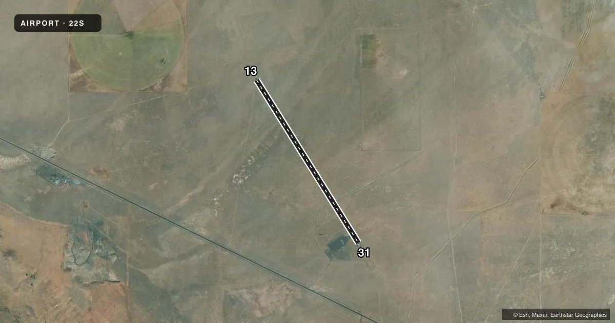
Full pagePattern entry · RWY 13
LEFT TRAFFICAirport sketch
Runways drawn to scale from FAA survey coordinates, rendered over satellite imagery. Not for navigation.
Approaches & charts
Services on the field
Fuel grades, oxygen, maintenance, ramp storage and lighting — as declared to the FAA by the airport operator.
Fuel & services
- Fuel
- Not available
- Oxygen (bottled)
- Not available
- Oxygen (bulk)
- Not available
- Airframe repair
- Not available
- Power plant repair
- Not available
Ramp & ground
- Transient storage
- Tie-down
- Landing fee
- No fee published
- Lighting schedule
- SS-SR
- Beacon schedule
- SS-SR
- Beacon
- White / Green (civil land)(WG)
- Wind indicator
- Yes
- Segmented circle
- Yes
Fuel & FBOs
Cheapest 100LL and Jet A on the field and nearby. Always confirm with the FBO before taxi.
Airport notes
Surface conditions, obstructions, local procedures, lighting outages and other notes published with each FAA cycle.
General notes
- TRAFFIC PATTERN ALTITUDE 1000' AGL.
- 4 FT FENCE, 40 FT FROM RY EDGE ALONG NE SIDE OF RY.
- FOR CD CTC SEATTLE ARTCC AT 253-351-3694.
Runway surface & condition
- 13/31RWY 13/31 EDGE LIGHTS SEVERAL NON FUNCTIONAL.
Approach & departure obstructions
- 13RWY HAS AIMING POINTS
Other notes
- ESTABD PRIOR TO 1959.
- OUTLINED BY WHITE TIRES; NON-STD.
VFR map & nearby airports
VFR sectional. Tap any ICAO chip to open that airport.
Key facts · 22S
Answer card- ICAO
- 22S
- Name
- PAISLEY
- Location
- PAISLEY, OREGON
- Elevation
- 4,395 ft MSL
- Traffic pattern altitude
- 5,395 ft MSL (1,000 AGL)
- Control tower
- Non-towered (use CTAF)
- Total runways
- 1
- Longest runway
- 13/31 · 4,300 ft
- Published ILS approaches
- 0
- Published frequencies
- 1
- Magnetic variation
- 18°
- Current flight rules
- VFR
- Current wind
- 000° at 0 kt
- Favored runway now
- –
Paisley Airport (22S) sits in Paisley, Oregon. Field elevation is 4,395 ft MSL. The airport has one runway. Runway 13/31 is 4,300 ft long and paved with asphalt. There is no control tower. CTAF is 122.9.
No ILS approaches are published here. The traffic pattern altitude is 5,395 ft MSL. That is 1,000 ft AGL at this field. The airport has aiming points on the runway. The segmented circle is non-standard and outlined by white tires. There is also a 4-foot fence about 40 feet from the runway edge along the northeast side of the runway, so pay close attention on rollout and taxi.
This is a high-elevation field. Density altitude can matter here, especially on warm days. Plan performance with that in mind. For clearance delivery, contact Seattle ARTCC at 253-351-3694. There are no on-field FBOs listed in the facts, so verify services with the airport operator or call ahead before you go. The field was established before 1959, so expect a basic rural airport setup rather than a full-service stop.