METAR & TAF A28
A28 does not publish a METAR.
Showing the nearest reporting station: KLKV (LAKE COUNTY) · 20.5 NM away. Conditions at A28 may differ.
METAR · KLKV
Observed 09:53Z
KLKV 270953Z AUTO 35005KT 10SM CLR 07/M02 A3017 RMK AO2 SLP182 T00721022
- Wind
- 350° @ 5 kt
- Visibility
- 10 SM
- Temp / Dew
- 7°C / -2°C
- Altimeter
- 30.17 inHg
- Clouds
- CLR
- Density alt
- 4,454 ft
- Ceiling
- Unlimited
- Rules
- VFR
Airport info & contacts
Manager on record, flight service, ARTCC, attendance schedule and pattern altitude — published by the FAA and refreshed every 28 days.
Location
- From city
- 1 NM N
- VFR sectional
- KLAMATH FALLS
- Pattern altitude
- 800 ft AGL · 5,416 ft MSL
- ARTCC
- ZSE · SEATTLE
- NOTAM facility
- RNO (NOTAM-D)
Airport manager
- Name
- MITCH CROSBY
- Phone
- (530) 233-4612
- Address
- 202 W 4TH ST, ALTURAS CA 96101
Flight service · Hours
- FSS RNO
- RENO1-800-WX-BRIEF
- Attendance
- Unattended
Frequencies
Tap any row to copy the frequency to your clipboard.
Runways & pattern
Full pagePattern entry · RWY 34
LEFT TRAFFICRunway end performance
| End | TORA | TODA | ASDA | LDA | VGSI | Approach lights | Obstruction |
|---|---|---|---|---|---|---|---|
| 16 | — | — | — | — | — | — | 10', road, 120' from thr, 0' R of cntrln, slope 12 |
Declared distances in feet. TORA = takeoff run available, TODA = takeoff distance, ASDA = accelerate-stop, LDA = landing distance.
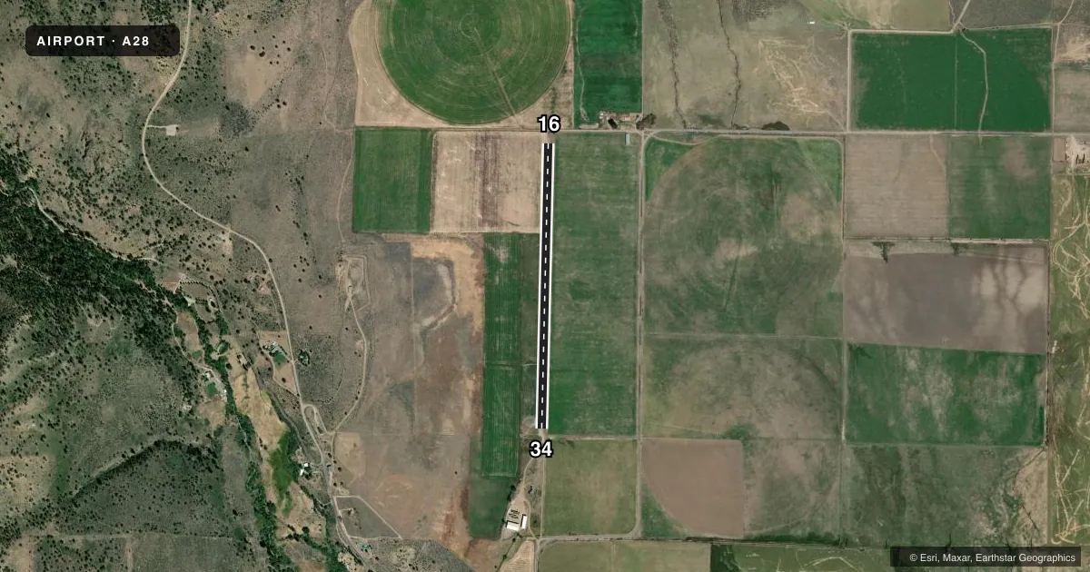
Airport sketch
Runways drawn to scale from FAA survey coordinates, rendered over satellite imagery. Not for navigation.
Approaches & charts
Services on the field
Fuel grades, oxygen, maintenance, ramp storage and lighting — as declared to the FAA by the airport operator.
Fuel & services
- Fuel
- Not available
- Oxygen (bottled)
- Not available
- Oxygen (bulk)
- Not available
- Airframe repair
- Not available
- Power plant repair
- Not available
Ramp & ground
- Transient storage
- Tie-down
- Landing fee
- No fee published
- Customs
- Not available
- Wind indicator
- Yes
- Segmented circle
- No
Fuel & FBOs
Cheapest 100LL and Jet A on the field and nearby. Always confirm with the FBO before taxi.
Airport notes
Surface conditions, obstructions, local procedures, lighting outages and other notes published with each FAA cycle.
General notes
- NO SNOW REMOVAL
- RUNWAY NOT REGULARLY MAINTAINED, GRAVEL AND ROCKS UP TO 4" DIAMETER ON RUNWAY
- + 4 FT FENCE, 75 FT EAST OF RWY CNTRLN FOR ENTIRE LEN OF RWY
- FOR CD CTC SEATTLE ARTCC AT 253-351-3694.
Other notes
- ESTABD PRIOR TO 15 MAY 1959.
- MANAGERROAD COMMISSIONER.
- MANAGERROAD DEPARTMENT, ALTURAS.
VFR map & nearby airports
VFR sectional. Tap any ICAO chip to open that airport.
Key facts · A28
Answer card- ICAO
- A28
- Name
- FORT BIDWELL
- Location
- FORT BIDWELL, CALIFORNIA
- Elevation
- 4,616 ft MSL
- Traffic pattern altitude
- 5,416 ft MSL (800 AGL)
- Control tower
- Non-towered (use CTAF)
- Total runways
- 1
- Longest runway
- 16/34 · 3,660 ft
- Published ILS approaches
- 0
- Published frequencies
- 1
- Magnetic variation
- 17°
- Current flight rules
- VFR
- Current wind
- 350° at 5 kt
- Favored runway now
- RWY 34
Fort Bidwell Airport (A28) sits in Fort Bidwell, California. Field elevation is 4,616 ft MSL. It has one runway, 16/34, which is 3,660 ft long and surfaced gravel-dirt. The runway headings are magnetic 181° and 1°. There is no control tower. CTAF is 122.9.
Pattern altitude is 800 ft AGL, which puts the traffic pattern at 5,416 ft MSL. No ILS approaches are published here. That matters for planning because this is a high-elevation strip with no tower and no published precision approach support.
The published remarks are important. The runway is not regularly maintained. Expect gravel and rocks up to 4 inches in diameter on the runway. There is also a 4-foot fence 75 feet east of the runway centerline for the full length of the runway. No snow removal is provided. For clearance delivery, contact Seattle ARTCC at 253-351-3694. The manager is the Road Commissioner. The manager's phone is the Road Department in Alturas.
No on-field FBOs are listed. Verify current services with the airport operator before you go. For a first-time arrival, treat this as a rough-field operation at elevation. Check performance. Check runway condition. Check wind before committing.