METAR & TAF A26
A26 does not publish a METAR.
Showing the nearest reporting station: KAAT (ALTURAS MUNI) · 25.0 NM away. Conditions at A26 may differ.
METAR · KAAT
Observed 11:55Z
KAAT 271155Z AUTO 00000KT 10SM CLR 07/M01 A3017 RMK AO2 SLP178 T00721011 10183 20072 53004 $
- Wind
- 000° @ 0 kt
- Visibility
- 10 SM
- Temp / Dew
- 7°C / -1°C
- Altimeter
- 30.17 inHg
- Clouds
- CLR
- Density alt
- 3,980 ft
- Ceiling
- Unlimited
- Rules
- VFR
Airport info & contacts
Manager on record, flight service, ARTCC, attendance schedule and pattern altitude — published by the FAA and refreshed every 28 days.
Location
- From city
- 1 NM SW
- VFR sectional
- KLAMATH FALLS
- Pattern altitude
- 800 ft AGL · 5,034 ft MSL
- ARTCC
- ZSE · SEATTLE
- NOTAM facility
- RIU (NOTAM-D)
Airport manager
- Name
- MITCH CROSBY
- Phone
- 530-233-6412
- Address
- 202 W 4TH STREET, ALTURAS CA 96101
Flight service · Hours
- FSS RIU
- RANCHO MURIETA1-800-WX-BRIEF
- Attendance
- Unattended
Frequencies
Tap any row to copy the frequency to your clipboard.
Runways & pattern
Full pagePattern entry · RWY 09
LEFT TRAFFICRunway end performance
| End | TORA | TODA | ASDA | LDA | VGSI | Approach lights | Obstruction |
|---|---|---|---|---|---|---|---|
| 27 | — | — | — | — | — | — | 10', road, 200' from thr, 25' R of cntrln, slope 0 |
Declared distances in feet. TORA = takeoff run available, TODA = takeoff distance, ASDA = accelerate-stop, LDA = landing distance.
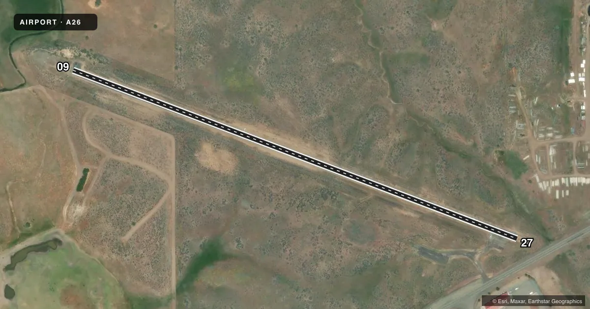
Airport sketch
Runways drawn to scale from FAA survey coordinates, rendered over satellite imagery. Not for navigation.
Approaches & charts
Services on the field
Fuel grades, oxygen, maintenance, ramp storage and lighting — as declared to the FAA by the airport operator.
Fuel & services
- Fuel
- Not available
- Oxygen (bottled)
- Not available
- Oxygen (bulk)
- Not available
- Airframe repair
- Not available
- Power plant repair
- Not available
Ramp & ground
- Transient storage
- Tie-down
- Landing fee
- No fee published
- Wind indicator
- Yes
- Segmented circle
- No
Fuel & FBOs
Cheapest 100LL and Jet A on the field and nearby. Always confirm with the FBO before taxi.
Airport notes
Surface conditions, obstructions, local procedures, lighting outages and other notes published with each FAA cycle.
General notes
- FOR CD CTC SEATTLE ARTCC AT 253-351-3694.
Approach & departure obstructions
- 27+5' FNC & +10' ROAD OBSTN, 20' FROM RY END, 125'L.
- 27+10' ROAD OBSTN 306', 125'L, 30:1 BASED ON DISPLCD THR.
Other notes
- PREDATES TO 1958 FAA ACT.
- MANAGERROADS DEPARTMENT.
VFR map & nearby airports
VFR sectional. Tap any ICAO chip to open that airport.
Key facts · A26
Answer card- ICAO
- A26
- Name
- ADIN
- Location
- ADIN, CALIFORNIA
- Elevation
- 4,234 ft MSL
- Traffic pattern altitude
- 5,034 ft MSL (800 AGL)
- Control tower
- Non-towered (use CTAF)
- Total runways
- 1
- Longest runway
- 09/27 · 2,850 ft
- Published ILS approaches
- 0
- Published frequencies
- 1
- Magnetic variation
- 17°
- Current flight rules
- VFR
- Current wind
- 000° at 0 kt
- Favored runway now
- –
ADIN Airport (A26) sits in Adin, California. Field elevation is 4,234 ft MSL. The airport has one runway. Runway 09/27 is 2,850 ft long with an asphalt surface. This is an unattended field with no control tower, so CTAF is the main traffic frequency at 122.9. Pattern altitude is 800 ft AGL, which is 5,034 ft MSL.
No ILS approaches are published here. Plan for VFR work or check the current FAA Chart Supplement for any approach details or local operating notes before you go. The published remarks also call out runway-end obstructions. On runway 27 there is a road and a fence near the departure end. The road is farther out, with a displaced-threshold note tied to obstacle clearance. That makes a careful runway check and takeoff planning important, especially with the field sitting above 4,000 ft MSL.
No on-field FBOs are listed in the facts. Contact the airport operator directly or call the field on CTAF for current services before arrival. The published remarks also say clearance delivery is handled through Seattle ARTCC at 253-351-3694. For a first visit, pay close attention to density altitude, runway length and the obstacle environment at the ends of the strip.