METAR & TAF O39
O39 does not publish a METAR.
Showing the nearest reporting station: KSVE (SUSANVILLE MUNI) · 27.4 NM away. Conditions at O39 may differ.
METAR · KSVE
Observed 10:35Z
KSVE 271035Z AUTO 00000KT 10SM CLR 11/M02 A3015 RMK A01 P000
- Wind
- 000° @ 0 kt
- Visibility
- 10 SM
- Temp / Dew
- 11°C / -2°C
- Altimeter
- 30.15 inHg
- Clouds
- CLR
- Density alt
- 5,814 ft
- Ceiling
- Unlimited
- Rules
- VFR
Airport info & contacts
Manager on record, flight service, ARTCC, attendance schedule and pattern altitude — published by the FAA and refreshed every 28 days.
Location
- From city
- 0 NM N
- VFR sectional
- KLAMATH FALLS
- Pattern altitude
- 800 ft AGL · 6,106 ft MSL
- ARTCC
- ZOA · OAKLAND
- NOTAM facility
- RNO (NOTAM-D)
Airport manager
- Name
- KAYLA NEELY
- Phone
- 530-251-8289
- Address
- 707 NEVADA ST, SUSANVILLE CA 96130
Flight service · Hours
- FSS RNO
- RENO1-800-WX-BRIEF
- Attendance
- Unattended
Frequencies
Tap any row to copy the frequency to your clipboard.
Runways & pattern
Full pagePattern entry · RWY 17
LEFT TRAFFICRunway end performance
| End | TORA | TODA | ASDA | LDA | VGSI | Approach lights | Obstruction |
|---|---|---|---|---|---|---|---|
| 35 | — | — | — | — | — | — | 50', pole, 200' from thr, 0' R of cntrln, slope 0 |
Declared distances in feet. TORA = takeoff run available, TODA = takeoff distance, ASDA = accelerate-stop, LDA = landing distance.
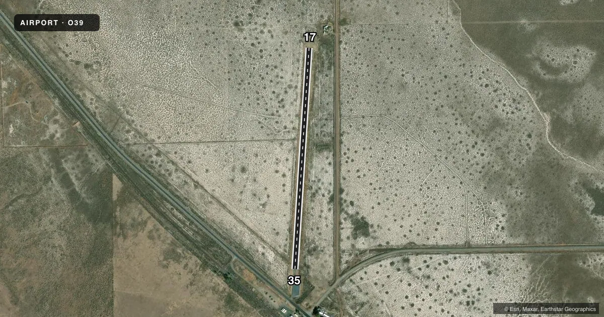
Airport sketch
Runways drawn to scale from FAA survey coordinates, rendered over satellite imagery. Not for navigation.
Approaches & charts
Services on the field
Fuel grades, oxygen, maintenance, ramp storage and lighting — as declared to the FAA by the airport operator.
Fuel & services
- Fuel
- Not available
- Oxygen (bottled)
- Not available
- Oxygen (bulk)
- Not available
- Airframe repair
- Not available
- Power plant repair
- Not available
Ramp & ground
- Transient storage
- Tie-down
- Landing fee
- No fee published
- Wind indicator
- Yes
- Segmented circle
- No
Fuel & FBOs
Cheapest 100LL and Jet A on the field and nearby. Always confirm with the FBO before taxi.
Airport notes
Surface conditions, obstructions, local procedures, lighting outages and other notes published with each FAA cycle.
General notes
- UNPAVED AREAS EXTREMELY SOFT WHEN WET.
- FOR CD CTC OAKLAND ARTCC AT 510-745-3380.
Approach & departure obstructions
- 35HIGHWAY 20 FT FM THLD +65 FT TREE 150 FT FM THLD.
- 35RWY 35 APCH RATIO TO DSPLCD THLD 34:1; APCH RATIO TO DSPLCD THLD FM 32' TELEPHONE POLE
Other notes
- MANAGERLASSEN COUNTY DEPUTY DIRECTOR OF PUBLIC WORKS.
- MANAGERPUBLIC WORKS OFFICE; SUSANVILLE; CA.
VFR map & nearby airports
VFR sectional. Tap any ICAO chip to open that airport.
Key facts · O39
Answer card- ICAO
- O39
- Name
- RAVENDALE
- Location
- RAVENDALE, CALIFORNIA
- Elevation
- 5,306 ft MSL
- Traffic pattern altitude
- 6,106 ft MSL (800 AGL)
- Control tower
- Non-towered (use CTAF)
- Total runways
- 1
- Longest runway
- 17/35 · 2,607 ft
- Published ILS approaches
- 0
- Published frequencies
- 1
- Magnetic variation
- 17°
- Current flight rules
- VFR
- Current wind
- 000° at 0 kt
- Favored runway now
- –
Ravendale Airport sits in Ravendale, California. Field elevation is 5,306 ft MSL. The airport has one runway, 17/35, which is 2,607 ft long and asphalt. There is no control tower. CTAF is 122.9. No ILS approaches are published here.
Pattern altitude is 800 ft AGL. That puts the traffic pattern at 6,106 ft MSL. The field sits high enough that density altitude will matter on warm days. Expect reduced climb performance compared with lower-elevation airports. The published remarks also call out soft unpaved areas when wet. Stay on the paved surfaces when conditions are questionable.
There are no on-field FBOs listed. Plan on self-briefing current airport details before you go. The published remarks also note runway 35 has nearby obstructions, including a highway close to the threshold and a 65-foot tree near the approach end. For clearance delivery, contact Oakland ARTCC at 510-745-3380. If you need current operational details, check the current FAA Chart Supplement or call the airport operator directly before departure.