METAR & TAF H37
H37 does not publish a METAR.
Showing the nearest reporting station: KSVE (SUSANVILLE MUNI) · 22.9 NM away. Conditions at H37 may differ.
METAR · KSVE
Observed 11:55Z
KSVE 271155Z AUTO 27003KT 10SM CLR 10/M01 A3017 RMK A01 P000
- Wind
- 270° @ 3 kt
- Visibility
- 10 SM
- Temp / Dew
- 10°C / -1°C
- Altimeter
- 30.17 inHg
- Clouds
- CLR
- Density alt
- 4,127 ft
- Ceiling
- Unlimited
- Rules
- VFR
Airport info & contacts
Manager on record, flight service, ARTCC, attendance schedule and pattern altitude — published by the FAA and refreshed every 28 days.
Location
- From city
- 2 NM W
- VFR sectional
- KLAMATH FALLS
- Pattern altitude
- 800 ft AGL · 4,862 ft MSL
- ARTCC
- ZOA · OAKLAND
- NOTAM facility
- RNO (NOTAM-D)
Airport manager
- Name
- PETE HEIMBIGNER
- Phone
- 530-251-8289
- Address
- 707 NEVADA ST, SUSANVILLE CA 96130
Flight service · Hours
- FSS RNO
- RENO1-800-WX-BRIEF
- Attendance
- Unattended
Frequencies
Tap any row to copy the frequency to your clipboard.
Runways & pattern
Full pagePattern entry · RWY 24
LEFT TRAFFICRunway end performance
| End | TORA | TODA | ASDA | LDA | VGSI | Approach lights | Obstruction |
|---|---|---|---|---|---|---|---|
| 06 | — | — | — | — | — | — | 40', pline, 1125' from thr, 0' R of cntrln, slope 23 |
| 24 | — | — | — | — | — | — | 40', pline, 800' from thr, 0' R of cntrln, slope 15 |
Declared distances in feet. TORA = takeoff run available, TODA = takeoff distance, ASDA = accelerate-stop, LDA = landing distance.
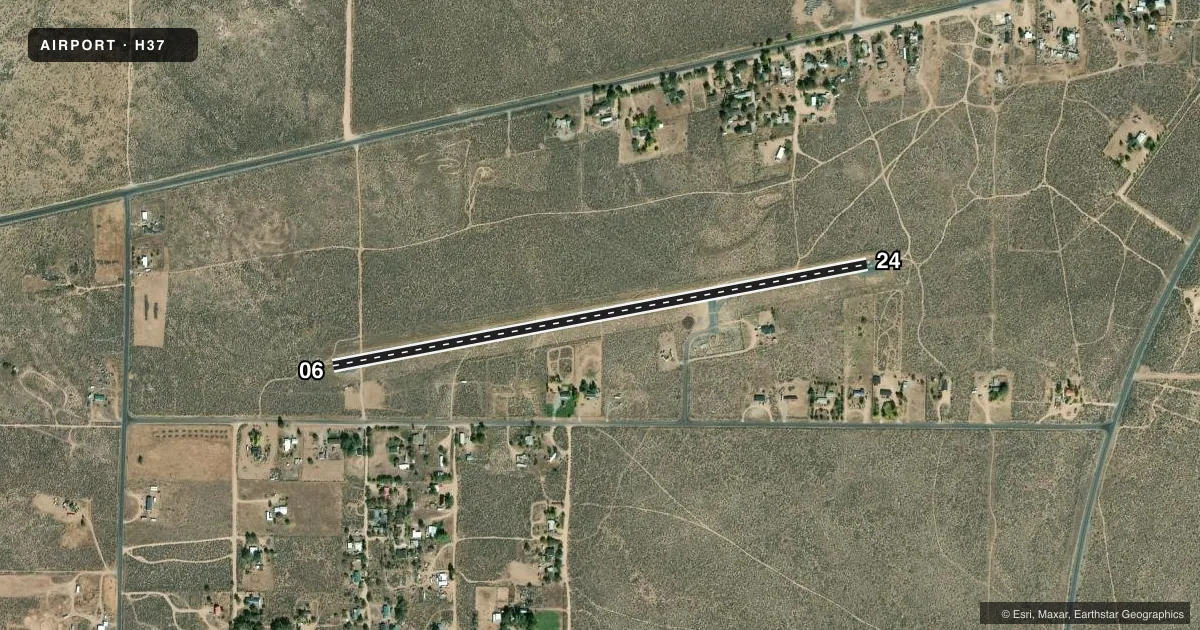
Airport sketch
Runways drawn to scale from FAA survey coordinates, rendered over satellite imagery. Not for navigation.
Approaches & charts
Services on the field
Fuel grades, oxygen, maintenance, ramp storage and lighting — as declared to the FAA by the airport operator.
Fuel & services
- Fuel
- Not available
- Oxygen (bottled)
- Not available
- Oxygen (bulk)
- Not available
- Airframe repair
- Not available
- Power plant repair
- Not available
Ramp & ground
- Transient storage
- Tie-down
- Landing fee
- No fee published
- Wind indicator
- Yes
- Segmented circle
- Yes
Fuel & FBOs
Cheapest 100LL and Jet A on the field and nearby. Always confirm with the FBO before taxi.
Airport notes
Surface conditions, obstructions, local procedures, lighting outages and other notes published with each FAA cycle.
General notes
- +5FT BRUSH ALONG NORTHSIDE; 45 FT FROM RY CNTRLN.
- FOR CD CTC OAKLAND ARTCC AT 510-745-3380.
Approach & departure obstructions
- 24PWR LINE MKD WITH AVN ORANGE SPHERICAL MARKERS.
Other notes
- MANAGERLASSEN COUNTY DEPUTY DIRECTOR OF PUBLIC WORKS.
- MANAGERLASSEN COUNTY PUBLIC WORKS OFFICE.
VFR map & nearby airports
VFR sectional. Tap any ICAO chip to open that airport.
Key facts · H37
Answer card- ICAO
- H37
- Name
- HERLONG
- Location
- HERLONG, CALIFORNIA
- Elevation
- 4,062 ft MSL
- Traffic pattern altitude
- 4,862 ft MSL (800 AGL)
- Control tower
- Non-towered (use CTAF)
- Total runways
- 1
- Longest runway
- 06/24 · 3,260 ft
- Published ILS approaches
- 0
- Published frequencies
- 1
- Magnetic variation
- 16°
- Current flight rules
- VFR
- Current wind
- 270° at 3 kt
- Favored runway now
- RWY 24
Herlong Airport sits in Herlong, California. Field elevation is 4,062 ft MSL. The airport has one runway. Runway 06/24 is 3,260 ft long with an asphalt surface. There is no control tower. CTAF is 122.9. The published pattern altitude is 800 ft AGL, which is 4,862 ft MSL.
No ILS approaches are published here. Plan for a non-towered mountain-field style arrival and keep an eye on density altitude. The field sits high enough that performance planning matters, especially on warm days. Published remarks call out +5 foot brush along the north side, 45 ft from the runway centerline. A power line marked with orange spherical markers is near the runway 24 end. That is worth a close look on final and during the departure roll.
There are no on-field FBOs listed in the facts. Contact the airport operator directly if you need current services before arrival. For clearance delivery, the published remark says to contact Oakland ARTCC at 510-745-3380. If you want current noise, curfew, or airport-use guidance, check the current FAA Chart Supplement before you go.