METAR & TAF O02
O02 does not publish a METAR.
Showing the nearest reporting station: KRTS (RENO/STEAD) · 23.8 NM away. Conditions at O02 may differ.
METAR · KRTS
Observed 12:15Z
KRTS 271215Z AUTO 35007KT 10SM CLR 10/M07 A3019 RMK AO2
- Wind
- 350° @ 7 kt
- Visibility
- 10 SM
- Temp / Dew
- 10°C / -7°C
- Altimeter
- 30.19 inHg
- Clouds
- CLR
- Density alt
- 5,141 ft
- Ceiling
- Unlimited
- Rules
- VFR
Airport info & contacts
Manager on record, flight service, ARTCC, attendance schedule and pattern altitude — published by the FAA and refreshed every 28 days.
Location
- From city
- 1 NM E
- VFR sectional
- SAN FRANCISCO
- ARTCC
- ZOA · OAKLAND
- NOTAM facility
- RNO (NOTAM-D)
Airport manager
- Name
- NICK COLLIN
- Phone
- 530-283-6069
- Address
- 198 ANDY'S WAY, QUINCY CA 95971
Flight service · Hours
- FSS RNO
- RENO1-800-WX-BRIEF
- Attendance
- 0800-1900
Frequencies
Tap any row to copy the frequency to your clipboard.
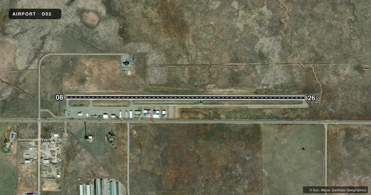
Runways & pattern
Full pagePattern entry · RWY 26
LEFT TRAFFICRunway end performance
| End | TORA | TODA | ASDA | LDA | VGSI | Approach lights | Obstruction |
|---|---|---|---|---|---|---|---|
| 08 | — | — | — | — | — | — | 15', road, 510' from thr, 160' R of cntrln, slope 20 |
| 26 | — | — | — | — | PAPI 2-box left(3.5°) | — | 3', fence, 270' from thr, 0' R of cntrln, slope 23 |
Declared distances in feet. TORA = takeoff run available, TODA = takeoff distance, ASDA = accelerate-stop, LDA = landing distance.
Airport sketch
Runways drawn to scale from FAA survey coordinates, rendered over satellite imagery. Not for navigation.
Approaches & charts
Services on the field
Fuel grades, oxygen, maintenance, ramp storage and lighting — as declared to the FAA by the airport operator.
Fuel & services
- Fuel
- 100LLA
- Oxygen (bottled)
- Not available
- Oxygen (bulk)
- Not available
- Airframe repair
- Major
- Power plant repair
- Major
- Other services
- INSTR,RNTL,SALES
Ramp & ground
- Transient storage
- Tie-down
- Landing fee
- No fee published
- Customs
- Not available
- Lighting schedule
- SEE RMK
- Beacon schedule
- SS-SR
- Beacon
- White / Green (civil land)(WG)
- Wind indicator
- Lighted
- Segmented circle
- Yes
Fuel & FBOs
Cheapest 100LL and Jet A on the field and nearby. Always confirm with the FBO before taxi.
Airport notes
Surface conditions, obstructions, local procedures, lighting outages and other notes published with each FAA cycle.
General notes
- FOR CD CTC NORCAL APCH AT 916-361-0596.
- COLD TEMPERATURE AIRPORT. ALTITUDE CORRECTION REQUIRED AT OR BELOW -13C.
Lighting notes
- ACTVT MIRL RY 08/26 - CTAF.
Other notes
- MANAGERFBO PHONE 530-616-0310.
VFR map & nearby airports
VFR sectional. Tap any ICAO chip to open that airport.
Key facts · O02
Answer card- ICAO
- O02
- Name
- NERVINO
- Location
- BECKWOURTH, CALIFORNIA
- Elevation
- 4,899.9 ft MSL
- Traffic pattern altitude
- 5,899.9 ft MSL (1,000 AGL)
- Control tower
- Non-towered (use CTAF)
- Total runways
- 1
- Longest runway
- 08/26 · 4,651 ft
- Published ILS approaches
- 0
- Published frequencies
- 4
- Magnetic variation
- 14°
- Current flight rules
- VFR
- Current wind
- 350° at 7 kt
- Favored runway now
- RWY 26
Nervino Airport (O02) is in Beckwourth, California. The field elevation is 4,899.9 ft MSL, so performance planning matters here. It has one runway, 08/26, which is 4,651 ft long and paved asphalt. There is no control tower. CTAF and UNICOM are both 122.8. NorCal Approach handles approach and departure services on 126.3 and 353.9.
No ILS approaches are published. Pattern altitude is not published in the facts, so verify the current Chart Supplement before you fly. The airport is a cold temperature airport. Altitude correction is required at or below minus 13 degrees Celsius. That is worth checking on a winter morning.
Nervino Airport is home to Nervino Airport FBO. It carries 100LL and Jet A. The published remarks also note that medium intensity runway lights on 08/26 are activated by using CTAF. For clearance delivery, contact NorCal Approach at 916-361-0596. The FBO phone number in the remarks is 530-616-0310. If you are new to the field, plan for the elevation. Verify the lighting procedure. Review the current Chart Supplement for any other local notes before arrival.