METAR & TAF 2O1
2O1 does not publish a METAR.
Showing the nearest reporting station: KSVE (SUSANVILLE MUNI) · 31.1 NM away. Conditions at 2O1 may differ.
METAR · KSVE
Observed 16:35Z
KSVE 261635Z AUTO 08003KT 10SM CLR 24/03 A3017 RMK A01 P000
- Wind
- 080° @ 3 kt
- Visibility
- 10 SM
- Temp / Dew
- 24°C / 3°C
- Altimeter
- 30.17 inHg
- Clouds
- CLR
- Density alt
- 5,009 ft
- Ceiling
- Unlimited
- Rules
- VFR
Airport info & contacts
Manager on record, flight service, ARTCC, attendance schedule and pattern altitude — published by the FAA and refreshed every 28 days.
Location
- From city
- 1 NM N
- VFR sectional
- SAN FRANCISCO
- ARTCC
- ZOA · OAKLAND
- NOTAM facility
- RIU (NOTAM-D)
Airport manager
- Name
- NICK COLLIN
- Phone
- 530-283-6069
- Address
- 198 ANDY'S WAY, QUINCY CA 95971-7007
Flight service · Hours
- FSS RIU
- RANCHO MURIETA1-800-WX-BRIEF
- Attendance
- Unattended
Frequencies
Tap any row to copy the frequency to your clipboard.
Runways & pattern
Full pagePattern entry · RWY 07
LEFT TRAFFICRunway end performance
| End | TORA | TODA | ASDA | LDA | VGSI | Approach lights | Obstruction |
|---|---|---|---|---|---|---|---|
| 07 | — | — | — | — | — | — | 19', road, 350' from thr, 0' R of cntrln, slope 7 |
| 25 | — | — | — | — | PAPI 2-box left(3°) | — | — |
Declared distances in feet. TORA = takeoff run available, TODA = takeoff distance, ASDA = accelerate-stop, LDA = landing distance.
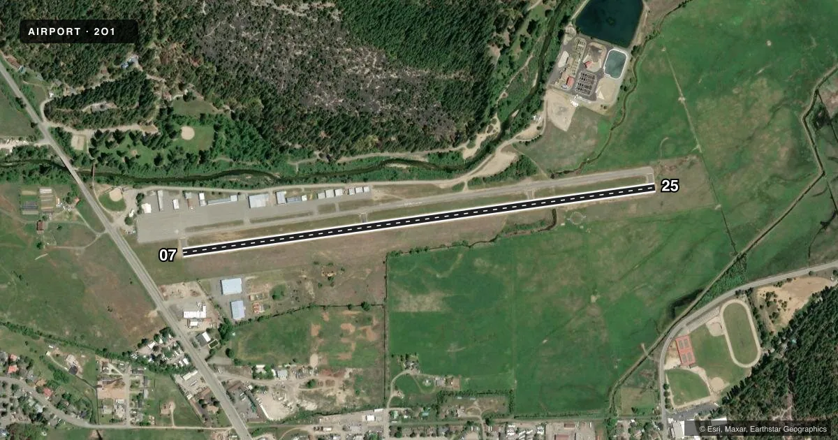
Airport sketch
Runways drawn to scale from FAA survey coordinates, rendered over satellite imagery. Not for navigation.
Approaches & charts
Services on the field
Fuel grades, oxygen, maintenance, ramp storage and lighting — as declared to the FAA by the airport operator.
Fuel & services
- Fuel
- 100LL
- Oxygen (bottled)
- Not available
- Oxygen (bulk)
- Not available
- Airframe repair
- Not available
- Power plant repair
- Not available
Ramp & ground
- Transient storage
- Tie-down
- Landing fee
- No fee published
- Customs
- Not available
- Lighting schedule
- SEE RMK
- Beacon schedule
- SS-SR
- Beacon
- White / Green (civil land)(WG)
- Wind indicator
- Lighted
- Segmented circle
- Yes
Fuel & FBOs
Cheapest 100LL and Jet A on the field and nearby. Always confirm with the FBO before taxi.
Airport notes
Surface conditions, obstructions, local procedures, lighting outages and other notes published with each FAA cycle.
General notes
- DUE TO PROXIMITY OF TERRAIN NRML OPNS ARE: FOR DEPS/TOUCH AND GO RWY 07. LDGS ON RWYS 07 AND 25.
- ULTRALIGHTS ON AND INVOF ARPT.
- RAPIDLY RISING TERRAIN WITH +100 FT TREES ON NORTH SIDE OF RY.
- APRT RESTRICTED BY APRT OPER TO ACFT WITH MAX CERT TKOF WEIGHT OF 12,500 LBS OR LESS.
- FIREFIGHTING ACFT INVOF ARPT MAY-OCT.
- FOR CD CTC NORCAL APCH AT 916-361-6874.
Lighting notes
- ROTG BCN LOCATED 2000 FT NORTH OF ARPT ON TOP OF HILL. SECONDARY WHITE BCN 3 MI SOUTH OF ARPT.
- ACTVT MIRL RWY 07/25 - CTAF.
Fuel notes
- 100LL24 HR 100LL FUEL BY CREDIT CARD.
Approach & departure obstructions
- 07RWY 07 +19 FT ROAD 350 FT FM RWY 7 END 7:1 CLEARANCE SLOPE TO THLD.
Other notes
- PREDATES TO 1958 FA ACT.
- MANAGERDIRECTOR OF FACILITIES AND AIRPORTS.
- MANAGERFAC AND ARPTS OFC IN QUINCY. PHONE 530-283-6299.
VFR map & nearby airports
VFR sectional. Tap any ICAO chip to open that airport.
Key facts · 2O1
Answer card- ICAO
- 2O1
- Name
- GANSNER FLD
- Location
- QUINCY, CALIFORNIA
- Elevation
- 3,418.6 ft MSL
- Traffic pattern altitude
- 4,418.6 ft MSL (1,000 AGL)
- Control tower
- Non-towered (use CTAF)
- Total runways
- 1
- Longest runway
- 07/25 · 4,105 ft
- Published ILS approaches
- 0
- Published frequencies
- 2
- Magnetic variation
- 17°
- Current flight rules
- VFR
- Current wind
- 080° at 3 kt
- Favored runway now
- RWY 07
Gansner Field is in Quincy, California. The field elevation is 3,418.6 ft MSL. It has one runway, 07/25, which is 4,105 ft long. There is no control tower. Medium intensity runway lights for 07/25 are activated by the CTAF. No ILS approaches are published.
The pattern altitude is not published. Use the standard 1,000 ft AGL for light piston traffic unless the current FAA Chart Supplement says otherwise. The on-field FBO is Gansner Field. It carries 100LL. Twenty-four hour 100LL fuel is available by credit card. The airport also has a published clearance delivery contact with NorCal Approach for IFR work.
This is a mountain airport with terrain to respect. There is rapidly rising terrain with trees over 100 ft tall on the north side of the runway. Normal operations are departures and touch-and-goes on runway 07. Landings are permitted on 07 and 25. Runway 07 also has a road obstacle near the departure end, so plan your takeoff and climb carefully. Firefighting aircraft operate in the area from May through October. Ultralight traffic also uses the airport. Check the current FAA Chart Supplement for any noise or operational updates before you go.