METAR & TAF O79
O79 does not publish a METAR.
Showing the nearest reporting station: KTRK (TRUCKEE-TAHOE) · 18.6 NM away. Conditions at O79 may differ.
METAR · KTRK
Observed 06:15Z
KTRK 270615Z AUTO 16003KT 10SM CLR 09/M01 A3028 RMK AO2
- Wind
- 160° @ 3 kt
- Visibility
- 10 SM
- Temp / Dew
- 9°C / -1°C
- Altimeter
- 30.28 inHg
- Clouds
- CLR
- Density alt
- 5,021 ft
- Ceiling
- Unlimited
- Rules
- VFR
Airport info & contacts
Manager on record, flight service, ARTCC, attendance schedule and pattern altitude — published by the FAA and refreshed every 28 days.
Location
- From city
- 1 NM SE
- VFR sectional
- SAN FRANCISCO
- Pattern altitude
- 800 ft AGL · 5,790 ft MSL
- ARTCC
- ZOA · OAKLAND
- NOTAM facility
- RNO (NOTAM-D)
Airport manager
- Name
- BRIAN DAVEY
- Phone
- (530) 289-3201
- Address
- PO BOX 98, DOWNIEVILLE CA 95936
Flight service · Hours
- FSS RNO
- RENO1-800-WX-BRIEF
- Attendance
- Unattended
Frequencies
Tap any row to copy the frequency to your clipboard.
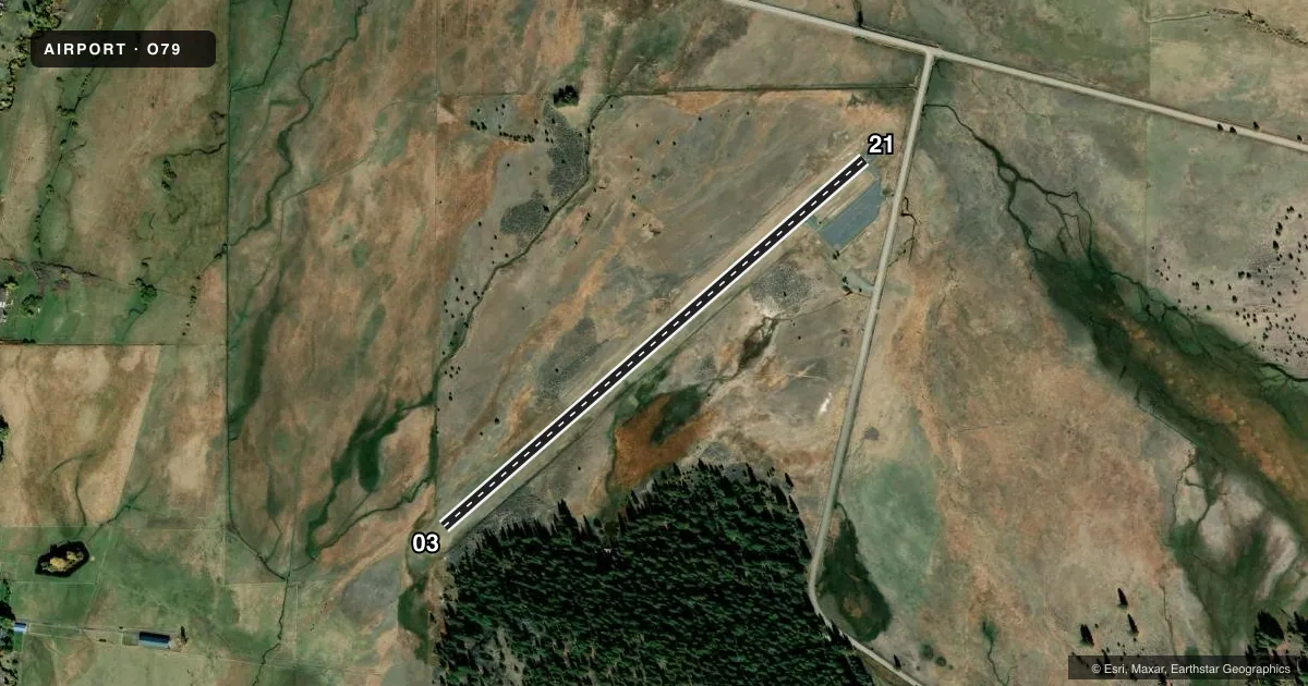
Runways & pattern
Full pagePattern entry · RWY 21
RIGHT TRAFFICAirport sketch
Runways drawn to scale from FAA survey coordinates, rendered over satellite imagery. Not for navigation.
Approaches & charts
Services on the field
Fuel grades, oxygen, maintenance, ramp storage and lighting — as declared to the FAA by the airport operator.
Fuel & services
- Fuel
- Not available
- Oxygen (bottled)
- Not available
- Oxygen (bulk)
- Not available
- Airframe repair
- Not available
- Power plant repair
- Not available
Ramp & ground
- Transient storage
- Tie-down
- Landing fee
- No fee published
- Customs
- Not available
- Wind indicator
- Yes
- Segmented circle
- Yes
Fuel & FBOs
Cheapest 100LL and Jet A on the field and nearby. Always confirm with the FBO before taxi.
Airport notes
Surface conditions, obstructions, local procedures, lighting outages and other notes published with each FAA cycle.
General notes
- FOR CD CTC OAKLAND ARTCC AT 510-745-3380.
Lighting notes
- ULTRALIGHT ACTIVITY ON & INVOF ARPT.
Other notes
- MANAGERSIERRA COUNTY PUBLIC WORKS DIRECTOR. TRANSPORTATION@SIERRACOUNTY.CA.GOV
- MANAGERSIERRA COUNTY PUBLIC WORKS DEPARTMENT, DOWNIEVILLE.
- 03/21PAVEMENT IS CRUMBLING IN AREAS AND CRACKING.
VFR map & nearby airports
VFR sectional. Tap any ICAO chip to open that airport.
Key facts · O79
Answer card- ICAO
- O79
- Name
- SIERRAVILLE DEARWATER
- Location
- SIERRAVILLE, CALIFORNIA
- Elevation
- 4,989.7 ft MSL
- Traffic pattern altitude
- 5,789.7 ft MSL (800 AGL)
- Control tower
- Non-towered (use CTAF)
- Total runways
- 1
- Longest runway
- 03/21 · 3,093 ft
- Published ILS approaches
- 0
- Published frequencies
- 1
- Magnetic variation
- 16°
- Current flight rules
- VFR
- Current wind
- 160° at 3 kt
- Favored runway now
- RWY 21
Sierraville Dearwater Airport sits in Sierraville, California. The field elevation is 4,989.7 ft MSL. It has one runway, 03/21, which is 3,093 ft long and surfaced with asphalt-dirt. The airport is non-towered. CTAF is 122.9. Pattern altitude is 800 ft AGL, which is 5,789.7 ft MSL.
No ILS approaches are published here. That matters if you are planning an IFR arrival. Check the current FAA Chart Supplement for the latest approach data and any airport remarks before you go. Published remarks note that runway 03/21 pavement is crumbling in areas and cracking. Ultralight activity also occurs on and near the airport, so keep a sharp scan in the pattern and on final.
There are no on-field FBOs listed. Contact the airport operator directly before arrival, or call the field on CTAF for current service availability. The airport manager is the Sierra County Public Works Director. Sierra County Public Works Department in Downieville can also handle airport management questions. For clearance delivery, contact Oakland ARTCC at 510-745-3380. With the field sitting near 5,000 ft MSL, expect mountain-field performance planning to matter on warm days. Use the runway and density altitude picture you get on the day of flight, then make your go or no-go call with margin.