METAR & TAF KBLU
Current METAR
Observed 01:52Z
KBLU 270152Z AUTO 23006KT 10SM CLR 23/01 A3023 RMK AO2 SLP141 T02280011 $
- Wind
- 230° @ 6 kt
- Visibility
- 10 SM
- Temp / Dew
- 23°C / 1°C
- Altimeter
- 30.23 inHg
- Clouds
- CLR
- Density alt
- 7,127 ft
- Ceiling
- Unlimited
- Rules
- VFR
Airport info & contacts
Manager on record, flight service, ARTCC, attendance schedule and pattern altitude — published by the FAA and refreshed every 28 days.
Location
- From city
- 1 NM S
- VFR sectional
- SAN FRANCISCO
- ARTCC
- ZOA · OAKLAND
- NOTAM facility
- BLU (NOTAM-D)
Airport manager
- Name
- KEVIN ORDWAY
- Phone
- 530-745-3576
- Address
- 3091 COUNTY CTR DR. SUITE 220, AUBURN CA 95603
Flight service · Hours
- FSS RIU
- RANCHO MURIETA1-800-WX-BRIEF
- Attendance
- Unattended
Frequencies
Tap any row to copy the frequency to your clipboard.
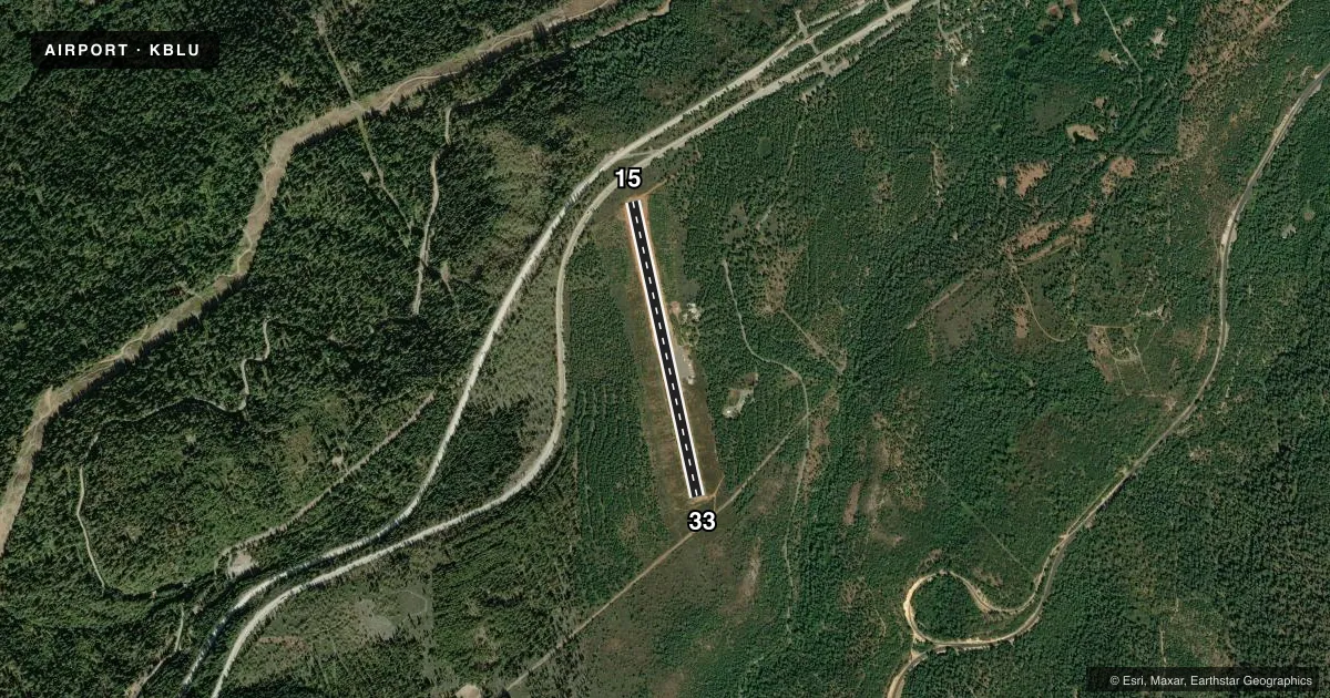
Runways & pattern
Full pagePattern entry · RWY 15
LEFT TRAFFICRunway end performance
| End | TORA | TODA | ASDA | LDA | VGSI | Approach lights | Obstruction |
|---|---|---|---|---|---|---|---|
| 15 | — | — | — | — | — | — | 20', tree, 750' from thr, 110' R of cntrln, slope 27 |
| 33 | — | — | — | — | — | — | 15', tree, 400' from thr, 0' R of cntrln, slope 13 |
Declared distances in feet. TORA = takeoff run available, TODA = takeoff distance, ASDA = accelerate-stop, LDA = landing distance.
Airport sketch
Runways drawn to scale from FAA survey coordinates, rendered over satellite imagery. Not for navigation.
Approaches & charts
Services on the field
Fuel grades, oxygen, maintenance, ramp storage and lighting — as declared to the FAA by the airport operator.
Fuel & services
- Fuel
- Not available
- Oxygen (bottled)
- Not available
- Oxygen (bulk)
- Not available
- Airframe repair
- Not available
- Power plant repair
- Not available
Ramp & ground
- Transient storage
- Tie-down
- Landing fee
- No fee published
- Customs
- Not available
- Beacon
- White / Green (civil land)(WG)
- Wind indicator
- Lighted
- Segmented circle
- No
Fuel & FBOs
Cheapest 100LL and Jet A on the field and nearby. Always confirm with the FBO before taxi.
Airport notes
Surface conditions, obstructions, local procedures, lighting outages and other notes published with each FAA cycle.
General notes
- ARPT CLSD SS-SR.
- DO NOT ATTEMPT TO LAND WITH SNOW ON THE RUNWAY. NO SNOW REMOVAL SERVICES ARE PROVIDED.
- FOR CD CTC OAKLAND ARTCC AT 510-745-3380.
Lighting notes
- ROTG BCN OTS INDEFLY .
Approach & departure obstructions
- 15RWY 15 +4 FT BRUSH 100 FT FM THLD 125 FT LEFT TO 125 FT RIGHT
Other notes
- THIS AIRPORT HAS BEEN SURVEYED BY THE NATIONAL GEODETIC SURVEY.
- PREDATES TO 1958 FAA ACT.
- 1ARPT CLSD WINTERS DUE TO SNOW.
- MANAGERLOCATED AT DEPT OF PUBLIC WORKS OFFICE, AUBURN, CA.
VFR map & nearby airports
VFR sectional. Tap any ICAO chip to open that airport.
Key facts · KBLU
Answer card- ICAO
- KBLU
- Name
- BLUE CANYON - NYACK
- Location
- EMIGRANT GAP, CALIFORNIA
- Elevation
- 5,283.5 ft MSL
- Traffic pattern altitude
- 6,283.5 ft MSL (1,000 AGL)
- Control tower
- Non-towered (use CTAF)
- Total runways
- 1
- Longest runway
- 15/33 · 3,300 ft
- Published ILS approaches
- 0
- Published frequencies
- 1
- Magnetic variation
- 16°
- Current flight rules
- VFR
- Current wind
- 230° at 6 kt
- Favored runway now
- RWY 15
Blue Canyon - Nyack is in Emigrant Gap, California. The field elevation is 5,283.5 ft MSL. It has one runway, 15/33, which is 3,300 ft long and paved with asphalt. There is no control tower. CTAF is 122.9.
No ILS approaches are published here. The published pattern altitude is not listed, so use the standard 1,000 ft AGL for light piston operations unless the current FAA Chart Supplement says otherwise. That puts the pattern about 6,283.5 ft MSL based on the field elevation.
This is a mountain airport, so performance planning matters. The airport is closed in winter because of snow. It is also closed from sunset to sunrise. Do not plan a landing with snow on the runway. No snow removal service is provided. The rotating beacon is out of service indefinitely. Runway 15 has brush near the threshold, so give that end a close look before you commit. There are no on-field FBOs listed, so contact the airport operator directly before arrival if you need services. For clearance delivery, Oakland ARTCC handles that by phone.