METAR & TAF E36
E36 does not publish a METAR.
Showing the nearest reporting station: KAUN (AUBURN MUNI) · 10.3 NM away. Conditions at E36 may differ.
METAR · KAUN
Observed 11:15Z
KAUN 271115Z AUTO 08006KT 10SM CLR 20/06 A2998 RMK A01
- Wind
- 080° @ 6 kt
- Visibility
- 10 SM
- Temp / Dew
- 20°C / 6°C
- Altimeter
- 29.98 inHg
- Clouds
- CLR
- Density alt
- 3,780 ft
- Ceiling
- Unlimited
- Rules
- VFR
Airport info & contacts
Manager on record, flight service, ARTCC, attendance schedule and pattern altitude — published by the FAA and refreshed every 28 days.
Location
- From city
- 2 NM NW
- VFR sectional
- SAN FRANCISCO
- Pattern altitude
- 800 ft AGL · 3,425 ft MSL
- ARTCC
- ZOA · OAKLAND
- NOTAM facility
- RIU (NOTAM-D)
Airport manager
- Name
- DALE LUSBY
- Phone
- (530) 622-0459
- Address
- 3501 AIRPORT ROAD, PLACERVILLE CA 95667
Flight service · Hours
- FSS RIU
- RANCHO MURIETA1-800-WX-BRIEF
- Attendance
- 0800-1700
Frequencies
Tap any row to copy the frequency to your clipboard.
Runways & pattern
Full pagePattern entry · RWY 35
LEFT TRAFFICRunway end performance
| End | TORA | TODA | ASDA | LDA | VGSI | Approach lights | Obstruction |
|---|---|---|---|---|---|---|---|
| 17 | — | — | — | — | PAPI 2-box left(3°) | — | 45', trees, 465' from thr, 140' R of cntrln, slope 5 |
| 35 | — | — | — | — | — | — | 30', trees, 365' from thr, 140' R of cntrln, slope 5 |
Declared distances in feet. TORA = takeoff run available, TODA = takeoff distance, ASDA = accelerate-stop, LDA = landing distance.
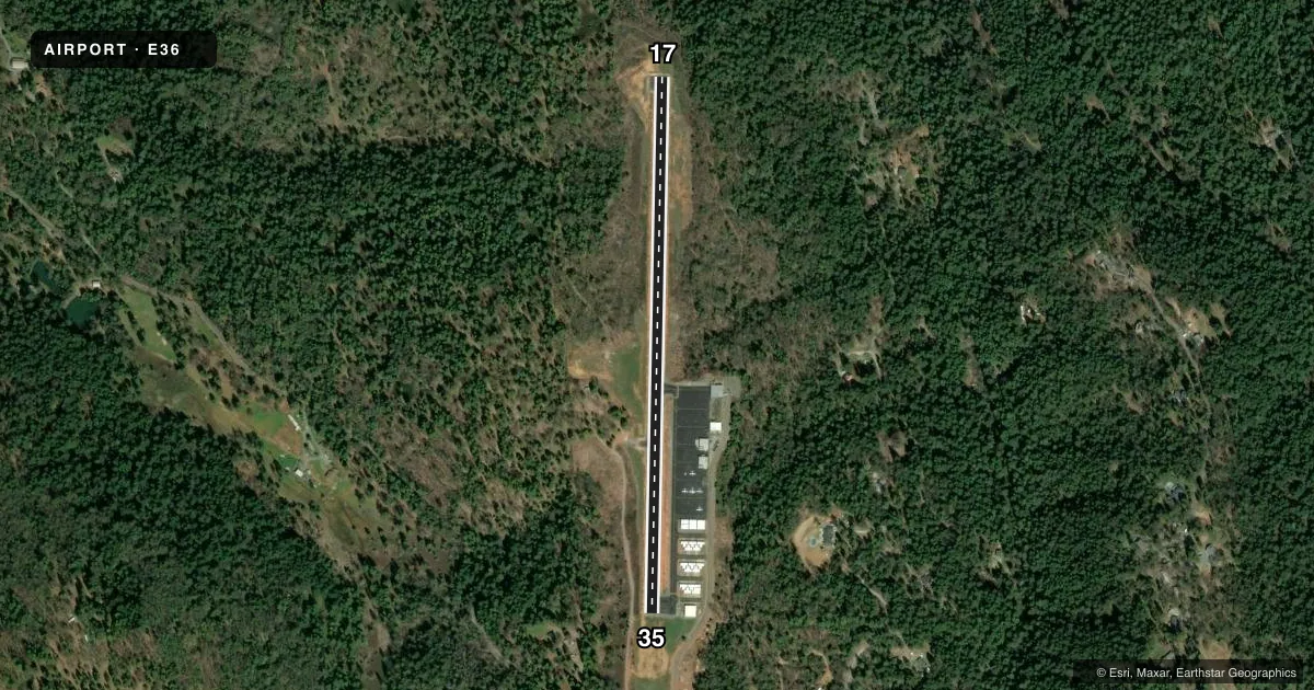
Airport sketch
Runways drawn to scale from FAA survey coordinates, rendered over satellite imagery. Not for navigation.
Approaches & charts
Services on the field
Fuel grades, oxygen, maintenance, ramp storage and lighting — as declared to the FAA by the airport operator.
Fuel & services
- Fuel
- 100LL
- Oxygen (bottled)
- Not available
- Oxygen (bulk)
- Not available
- Airframe repair
- Not available
- Power plant repair
- Not available
- Other services
- INSTR
Ramp & ground
- Transient storage
- Tie-down
- Landing fee
- No fee published
- Customs
- Not available
- Lighting schedule
- SEE RMK
- Beacon schedule
- SS-SR
- Beacon
- White / Green (civil land)(WG)
- Wind indicator
- Lighted
- Segmented circle
- No
Fuel & FBOs
Cheapest 100LL and Jet A on the field and nearby. Always confirm with the FBO before taxi.
Airport notes
Surface conditions, obstructions, local procedures, lighting outages and other notes published with each FAA cycle.
General notes
- RWY 17 POLES AT EDGE OF TREE LINE 145'-165' R ARE OBSTRUCTION LGTD.
- RWY 35 POLES AT THE EDGE OF TREE LINE 145 FT L ARE OBTSTRUCTION LGTD.
- TREES 800 FT SW OF RWY 17/35 2723 FT MSL (100 FT AGL) NOT LGTD .
- FOR CD CTC NORCAL APCH AT 916-361-6874.
Lighting notes
- ACTVT PAPI RWY 17; MIRL RWY 17/35 - CTAF.
VFR map & nearby airports
VFR sectional. Tap any ICAO chip to open that airport.
Key facts · E36
Answer card- ICAO
- E36
- Name
- GEORGETOWN
- Location
- GEORGETOWN, CALIFORNIA
- Elevation
- 2,624.9 ft MSL
- Traffic pattern altitude
- 3,424.9 ft MSL (800 AGL)
- Control tower
- Non-towered (use CTAF)
- Total runways
- 1
- Longest runway
- 17/35 · 2,979 ft
- Published ILS approaches
- 0
- Published frequencies
- 2
- Magnetic variation
- 16°
- Current flight rules
- VFR
- Current wind
- 080° at 6 kt
- Favored runway now
- RWY 35
Georgetown Airport sits in Georgetown, California. Field elevation is 2,624.9 ft MSL. The airport has one runway. Runway 17/35 is 2,979 ft long and asphalt. There is no control tower. CTAF and UNICOM are both 123.05. No ILS approaches are published.
Pattern altitude is 800 ft AGL. That puts the pattern at 3,424.9 ft MSL. The field is in the hills, so plan for elevation and terrain. Trees sit 800 feet southwest of runway 17/35. Poles near the tree line are lighted. Runway 17 has a PAPI. Medium intensity runway lights on 17 and 35 are activated by CTAF.
Georgetown Airport is on the field. Fuel grades are not reported, so call the airport directly at (530) 622-0459 before you go. For clearance delivery, contact NorCal Approach at 916-361-6874. If you are arriving IFR or want current local procedures, check the current FAA Chart Supplement before departure. The published remarks also call out obstructions near both runway ends, so a close look at the charted notes is smart before you descend into the valley.