METAR & TAF KLHM
Current METAR
Observed 09:15Z
KLHM 270915Z AUTO 16006KT 10SM CLR 20/09 A2993 RMK AO1
- Wind
- 160° @ 6 kt
- Visibility
- 10 SM
- Temp / Dew
- 20°C / 9°C
- Altimeter
- 29.93 inHg
- Clouds
- CLR
- Density alt
- 738 ft
- Ceiling
- Unlimited
- Rules
- VFR
Airport info & contacts
Manager on record, flight service, ARTCC, attendance schedule and pattern altitude — published by the FAA and refreshed every 28 days.
Location
- From city
- 3 NM W
- VFR sectional
- SAN FRANCISCO
- ARTCC
- ZOA · OAKLAND
- NOTAM facility
- RIU (NOTAM-D)
Airport manager
- Name
- RICHARD SPINALE
- Phone
- 916-645-3443
- Address
- 600 SIXTH STREET, LINCOLN CA 95648
Flight service · Hours
- FSS RIU
- RANCHO MURIETA1-800-WX-BRIEF
- Attendance
- MON-FRI · 0630 - 1500
Frequencies
Tap any row to copy the frequency to your clipboard.
Runways & pattern
Full pagePattern entry · RWY 15
LEFT TRAFFICRunway end performance
| End | TORA | TODA | ASDA | LDA | VGSI | Approach lights | Obstruction |
|---|---|---|---|---|---|---|---|
| 15 | — | — | — | — | PAPI 4-box left(3°) | MALSR | 25', tree, 1000' from thr, slope 32 |
| 33 | — | — | — | — | PAPI 4-box left(3°) | — | 40', trees, 1600' from thr, 0' R of cntrln, slope 35 |
Declared distances in feet. TORA = takeoff run available, TODA = takeoff distance, ASDA = accelerate-stop, LDA = landing distance.
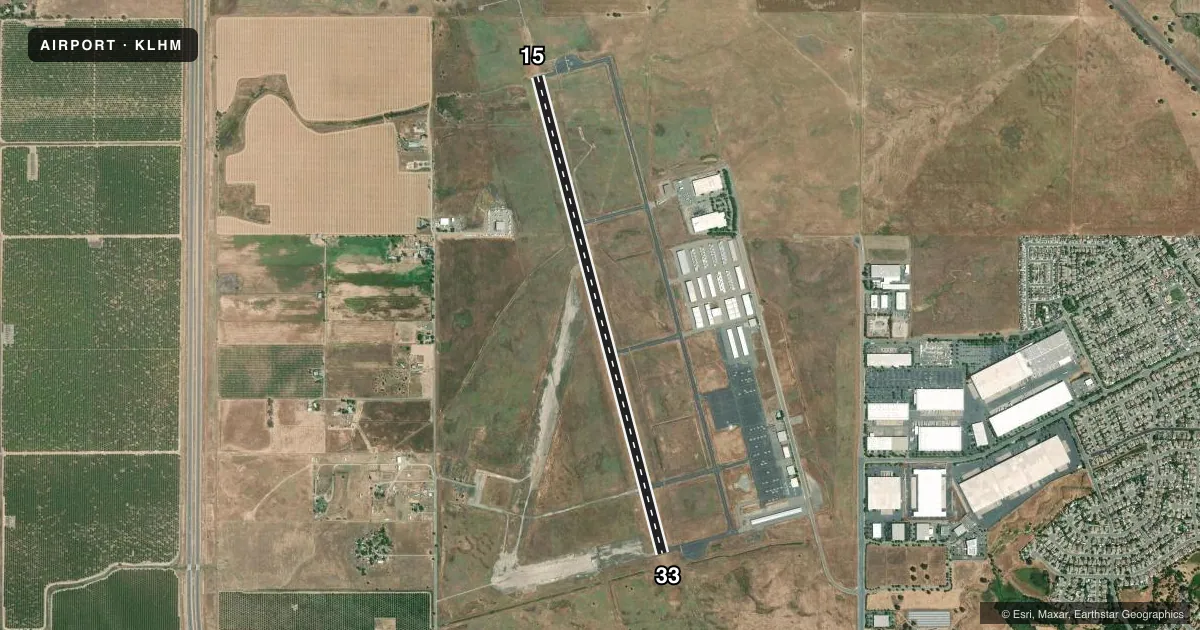
Airport sketch
Runways drawn to scale from FAA survey coordinates, rendered over satellite imagery. Not for navigation.
Approaches & charts
ILS · 1
Services on the field
Fuel grades, oxygen, maintenance, ramp storage and lighting — as declared to the FAA by the airport operator.
Fuel & services
- Fuel
- 100LLA
- Oxygen (bottled)
- Not available
- Oxygen (bulk)
- Not available
- Airframe repair
- Major
- Power plant repair
- Major
- Other services
- AVNCS,CHTR,INSTR,RNTL,SALES
Ramp & ground
- Transient storage
- Tie-down
- Landing fee
- No fee published
- Customs
- Not available
- Lighting schedule
- SEE RMK
- Beacon schedule
- SS-SR
- Beacon
- White / Green (civil land)(WG)
- Wind indicator
- Lighted
- Segmented circle
- Yes
Fuel & FBOs
Cheapest 100LL and Jet A on the field and nearby. Always confirm with the FBO before taxi.
Airport notes
Surface conditions, obstructions, local procedures, lighting outages and other notes published with each FAA cycle.
General notes
- FOR CD CTC NORCAL APCH AT 916-361-6874.
- PWRD PRCHT ACT SW QUAD OF ARPT.
Lighting notes
- ACTVT MALSR RWY 15; MIRL RWY 15/33, HELI PERIMETER LGTS - CTAF. PAPI RWYS 15 & 33 TURNED ON DURING DALGT HRS, AFTER DARK ACTVT - CTAF.
Fuel notes
- 100LLFOR JET A AND 100LL FUEL TRUCK CTC (916) 257-4854, 0600-1700. SELF SVC FUEL AVBL 24 HRS.
Approach & departure obstructions
- 15RY 15 CALM WND RY.
Other notes
- MANAGEREMAIL: RSPINALE@LINCOLNCA.GOV.
VFR map & nearby airports
VFR sectional. Tap any ICAO chip to open that airport.
Key facts · KLHM
Answer card- ICAO
- KLHM
- Name
- LINCOLN RGNL/KARL HARDER FLD
- Location
- LINCOLN, CALIFORNIA
- Elevation
- 121.4 ft MSL
- Traffic pattern altitude
- 1,121.4 ft MSL (1,000 AGL)
- Control tower
- Non-towered (use CTAF)
- Total runways
- 1
- Longest runway
- 15/33 · 6,001 ft
- Published ILS approaches
- 1
- Published frequencies
- 4
- Magnetic variation
- 14°
- Current flight rules
- VFR
- Current wind
- 160° at 6 kt
- Favored runway now
- RWY 15
Lincoln Regional Airport, also called Karl Harder Field, sits in Lincoln, California. Field elevation is 121.4 ft MSL. The airport has one runway. Runway 15/33 is 6,001 ft long and asphalt. There is no control tower, so expect non-towered ops on CTAF 123.0. The published pattern altitude is not listed, so use the standard 1,000 ft AGL for light piston traffic unless the current Chart Supplement says otherwise.
This field has one ILS approach to runway 15. The runway lighting setup is worth a look before you go. Medium intensity approach lighting with runway alignment indicator lights serves runway 15. Medium intensity runway lights are available on 15 and 33. The precision approach path indicators for 15 and 33 are on during daylight hours. After dark, they are activated by CTAF. Runway 15 is published as the calm wind runway.
Lincoln Regional Airport is the on-field FBO. It carries 100LL, Jet A and Jet A Prist. Self-serve fuel is available 24 hours. For Jet A and 100LL fuel truck service, call the fuel truck at (916) 257-4854 between 0600 and 1700. For clearance delivery, contact NorCal Approach at 916-361-6874. A powered parachute operates in the southwest quadrant of the airport. Keep an eye out in the pattern and on taxi. Check the current FAA Chart Supplement for any noise or curfew restrictions before flying in.