METAR & TAF O52
O52 does not publish a METAR.
Showing the nearest reporting station: KMYV (YUBA COUNTY) · 2.3 NM away. Conditions at O52 may differ.
METAR · KMYV
Observed 23:53Z
KMYV 232353Z AUTO 20006KT 10SM CLR 34/07 A2989 RMK AO2 SLP126 T03440067 10344 20239 56019 $
- Wind
- 200° @ 6 kt
- Visibility
- 10 SM
- Temp / Dew
- 34°C / 7°C
- Altimeter
- 29.89 inHg
- Clouds
- CLR
- Density alt
- 2,391 ft
- Ceiling
- Unlimited
- Rules
- VFR
Airport info & contacts
Manager on record, flight service, ARTCC, attendance schedule and pattern altitude — published by the FAA and refreshed every 28 days.
Location
- From city
- 1 NM S
- VFR sectional
- SAN FRANCISCO
- ARTCC
- ZOA · OAKLAND
- NOTAM facility
- RIU (NOTAM-D)
Airport manager
- Name
- NEAL HAY
- Phone
- (530) 822-7400
- Address
- 1130 CIVIC CENTER BLVD, YUBA CITY CA 95993
Flight service · Hours
- FSS RIU
- RANCHO MURIETA1-800-WX-BRIEF
- Attendance
- MON-FRI · 0800-1700
Frequencies
Tap any row to copy the frequency to your clipboard.
Runways & pattern
Full pagePattern entry · RWY 17
RIGHT TRAFFICRunway end performance
| End | TORA | TODA | ASDA | LDA | VGSI | Approach lights | Obstruction |
|---|---|---|---|---|---|---|---|
| 17 | — | — | — | — | PAPI 2-box left(3°) | — | — |
| 35 | — | — | — | — | — | — | 65', trees, 1488' from thr, 0' R of cntrln, slope 20 |
Declared distances in feet. TORA = takeoff run available, TODA = takeoff distance, ASDA = accelerate-stop, LDA = landing distance.
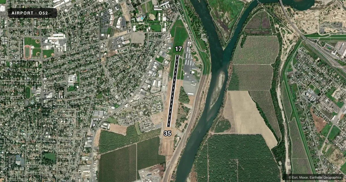
Airport sketch
Runways drawn to scale from FAA survey coordinates, rendered over satellite imagery. Not for navigation.
Approaches & charts
Services on the field
Fuel grades, oxygen, maintenance, ramp storage and lighting — as declared to the FAA by the airport operator.
Fuel & services
- Fuel
- 100LL
- Oxygen (bottled)
- Not available
- Oxygen (bulk)
- Not available
- Airframe repair
- Major
- Power plant repair
- Major
- Other services
- AGRI,INSTR,RNTL,SALES
Ramp & ground
- Transient storage
- Tie-down
- Landing fee
- No fee published
- Customs
- Not available
- Lighting schedule
- SEE RMK
- Beacon schedule
- SS-SR
- Beacon
- White / Green (civil land)(WG)
- Wind indicator
- Lighted
- Segmented circle
- Yes
Fuel & FBOs
Cheapest 100LL and Jet A on the field and nearby. Always confirm with the FBO before taxi.
Airport notes
Surface conditions, obstructions, local procedures, lighting outages and other notes published with each FAA cycle.
General notes
- AGRICULTURAL ACFT FLY NON STANDARD TFC PATTERN.
- (E81) TWY REFLECTORS; LGTD EXIT ARROWS.
- FOR CD CTC NORCAL APCH AT 916-361-6874.
Lighting notes
- ACTVT MIRL RY 17/35 - CTAF.
Fuel notes
- 100LLFUEL AVBL BY CREDIT CARD.
Other notes
- THIS AIRPORT HAS BEEN SURVEYED BY THE NATIONAL GEODETIC SURVEY.
- MANAGERARPT PHONE 530-674-9645.
VFR map & nearby airports
VFR sectional. Tap any ICAO chip to open that airport.
Key facts · O52
Answer card- ICAO
- O52
- Name
- SUTTER COUNTY
- Location
- YUBA CITY, CALIFORNIA
- Elevation
- 59.6 ft MSL
- Traffic pattern altitude
- 1,059.6 ft MSL (1,000 AGL)
- Control tower
- Non-towered (use CTAF)
- Total runways
- 1
- Longest runway
- 17/35 · 3,045 ft
- Published ILS approaches
- 0
- Published frequencies
- 2
- Magnetic variation
- 16°
- Current flight rules
- VFR
- Current wind
- 200° at 6 kt
- Favored runway now
- RWY 17
Sutter County Airport (O52) sits in Yuba City, California. The field elevation is 59.6 ft MSL. It has one runway, 17/35, which is 3,045 ft long and paved with asphalt. There is no control tower. CTAF and UNICOM are both 122.7.
No ILS approaches are published here. The pattern altitude is not published in the facts, so use the standard 1,000 ft AGL for light piston traffic unless the current Chart Supplement says otherwise. The airport is in a low-elevation valley setting, so density altitude is usually less of a concern than at higher fields, but you should still check conditions before departure.
The on-field FBO is Sutter County Airport. It carries 100LL. Fuel is available by credit card. Published remarks also note that medium intensity runway lights on 17/35 are activated by CTAF. Taxiway reflectors and lighted exit arrows are installed. Agricultural aircraft use a nonstandard traffic pattern here, so give that traffic extra room. Expect it to be different from the standard pattern. For clearance delivery, contact NorCal Approach. First-time arrivals should review the current Chart Supplement for any local procedures before flying in.