METAR & TAF O08
O08 does not publish a METAR.
Showing the nearest reporting station: KMYV (YUBA COUNTY) · 20.3 NM away. Conditions at O08 may differ.
METAR · KMYV
Observed 23:53Z
KMYV 232353Z AUTO 20006KT 10SM CLR 34/07 A2989 RMK AO2 SLP126 T03440067 10344 20239 56019 $
- Wind
- 200° @ 6 kt
- Visibility
- 10 SM
- Temp / Dew
- 34°C / 7°C
- Altimeter
- 29.89 inHg
- Clouds
- CLR
- Density alt
- 2,378 ft
- Ceiling
- Unlimited
- Rules
- VFR
Airport info & contacts
Manager on record, flight service, ARTCC, attendance schedule and pattern altitude — published by the FAA and refreshed every 28 days.
Location
- From city
- 3 NM S
- VFR sectional
- SAN FRANCISCO
- Pattern altitude
- 800 ft AGL · 849 ft MSL
- ARTCC
- ZOA · OAKLAND
- NOTAM facility
- RIU (NOTAM-D)
Airport manager
- Name
- SCOTT LANPHIER
- Phone
- 530-458-0466
- Address
- 1215 MARKET ST, SUITE F, COLUSA CA 95932-3246
Flight service · Hours
- FSS RIU
- RANCHO MURIETA1-800-WX-BRIEF
- Attendance
- DAWN-DUSK
Frequencies
Tap any row to copy the frequency to your clipboard.
Runways & pattern
Full pagePattern entry · RWY 14
LEFT TRAFFICRunway end performance
| End | TORA | TODA | ASDA | LDA | VGSI | Approach lights | Obstruction |
|---|---|---|---|---|---|---|---|
| 14 | — | — | — | — | PAPI 2-box left(3°) | — | — |
| 32 | — | — | — | — | PAPI 2-box left(3°) | — | 15', road, 450' from thr, 100' R of cntrln, slope 16 |
Declared distances in feet. TORA = takeoff run available, TODA = takeoff distance, ASDA = accelerate-stop, LDA = landing distance.
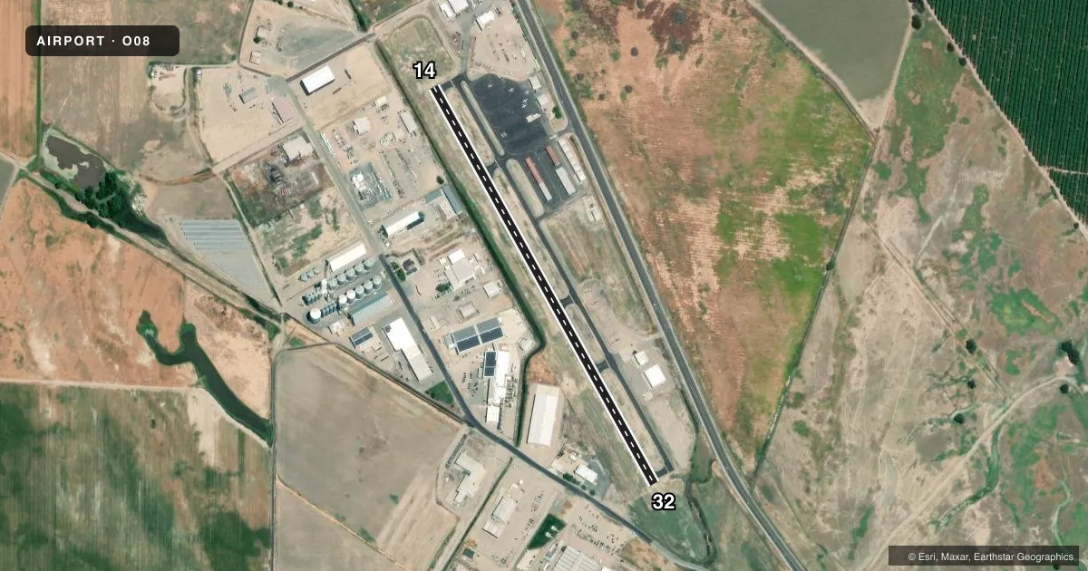
Airport sketch
Runways drawn to scale from FAA survey coordinates, rendered over satellite imagery. Not for navigation.
Approaches & charts
Services on the field
Fuel grades, oxygen, maintenance, ramp storage and lighting — as declared to the FAA by the airport operator.
Fuel & services
- Fuel
- 100LL
- Oxygen (bottled)
- Not available
- Oxygen (bulk)
- Not available
- Airframe repair
- Major
- Power plant repair
- Major
- Other services
- AGRI,CHTR,INSTR,RNTL
Ramp & ground
- Transient storage
- Tie-down
- Landing fee
- No fee published
- Customs
- Not available
- Lighting schedule
- SEE RMK
- Beacon schedule
- SS-SR
- Beacon
- White / Green (civil land)(WG)
- Wind indicator
- Lighted
- Segmented circle
- Yes
Fuel & FBOs
Cheapest 100LL and Jet A on the field and nearby. Always confirm with the FBO before taxi.
Airport notes
Surface conditions, obstructions, local procedures, lighting outages and other notes published with each FAA cycle.
General notes
- BE ALERT TO BLDG 120 FT AGL 1000 FT WEST.
- (E81) RWY EXIT LGTS ONLY.
- BIRDS ON AND IN VICINITY OF AIRPORT
- FOR CD CTC OAKLAND ARTCC AT 510-745-3380.
Lighting notes
- ACTVT MIRL RWY 14/32 - CTAF.
Fuel notes
- 100LLFUEL AVBL BY CREDIT CARD 24/7
Other notes
- MANAGERCOUNTY PUB WORKS DIR. ARPT MGR 530-682-2612.
VFR map & nearby airports
VFR sectional. Tap any ICAO chip to open that airport.
Key facts · O08
Answer card- ICAO
- O08
- Name
- SIDNEY PICKELS FLD
- Location
- COLUSA, CALIFORNIA
- Elevation
- 49 ft MSL
- Traffic pattern altitude
- 849 ft MSL (800 AGL)
- Control tower
- Non-towered (use CTAF)
- Total runways
- 1
- Longest runway
- 14/32 · 3,034 ft
- Published ILS approaches
- 0
- Published frequencies
- 2
- Magnetic variation
- 13°
- Current flight rules
- VFR
- Current wind
- 200° at 6 kt
- Favored runway now
- RWY 14
Colusa County Airport sits in Colusa, California. Field elevation is 49 ft MSL. The airport has one runway. Runway 14/32 is 3,034 ft long and asphalt. There is no control tower. CTAF and UNICOM are both 122.8. No ILS approaches are published, so plan with the current chart and weather brief before you go.
Pattern altitude is 800 ft AGL, which is 849 ft MSL. The field uses medium intensity runway lights on 14/32. They are activated by CTAF. Fuel is available from Colusa County Airport. It carries AVGAS 100LL. Fuel is available by credit card 24 hours a day, 7 days a week. That makes it a practical stop for light GA traffic.
A first-time pilot should pay attention to the published remarks. Birds are on and near the airport. There is also a building about 1,000 ft west that rises 120 ft AGL. Runway exit lights are the only exit lighting noted. For clearance delivery, contact Oakland ARTCC at 510-745-3380. If you need current operational details, call the airport operator or the FBO directly before departure.