METAR & TAF KOVE
Current METAR
Observed 09:53Z
KOVE 270953Z AUTO 14006KT 10SM CLR 21/13 A2994 RMK AO2 SLP139 T02060128
- Wind
- 140° @ 6 kt
- Visibility
- 10 SM
- Temp / Dew
- 21°C / 13°C
- Altimeter
- 29.94 inHg
- Clouds
- CLR
- Density alt
- 936 ft
- Ceiling
- Unlimited
- Rules
- VFR
Airport info & contacts
Manager on record, flight service, ARTCC, attendance schedule and pattern altitude — published by the FAA and refreshed every 28 days.
Location
- From city
- 3 NM SW
- VFR sectional
- SAN FRANCISCO
- Pattern altitude
- 800 ft AGL · 994 ft MSL
- ARTCC
- ZOA · OAKLAND
- NOTAM facility
- OVE (NOTAM-D)
Airport manager
- Name
- CODY NISSEN
- Phone
- 530-538-2490
- Address
- 1735 MONTGOMERY ST., OROVILLE CA 95965
Flight service · Hours
- FSS RIU
- RANCHO MURIETA1-800-WX-BRIEF
- Attendance
- MON-SAT · 0800-1700
Frequencies
Tap any row to copy the frequency to your clipboard.
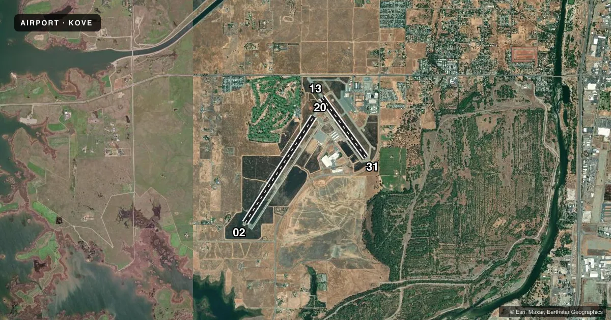
Runways & pattern
Full pagePattern entry · RWY 13
LEFT TRAFFIC| Runway | Heading (°M) | Length | Surface | Traffic |
|---|---|---|---|---|
| 02/20 | 17° / 197° | 6,020 ft | ASPH | Standard L |
| 13/31Favored | 128° / 308° | 3,540 ft | ASPH | Standard L |
Runway end performance
| End | TORA | TODA | ASDA | LDA | VGSI | Approach lights | Obstruction |
|---|---|---|---|---|---|---|---|
| 02 | — | — | — | — | PAPI 2-box left(3°) | — | — |
| 20 | — | — | — | — | PAPI 2-box left(3°) | — | — |
| 13 | — | — | — | — | PAPI 2-box left(3°) | — | — |
| 31 | — | — | — | — | PAPI 2-box left(3°) | — | 20', trees, 600' from thr, 200' R of cntrln, slope 20 |
Declared distances in feet. TORA = takeoff run available, TODA = takeoff distance, ASDA = accelerate-stop, LDA = landing distance.
Airport sketch
Runways drawn to scale from FAA survey coordinates, rendered over satellite imagery. Not for navigation.
Approaches & charts
Services on the field
Fuel grades, oxygen, maintenance, ramp storage and lighting — as declared to the FAA by the airport operator.
Fuel & services
- Fuel
- 100LLA
- Oxygen (bottled)
- Not available
- Oxygen (bulk)
- Not available
- Airframe repair
- Major
- Power plant repair
- Minor
- Other services
- INSTR
Ramp & ground
- Transient storage
- Tie-down
- Landing fee
- No fee published
- Customs
- Not available
- Lighting schedule
- SEE RMK
- Beacon schedule
- SS-SR
- Beacon
- White / Green (civil land)(WG)
- Wind indicator
- Lighted
- Segmented circle
- Yes
Fuel & FBOs
Cheapest 100LL and Jet A on the field and nearby. Always confirm with the FBO before taxi.
Airport notes
Surface conditions, obstructions, local procedures, lighting outages and other notes published with each FAA cycle.
General notes
- TWY FROM RY 02/20 TO GOLF COURSE/RESTAURANT TIEDOWNS 20 FT WIDE WITH NO SHOULDERS.
- FIREFIGHTING ACFT INVOF ARPT MAY-OCT.
- FOR ARPT INFO MON-FRI CTC (530) 538-2420.
- FOR CD CTC NORCAL APCH AT 916-361-6874.
Lighting notes
- ACTVT REIL RWY 02 & 20; PAPI RWY 02, 13, 20 & 31; HIRL RWY 02/20 & RWY 13/31 - CTAF.
Approach & departure obstructions
- 20DOES NOT PRVD OBSTN CLNC BYD 3 NM.
VFR map & nearby airports
VFR sectional. Tap any ICAO chip to open that airport.
Key facts · KOVE
Answer card- ICAO
- KOVE
- Name
- OROVILLE MUNI
- Location
- OROVILLE, CALIFORNIA
- Elevation
- 194.2 ft MSL
- Traffic pattern altitude
- 994.2 ft MSL (800 AGL)
- Control tower
- Non-towered (use CTAF)
- Total runways
- 2
- Longest runway
- 02/20 · 6,020 ft
- Published ILS approaches
- 0
- Published frequencies
- 4
- Magnetic variation
- 16°
- Current flight rules
- VFR
- Current wind
- 140° at 6 kt
- Favored runway now
- RWY 13
Oroville Muni is in Oroville, California. Field elevation is 194.2 ft MSL. The airport has two asphalt runways. The longest is 6,020 ft on 02/20. There is no control tower, so expect non-towered traffic flow on CTAF 122.8. Pattern altitude is 800 ft AGL, which is 994.2 ft MSL.
No ILS approaches are published here. For IFR work, use the current Chart Supplement for the latest approach and airport details. The on-field FBO is Oroville Municipal Airport. It carries 100LL, Jet A and Jet A Prist. Call (530) 533-1313 for current service status.
A few published remarks matter here. The taxiway from runway 02/20 to the golf course and restaurant tiedowns is only 20 feet wide with no shoulders. Runway 20 does not provide obstacle clearance beyond 3 NM. Firefighting aircraft are in the vicinity from May through October. Runway end identifier lights are on 02 and 20. PAPI is on 02, 13, 20 and 31. High intensity runway lights are on both runways and are controlled by CTAF. First-time pilots should plan for a non-towered field with active local traffic. Verify current airport details before arrival.